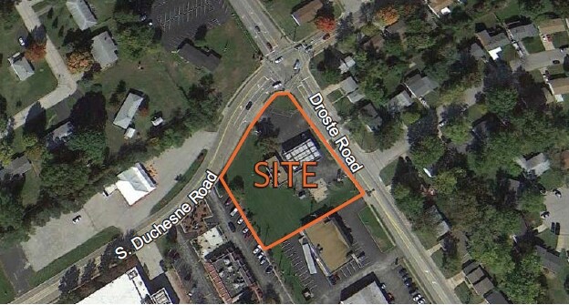
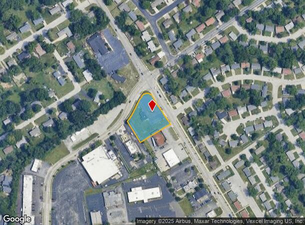
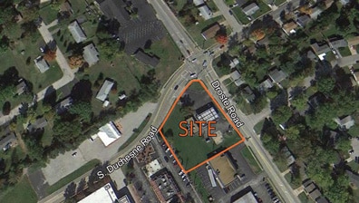
Property Record
2305 Droste Rd, Saint Charles, MO 63301
This Property Is For Sale
NEARBY LISTINGS FOR SALE OR LEASE
Property Detail
2305 Droste Rd
St. Louis, MO-IL
Flair Forest 04
6-010A-3280-00-0012.9000000
ST CHAS COMMON BLK 6 PT LOT 14
Commercialnec
St. Charles
X
Missouri
29183C0267G
14
2024
0.95 AC
2025
St Charles County
310700
St. Louis
1,180 SF
DEMOGRAPHICS near 2305 Droste Rd
1 Mile
3 Mile
5 Mile
2024 Total Population
13,922
77,156
128,349
2029 Population
14,746
81,835
135,832
Pop Growth 2024-2029
+ 5.92%
+ 6.06%
+ 5.83%
Average Age
39
42
42
2024 Total Households
5,498
33,004
54,016
HH Growth 2024-2029
+ 6.28%
+ 6.21%
+ 5.96%
Median Household Inc
$56,587
$74,156
$82,074
Avg Household Size
2.00
2.20
2.30
2024 Avg HH Vehicles
2.00
2.00
2.00
Median Home Value
$191,468
$245,107
$253,284
Median Year Built
1971
1980
1984
Nearby Places
Map Layers
Map Styles
 Street
 Aerial
- Restaurants
- Banks
- Shops
- Fitness
- Groceries
PUBLIC TRANSPORTATION
AIRPORT
St Louis Lambert International
DRIVE
WALK
Distance
St Louis Lambert International
19 min
12.4 mi
Freight Ports
Port Milwaukee
DRIVE
WALK
Distance
Port Milwaukee
439 min
385.6 mi
Nearby Properties
Address
Land Use
TOTAL SIZE
Lot Size
Zoning
Address
Land Use
TOTAL SIZE
Lot Size
Zoning
2,918,475 SF
30.32 AC
AC1
Address
Land Use
TOTAL SIZE
Lot Size
Zoning
553,382 SF
109.67 AC
FPNU
Address
Land Use
TOTAL SIZE
Lot Size
Zoning
440,000 SF
2.11 AC
Address
Land Use
TOTAL SIZE
Lot Size
Zoning
140,801 SF
6.35 AC
Address
Land Use
TOTAL SIZE
Lot Size
Zoning
581,756 SF
47.18 AC
AC2
Address
Land Use
TOTAL SIZE
Lot Size
Zoning
43,890 SF
28.96 AC
Address
Land Use
TOTAL SIZE
Lot Size
Zoning
564,552 SF
42.07 AC
10M-1
Address
Land Use
TOTAL SIZE
Lot Size
Zoning
201,270 SF
13.01 AC
Address
Land Use
TOTAL SIZE
Lot Size
Zoning
488,536 SF
23.53 AC
AF0
Address
Land Use
TOTAL SIZE
Lot Size
Zoning
281,074 SF
8.79 AC
Address
Land Use
TOTAL SIZE
Lot Size
Zoning
312,516 SF
2.18 AC
Address
Land Use
TOTAL SIZE
Lot Size
Zoning
120,050 SF
1.51 AC
Address
Land Use
TOTAL SIZE
Lot Size
Zoning
197,290 SF
29.28 AC
Address
Land Use
TOTAL SIZE
Lot Size
Zoning
395,327 SF
34.69 AC
Address
Land Use
TOTAL SIZE
Lot Size
Zoning
87,027 SF
16.04 AC
AC4
Address
Land Use
TOTAL SIZE
Lot Size
Zoning
83.11 AC
AC9
Address
Land Use
TOTAL SIZE
Lot Size
Zoning
317,145 SF
21.71 AC
10M-1
Address
Land Use
TOTAL SIZE
Lot Size
Zoning
273,398 SF
20.08 AC
AB2
Address
Land Use
TOTAL SIZE
Lot Size
Zoning
15,584 SF
50 AC
AC9
Address
Land Use
TOTAL SIZE
Lot Size
Zoning
316,064 SF
1.84 AC
Address
Land Use
TOTAL SIZE
Lot Size
Zoning
55.46 AC
AF0
Address
Land Use
TOTAL SIZE
Lot Size
Zoning
220,089 SF
25.47 AC
AA7
Address
Land Use
TOTAL SIZE
Lot Size
Zoning
100,633 SF
1.02 AC
Address
Land Use
TOTAL SIZE
Lot Size
Zoning
263,495 SF
20.10 AC
Address
Land Use
TOTAL SIZE
Lot Size
Zoning
320,000 SF
17.30 AC
FPM3
Address
Land Use
TOTAL SIZE
Lot Size
Zoning
199,216 SF
10.26 AC
Address
Land Use
TOTAL SIZE
Lot Size
Zoning
19,493 SF
3.01 AC
Address
Land Use
TOTAL SIZE
Lot Size
Zoning
63.61 AC
AC9
Address
Land Use
TOTAL SIZE
Lot Size
Zoning
61,292 SF
9.50 AC
Address
Land Use
TOTAL SIZE
Lot Size
Zoning
285,738 SF
117.71 AC
AB6
The World's #1 Commercial Real Estate Marketplace
Connect with us
© 2025 CoStar Group
The information above has been obtained from sources believed reliable. While we do not doubt its accuracy we have not verified it and make no guarantee, warranty or representation about it. It is your responsibility to independently confirm its accuracy and completeness. Any projections, opinions, assumptions, or estimates used are for example only and do not represent the current or future performance of the property. The value of this transaction to you depends on tax and other factors which should be evaluated by your tax, financial, and legal advisors. You and your advisors should conduct a careful, independent investigation of the property to determine to your satisfaction the suitability of the property for your needs.