Property Record
23065 State Highway 242, New Caney, TX 77357
This Property Is For Sale
NEARBY LISTINGS FOR SALE OR LEASE
Property Detail
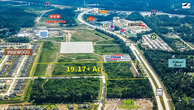
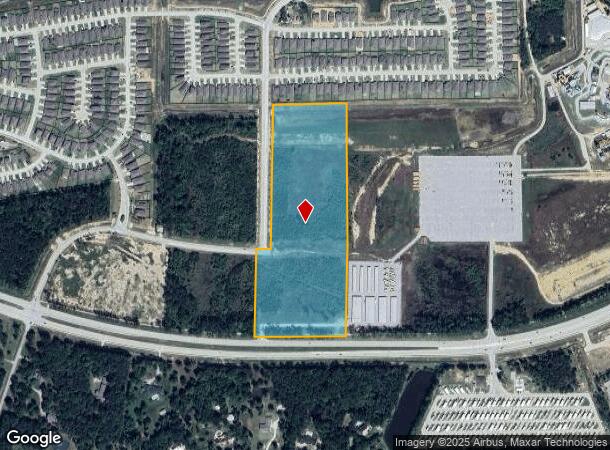
23065 State Highway 242
Houston-The Woodlands-Sugar Land, TX
Peters H A
0382-00-00113
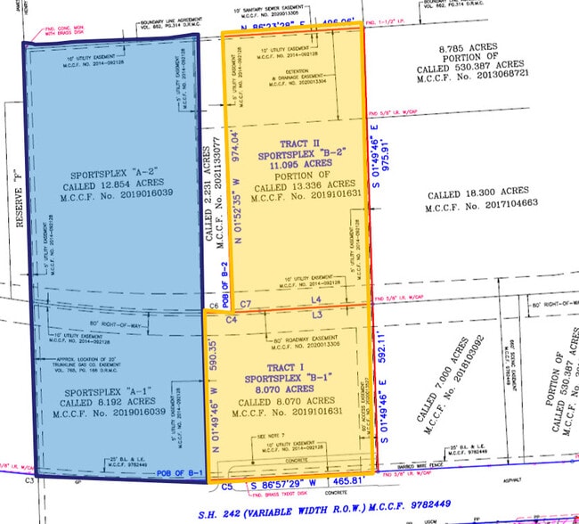
A0434 - PETERS H A, TRACT 8-C, ACRES 19.175
Commercialacreage
Montgomery
X
Texas
2024
19.18 AC
2025
Outlying Montgomery Cnty
692702
Houston
DEMOGRAPHICS near 23065 State Highway 242
1 Mile
3 Mile
5 Mile
2024 Total Population
1,413
20,167
50,448
2029 Population
1,685
25,453
63,145
Pop Growth 2024-2029
+ 19.25%
+ 26.21%
+ 25.17%
Average Age
41
38
36
2024 Total Households
476
6,766
16,382
HH Growth 2024-2029
+ 19.54%
+ 26.25%
+ 25.30%
Median Household Inc
$112,500
$88,484
$72,968
Avg Household Size
2.90
2.90
3.00
2024 Avg HH Vehicles
3.00
2.00
2.00
Median Home Value
$390,322
$253,227
$222,617
Median Year Built
2003
2006
2003
Nearby Places
Map Layers
Map Styles
 Street
 Aerial
- Restaurants
- Banks
- Shops
- Fitness
- Groceries
PUBLIC TRANSPORTATION
AIRPORT
George Bush Intcntl/Houston
DRIVE
WALK
Distance
George Bush Intcntl/Houston
30 min
23.4 mi
Freight Ports
Port of Houston
DRIVE
WALK
Distance
Port of Houston
51 min
38.7 mi
Nearby Properties
Address
Land Use
TOTAL SIZE
Lot Size
Zoning
Address
Land Use
TOTAL SIZE
Lot Size
Zoning
131,364 SF
4.63 AC
5
Address
Land Use
TOTAL SIZE
Lot Size
Zoning
110,013 SF
13.91 AC
5
Address
Land Use
TOTAL SIZE
Lot Size
Zoning
137,928 SF
15.01 AC
Address
Land Use
TOTAL SIZE
Lot Size
Zoning
102,184 SF
20.35 AC
Address
Land Use
TOTAL SIZE
Lot Size
Zoning
54,372 SF
6.26 AC
Address
Land Use
TOTAL SIZE
Lot Size
Zoning
68,756 SF
2.10 AC
Address
Land Use
TOTAL SIZE
Lot Size
Zoning
61,628 SF
30.91 AC
5
Address
Land Use
TOTAL SIZE
Lot Size
Zoning
15,368 SF
12.24 AC
Address
Land Use
TOTAL SIZE
Lot Size
Zoning
20,200 SF
26.46 AC
Address
Land Use
TOTAL SIZE
Lot Size
Zoning
15,000 SF
1.57 AC
Address
Land Use
TOTAL SIZE
Lot Size
Zoning
55,676 SF
5.40 AC
5
Address
Land Use
TOTAL SIZE
Lot Size
Zoning
3,597 SF
17.87 AC
Address
Land Use
TOTAL SIZE
Lot Size
Zoning
48,405 SF
30.58 AC
5
Address
Land Use
TOTAL SIZE
Lot Size
Zoning
15,638 SF
17.29 AC
5
Address
Land Use
TOTAL SIZE
Lot Size
Zoning
62,486 SF
3.53 AC
5
Address
Land Use
TOTAL SIZE
Lot Size
Zoning
18.30 AC
Address
Land Use
TOTAL SIZE
Lot Size
Zoning
77,118 SF
5.64 AC
5
Address
Land Use
TOTAL SIZE
Lot Size
Zoning
3,880 SF
13.32 AC
5
Address
Land Use
TOTAL SIZE
Lot Size
Zoning
13,420 SF
7.82 AC
5
Address
Land Use
TOTAL SIZE
Lot Size
Zoning
5,900 SF
2.97 AC
Address
Land Use
TOTAL SIZE
Lot Size
Zoning
8,432 SF
2.87 AC
Address
Land Use
TOTAL SIZE
Lot Size
Zoning
48,400 SF
4.14 AC
Address
Land Use
TOTAL SIZE
Lot Size
Zoning
19,587 SF
3.50 AC
Address
Land Use
TOTAL SIZE
Lot Size
Zoning
11,064 SF
1.20 AC
Address
Land Use
TOTAL SIZE
Lot Size
Zoning
50,960 SF
6.06 AC
The World's #1 Commercial Real Estate Marketplace
Connect with us
© 2025 CoStar Group
The information above has been obtained from sources believed reliable. While we do not doubt its accuracy we have not verified it and make no guarantee, warranty or representation about it. It is your responsibility to independently confirm its accuracy and completeness. Any projections, opinions, assumptions, or estimates used are for example only and do not represent the current or future performance of the property. The value of this transaction to you depends on tax and other factors which should be evaluated by your tax, financial, and legal advisors. You and your advisors should conduct a careful, independent investigation of the property to determine to your satisfaction the suitability of the property for your needs.