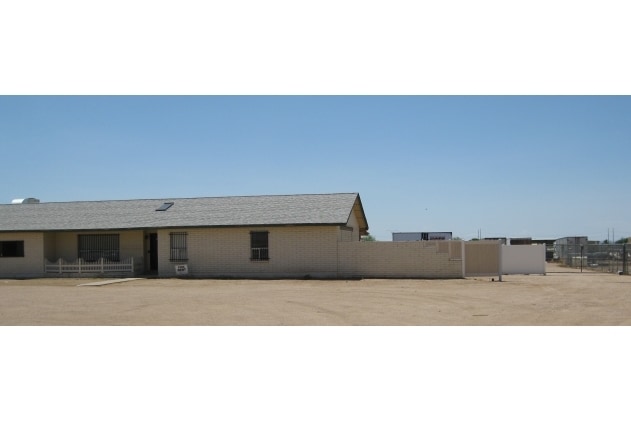
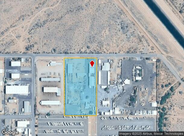
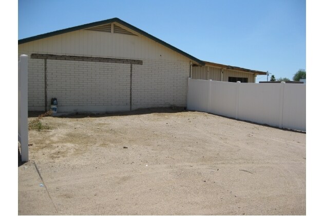
Property Record
2307 W Houston Ave, Apache Junction, AZ 85120

NEARBY LISTINGS FOR SALE OR LEASE
-
-
View all Apache Junction listings for sale on LoopNet.com
Property Detail
2307 W Houston Ave
104-63-002C
E1/2 NW NW SE OF SEC 6-1S-8E EXC THE N-40 OF SEC 6-1S-8E 4.70 AC
Commercialnec
Pinal
X
Arizona
04013C2780L
4.70 AC
2024
Pinal County
2025
Phoenix
000319
Phoenix-Mesa-Scottsdale, AZ
17,696 SF
DEMOGRAPHICS near 2307 W Houston Ave
1 Mile
3 Mile
5 Mile
2024 Total Population
2,759
61,840
170,965
2029 Population
3,391
71,684
195,524
Pop Growth 2024-2029
+ 22.91%
+ 15.92%
+ 14.36%
Average Age
60
43
42
2024 Total Households
1,379
23,771
65,723
HH Growth 2024-2029
+ 22.26%
+ 16.84%
+ 15.05%
Median Household Inc
$59,432
$72,153
$71,843
Avg Household Size
2.00
2.50
2.50
2024 Avg HH Vehicles
1.00
2.00
2.00
Median Home Value
$156,097
$325,731
$322,953
Median Year Built
2000
2000
1999
Nearby Places
Map Layers
Map Styles
 Street
 Aerial
- Restaurants
- Banks
- Shops
- Fitness
- Groceries
PUBLIC TRANSPORTATION
AIRPORT
Phoenix-Mesa Gateway
DRIVE
WALK
Distance
Phoenix-Mesa Gateway
28 min
16.1 mi
Phoenix Sky Harbor International
DRIVE
WALK
Distance
Phoenix Sky Harbor International
45 min
31.9 mi
Freight Ports
Port of San Diego
DRIVE
WALK
Distance
Port of San Diego
432 min
388.6 mi
Nearby Properties
Address
Land Use
TOTAL SIZE
Lot Size
Zoning
Address
Land Use
TOTAL SIZE
Lot Size
Zoning
493,357 SF
46.94 AC
C-N
Address
Land Use
TOTAL SIZE
Lot Size
Zoning
108,297 SF
102.46 AC
PS
Address
Land Use
TOTAL SIZE
Lot Size
Zoning
Address
Land Use
TOTAL SIZE
Lot Size
Zoning
128,905 SF
7.14 AC
UNDESIGNAT
Address
Land Use
TOTAL SIZE
Lot Size
Zoning
Address
Land Use
TOTAL SIZE
Lot Size
Zoning
Address
Land Use
TOTAL SIZE
Lot Size
Zoning
209,737 SF
21.98 AC
UNDESIGNAT
Address
Land Use
TOTAL SIZE
Lot Size
Zoning
1,355,382 SF
83.17 AC
PAD
Address
Land Use
TOTAL SIZE
Lot Size
Zoning
467,727 SF
104.86 AC
AG
Address
Land Use
TOTAL SIZE
Lot Size
Zoning
454,704 SF
101.68 AC
AG
Address
Land Use
TOTAL SIZE
Lot Size
Zoning
126,549 SF
9.75 AC
Address
Land Use
TOTAL SIZE
Lot Size
Zoning
52,961 SF
7.94 AC
Address
Land Use
TOTAL SIZE
Lot Size
Zoning
108,644 SF
10.12 AC
UNDESIGNAT
Address
Land Use
TOTAL SIZE
Lot Size
Zoning
54,706 SF
16.20 AC
UNDESIGNAT
Address
Land Use
TOTAL SIZE
Lot Size
Zoning
779,546 SF
53.20 AC
LI
Address
Land Use
TOTAL SIZE
Lot Size
Zoning
422,427 SF
18.21 AC
C-C
Address
Land Use
TOTAL SIZE
Lot Size
Zoning
Address
Land Use
TOTAL SIZE
Lot Size
Zoning
173,840 SF
6 AC
UNDESIGNAT
Address
Land Use
TOTAL SIZE
Lot Size
Zoning
38,353 SF
5 AC
Address
Land Use
TOTAL SIZE
Lot Size
Zoning
4.77 AC
LC
Address
Land Use
TOTAL SIZE
Lot Size
Zoning
30,775 SF
7.60 AC
UNDESIGNAT
Address
Land Use
TOTAL SIZE
Lot Size
Zoning
345,968 SF
14.65 AC
RM4
Address
Land Use
TOTAL SIZE
Lot Size
Zoning
102,430 SF
5 AC
UNDESIGNAT
Address
Land Use
TOTAL SIZE
Lot Size
Zoning
27,121 SF
4.05 AC
Address
Land Use
TOTAL SIZE
Lot Size
Zoning
196,400 SF
15.67 AC
Address
Land Use
TOTAL SIZE
Lot Size
Zoning
961,432 SF
63.41 AC
Address
Land Use
TOTAL SIZE
Lot Size
Zoning
683 SF
36.74 AC
UNDESIGNAT
Address
Land Use
TOTAL SIZE
Lot Size
Zoning
24,158 SF
5.19 AC
Address
Land Use
TOTAL SIZE
Lot Size
Zoning
13.52 AC
The World's #1 Commercial Real Estate Marketplace
Connect with us
© 2025 CoStar Group
The information above has been obtained from sources believed reliable. While we do not doubt its accuracy we have not verified it and make no guarantee, warranty or representation about it. It is your responsibility to independently confirm its accuracy and completeness. Any projections, opinions, assumptions, or estimates used are for example only and do not represent the current or future performance of the property. The value of this transaction to you depends on tax and other factors which should be evaluated by your tax, financial, and legal advisors. You and your advisors should conduct a careful, independent investigation of the property to determine to your satisfaction the suitability of the property for your needs.