Property Record
2307 Womble Brooks Rd E, Wilson, NC 27893

Save to a Folder
{{folder.Name}}
{{folder.ListingIds.length}} Properties
{{folder.ListingIds.length}} Property
Create a New Folder
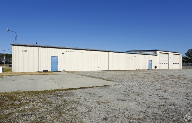
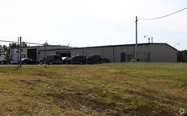
Property Detail
2307 Womble Brooks Rd E
3732-33-0348.000
2307 WOMBLE BROOKS RD E 3.00AC
Warehouse
Wilson
LI
North Carolina
B and X Area of moderate flood hazard, usually the area between the limits of the 100-year and 500-year floods.
3 AC
2025
Rocky Mount/Wilson
2026
Other Market Areas
000701
Wilson, NC
8,400 SF
NEARBY LISTINGS FOR SALE OR LEASE
DEMOGRAPHICS near 2307 Womble Brooks Rd E
1 mile
3 mile
5 mile
2025 Total Population
1,314
24,236
50,058
2030 Population
1,373
25,239
51,321
Pop Growth 2025-2030
+ 4.49%
+ 4.14%
+ 2.52%
Average Age
38
40
41
2025 Total Households
501
9,841
20,609
HH Growth 2025-2030
+ 4.39%
+ 4.22%
+ 2.61%
Median Household Inc
$33,791
$38,051
$46,824
Avg Household Size
2.40
2.30
2.30
2025 Avg HH Vehicles
1.00
1.00
2.00
Median Home Value
$79,910
$125,437
$218,093
Median Year Built
1980
1974
1981
Nearby Places
Map Layers
Map Styles
 Street
 Aerial
Layers
 Traffic
 Biking
Places
Listings with unknown addresses are not visible on the map
- Restaurants
- Banks
- Shops
- Fitness
- Groceries
PUBLIC TRANSPORTATION
COMMUTER RAIL
Wilson (Carolinian - Amtrak, Palmetto - Amtrak)
Drive
Walk
Distance
Wilson (Carolinian - Amtrak, Palmetto - Amtrak)
5 min
2.5 mi
Wilson (Carolinian - Amtrak, Palmetto - Amtrak)
Drive
Walk
Distance
Wilson (Carolinian - Amtrak, Palmetto - Amtrak)
5 min
2.5 mi
AIRPORT
Pitt-Greenville
Drive
Walk
Distance
Pitt-Greenville
47 min
38.3 mi
Freight Ports
Port of Morehead City
Drive
Walk
Distance
Port of Morehead City
169 min
119.1 mi
Nearby Properties
Address
Land Use
TOTAL SIZE
Lot Size
Zoning
Address
Land Use
TOTAL SIZE
Lot Size
Zoning
1,431 SF
197.40 AC
GC
Address
Land Use
TOTAL SIZE
Lot Size
Zoning
4,331 SF
34.44 AC
ICD
Address
Land Use
TOTAL SIZE
Lot Size
Zoning
39,025 SF
1.94 AC
CCMX
Address
Land Use
TOTAL SIZE
Lot Size
Zoning
6,704 SF
75.58 AC
ICD
Address
Land Use
TOTAL SIZE
Lot Size
Zoning
10,152 SF
29.71 AC
ICD
Address
Land Use
TOTAL SIZE
Lot Size
Zoning
15,717 SF
1.01 AC
CCMX
Address
Land Use
TOTAL SIZE
Lot Size
Zoning
47,843 SF
2.98 AC
GC
Address
Land Use
TOTAL SIZE
Lot Size
Zoning
90,035 SF
91.87 AC
ICD
Address
Land Use
TOTAL SIZE
Lot Size
Zoning
80,000 SF
101.30 AC
HI
Address
Land Use
TOTAL SIZE
Lot Size
Zoning
25,888 SF
73.36 AC
LI
Address
Land Use
TOTAL SIZE
Lot Size
Zoning
22,852 SF
1.95 AC
CCMX
Address
Land Use
TOTAL SIZE
Lot Size
Zoning
71,140 SF
6.63 AC
Address
Land Use
TOTAL SIZE
Lot Size
Zoning
75,622 SF
9.13 AC
ICD
Address
Land Use
TOTAL SIZE
Lot Size
Zoning
33,650 SF
35.52 AC
ICD
Address
Land Use
TOTAL SIZE
Lot Size
Zoning
6,836 SF
7.68 AC
NC
Address
Land Use
TOTAL SIZE
Lot Size
Zoning
20,705 SF
7.88 AC
GR6
Address
Land Use
TOTAL SIZE
Lot Size
Zoning
6,600 SF
707.94 AC
M2
Address
Land Use
TOTAL SIZE
Lot Size
Zoning
35,406 SF
2.91 AC
GR6
Address
Land Use
TOTAL SIZE
Lot Size
Zoning
7,552 SF
51.19 AC
HI
Address
Land Use
TOTAL SIZE
Lot Size
Zoning
41,651 SF
2.37 AC
CCMX
Address
Land Use
TOTAL SIZE
Lot Size
Zoning
63,788 SF
16.30 AC
ICD
Address
Land Use
TOTAL SIZE
Lot Size
Zoning
5,832 SF
50 AC
ICD
Address
Land Use
TOTAL SIZE
Lot Size
Zoning
60,620 SF
1.47 AC
CCMX
Address
Land Use
TOTAL SIZE
Lot Size
Zoning
129,404 SF
2.61 AC
HI
Address
Land Use
TOTAL SIZE
Lot Size
Zoning
13,798 SF
1.88 AC
NMX
Address
Land Use
TOTAL SIZE
Lot Size
Zoning
42,840 SF
1.78 AC
CCMX
Address
Land Use
TOTAL SIZE
Lot Size
Zoning
30,726 SF
5.71 AC
GR6
Address
Land Use
TOTAL SIZE
Lot Size
Zoning
4,416 SF
14.90 AC
RMX
Address
Land Use
TOTAL SIZE
Lot Size
Zoning
12,073 SF
5.37 AC
GC
Address
Land Use
TOTAL SIZE
Lot Size
Zoning
3,442 SF
11.59 AC
UR
The World's #1 Commercial Real Estate Marketplace
Connect with us
© 2026 CoStar Group
The information above has been obtained from sources believed reliable. While we do not doubt its accuracy we have not verified it and make no guarantee, warranty or representation about it. It is your responsibility to independently confirm its accuracy and completeness. Any projections, opinions, assumptions, or estimates used are for example only and do not represent the current or future performance of the property. The value of this transaction to you depends on tax and other factors which should be evaluated by your tax, financial, and legal advisors. You and your advisors should conduct a careful, independent investigation of the property to determine to your satisfaction the suitability of the property for your needs.