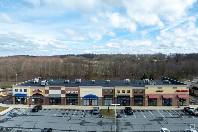
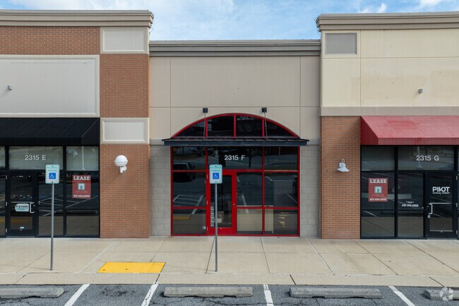
Property Record
2309 Hanover Pike, Hampstead, MD 21074

Property Detail
2309 Hanover Pike
08-026912
12.61 ACRES E/S HANOVER PIKE RESOLUTION #27
Communitycenter
Carroll
GENER
Maryland
B and X Area of moderate flood hazard, usually the area between the limits of the 100-year and 500-year floods.
12.61 AC
2025
Carroll County
2025
Baltimore
508103
Baltimore-Columbia-Towson, MD
6,808 SF
NEARBY LISTINGS FOR SALE OR LEASE
DEMOGRAPHICS near 2309 Hanover Pike
1 mile
3 mile
5 mile
2025 Total Population
1,044
16,983
27,895
2030 Population
1,060
17,220
28,182
Pop Growth 2025-2030
+ 1.53%
+ 1.40%
+ 1.03%
Average Age
42
42
42
2025 Total Households
383
6,345
10,359
HH Growth 2025-2030
+ 1.57%
+ 1.43%
+ 1.06%
Median Household Inc
$111,363
$111,043
$108,989
Avg Household Size
2.70
2.70
2.70
2025 Avg HH Vehicles
2.00
2.00
2.00
Median Home Value
$389,449
$374,598
$388,890
Median Year Built
1979
1983
1983
Nearby Places
Map Layers
Map Styles
 Street
 Aerial
Transit
 Traffic
 Biking
Places
Listings with unknown addresses are not visible on the map
- Restaurants
- Banks
- Shops
- Fitness
- Groceries
PUBLIC TRANSPORTATION
AIRPORT
Baltimore/Washington International Thurgood Marshall
Drive
Walk
Distance
Baltimore/Washington International Thurgood Marshall
56 min
37.5 mi
Freight Ports
Port of Baltimore
Drive
Walk
Distance
Port of Baltimore
56 min
37.2 mi
SALE & LEASE HISTORY
LISTING DATE
SALE/LEASE

Oct 09, 2025
For Lease
Nearby Properties
Address
Land Use
TOTAL SIZE
Lot Size
Zoning
Address
Land Use
TOTAL SIZE
Lot Size
Zoning
222,959 SF
91.88 AC
PUBLI
Address
Land Use
TOTAL SIZE
Lot Size
Zoning
1,034,020 SF
51.58 AC
I-1
Address
Land Use
TOTAL SIZE
Lot Size
Zoning
223,105 SF
21.16 AC
RESTR
Address
Land Use
TOTAL SIZE
Lot Size
Zoning
115,358 SF
26.99 AC
PUBLI
Address
Land Use
TOTAL SIZE
Lot Size
Zoning
72,000 SF
20.03 AC
CONSE
Address
Land Use
TOTAL SIZE
Lot Size
Zoning
164,630 SF
33.07 AC
C-3
Address
Land Use
TOTAL SIZE
Lot Size
Zoning
95,786 SF
10.11 AC
RESTR
Address
Land Use
TOTAL SIZE
Lot Size
Zoning
56,752 SF
5 AC
PUBLI
Address
Land Use
TOTAL SIZE
Lot Size
Zoning
62,082 SF
31.08 AC
CONSE
Address
Land Use
TOTAL SIZE
Lot Size
Zoning
19,004 SF
20 AC
R-100
Address
Land Use
TOTAL SIZE
Lot Size
Zoning
229.22 AC
PUBLI
Address
Land Use
TOTAL SIZE
Lot Size
Zoning
2,078 SF
2.09 AC
BL
Address
Land Use
TOTAL SIZE
Lot Size
Zoning
39,992 SF
19.57 AC
PUBLI
Address
Land Use
TOTAL SIZE
Lot Size
Zoning
2,440 SF
42.38 AC
PUBLI
Address
Land Use
TOTAL SIZE
Lot Size
Zoning
13,120 SF
3.15 AC
Address
Land Use
TOTAL SIZE
Lot Size
Zoning
3,000 SF
4.62 AC
I-1
Address
Land Use
TOTAL SIZE
Lot Size
Zoning
34,584 SF
6.02 AC
RESTR
Address
Land Use
TOTAL SIZE
Lot Size
Zoning
72,750 SF
7.09 AC
RESTR
Address
Land Use
TOTAL SIZE
Lot Size
Zoning
10,642 SF
2.30 AC
LOCAL
Address
Land Use
TOTAL SIZE
Lot Size
Zoning
52,108 SF
18.92 AC
AGRIC
Address
Land Use
TOTAL SIZE
Lot Size
Zoning
702 SF
34.80 AC
RESTR
Address
Land Use
TOTAL SIZE
Lot Size
Zoning
21,859 SF
2.92 AC
GENER
Address
Land Use
TOTAL SIZE
Lot Size
Zoning
260,550 SF
49.38 AC
HISTO
Address
Land Use
TOTAL SIZE
Lot Size
Zoning
52,824 SF
9.74 AC
GENER
Address
Land Use
TOTAL SIZE
Lot Size
Zoning
11,860 SF
1.64 AC
LOCAL
Address
Land Use
TOTAL SIZE
Lot Size
Zoning
7,332 SF
3 AC
R-200
Address
Land Use
TOTAL SIZE
Lot Size
Zoning
39.19 AC
RESTR
Address
Land Use
TOTAL SIZE
Lot Size
Zoning
13,657 SF
4.05 AC
PRIVA
Address
Land Use
TOTAL SIZE
Lot Size
Zoning
33,350 SF
3.50 AC
HISTO
The World's #1 Commercial Real Estate Marketplace
Connect with us
© 2026 CoStar Group
The information above has been obtained from sources believed reliable. While we do not doubt its accuracy we have not verified it and make no guarantee, warranty or representation about it. It is your responsibility to independently confirm its accuracy and completeness. Any projections, opinions, assumptions, or estimates used are for example only and do not represent the current or future performance of the property. The value of this transaction to you depends on tax and other factors which should be evaluated by your tax, financial, and legal advisors. You and your advisors should conduct a careful, independent investigation of the property to determine to your satisfaction the suitability of the property for your needs.