Property Record
231 Highway 211 Nw, Winder, GA 30680
NEARBY LISTINGS FOR SALE OR LEASE
Property Detail
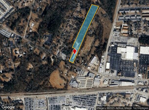
231 Highway 211 Nw
Atlanta-Sandy Springs-Roswell, GA
Roxeywood Park Unit One
XX064-104
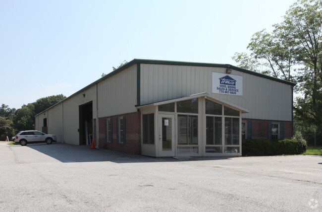
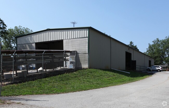
231 HIGHWAY 211 NW - TRIM CO VINYL SIDING
Warehouse
Barrow
X
Georgia
13013C0126D
res
2024
6.90 AC
2024
S Barrow
180205
Atlanta
7,000 SF
DEMOGRAPHICS near 231 Highway 211 Nw
1 Mile
3 Mile
5 Mile
2024 Total Population
4,844
27,683
52,098
2029 Population
5,656
32,439
61,040
Pop Growth 2024-2029
+ 16.76%
+ 17.18%
+ 17.16%
Average Age
37
38
37
2024 Total Households
1,787
9,808
17,953
HH Growth 2024-2029
+ 16.90%
+ 17.32%
+ 17.28%
Median Household Inc
$55,480
$59,248
$65,590
Avg Household Size
2.70
2.80
2.80
2024 Avg HH Vehicles
2.00
2.00
2.00
Median Home Value
$183,657
$193,793
$203,485
Median Year Built
1986
1993
1997
Nearby Places
Map Layers
Map Styles
 Street
 Aerial
- Restaurants
- Banks
- Shops
- Fitness
- Groceries
Nearby Properties
Address
Land Use
TOTAL SIZE
Lot Size
Zoning
Address
Land Use
TOTAL SIZE
Lot Size
Zoning
1,456 SF
1,732.80 AC
G
Address
Land Use
TOTAL SIZE
Lot Size
Zoning
165,737 SF
134.60 AC
G
Address
Land Use
TOTAL SIZE
Lot Size
Zoning
690,427 SF
156 AC
M-1
Address
Land Use
TOTAL SIZE
Lot Size
Zoning
105,850 SF
61 AC
G
Address
Land Use
TOTAL SIZE
Lot Size
Zoning
50,000 SF
29 AC
G
Address
Land Use
TOTAL SIZE
Lot Size
Zoning
89,684 SF
64.90 AC
B-2
Address
Land Use
TOTAL SIZE
Lot Size
Zoning
38,000 SF
362.40 AC
G,R-1A
Address
Land Use
TOTAL SIZE
Lot Size
Zoning
189,400 SF
24.80 AC
C-2
Address
Land Use
TOTAL SIZE
Lot Size
Zoning
233,462 SF
25.20 AC
C-2
Address
Land Use
TOTAL SIZE
Lot Size
Zoning
83,937 SF
17.80 AC
B-1
Address
Land Use
TOTAL SIZE
Lot Size
Zoning
60,540 SF
79.30 AC
AG
Address
Land Use
TOTAL SIZE
Lot Size
Zoning
107,399 SF
14.30 AC
B-1
Address
Land Use
TOTAL SIZE
Lot Size
Zoning
48,998 SF
15.50 AC
B-1
Address
Land Use
TOTAL SIZE
Lot Size
Zoning
24,188 SF
40.70 AC
M-1
Address
Land Use
TOTAL SIZE
Lot Size
Zoning
3,462 SF
10.10 AC
G,R-3
Address
Land Use
TOTAL SIZE
Lot Size
Zoning
4,210 SF
3.30 AC
G
Address
Land Use
TOTAL SIZE
Lot Size
Zoning
51,753 SF
9.20 AC
B-2,R-3
Address
Land Use
TOTAL SIZE
Lot Size
Zoning
4,405 SF
7.50 AC
B-1,R-1,R-
Address
Land Use
TOTAL SIZE
Lot Size
Zoning
14,800 SF
57.90 AC
M-1
Address
Land Use
TOTAL SIZE
Lot Size
Zoning
20,592 SF
66.10 AC
G
Address
Land Use
TOTAL SIZE
Lot Size
Zoning
69,285 SF
53.10 AC
M-2
Address
Land Use
TOTAL SIZE
Lot Size
Zoning
30,575 SF
7.30 AC
G,R-1A
Address
Land Use
TOTAL SIZE
Lot Size
Zoning
65.10 AC
PUD
Address
Land Use
TOTAL SIZE
Lot Size
Zoning
59,898 SF
38.90 AC
M-1
Address
Land Use
TOTAL SIZE
Lot Size
Zoning
76,768 SF
25 AC
R-1
Address
Land Use
TOTAL SIZE
Lot Size
Zoning
50,662 SF
6.20 AC
G
Address
Land Use
TOTAL SIZE
Lot Size
Zoning
7,000 SF
10.70 AC
G
Address
Land Use
TOTAL SIZE
Lot Size
Zoning
22,500 SF
10.50 AC
M-1
Address
Land Use
TOTAL SIZE
Lot Size
Zoning
3,116 SF
21 AC
G
Address
Land Use
TOTAL SIZE
Lot Size
Zoning
11,914 SF
6.90 AC
G,R-2,R-3
The World's #1 Commercial Real Estate Marketplace
Connect with us
© 2025 CoStar Group
The information above has been obtained from sources believed reliable. While we do not doubt its accuracy we have not verified it and make no guarantee, warranty or representation about it. It is your responsibility to independently confirm its accuracy and completeness. Any projections, opinions, assumptions, or estimates used are for example only and do not represent the current or future performance of the property. The value of this transaction to you depends on tax and other factors which should be evaluated by your tax, financial, and legal advisors. You and your advisors should conduct a careful, independent investigation of the property to determine to your satisfaction the suitability of the property for your needs.