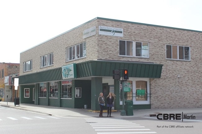
Property Record
231 Mac Ave, East Lansing, MI 48823

Current Lease Availabilities
Property Detail
231 Mac Ave
20-02-18-162-003
LOT 14 EXC S 53' 3 COLLEGE GROVE
Storebuilding
Ingham
B3
Michigan
B and X Area of moderate flood hazard, usually the area between the limits of the 100-year and 500-year floods.
14
2024
0.15 AC
2025
East Lansing
004100
West Michigan
11,232 SF
Lansing-East Lansing, MI
NEARBY LISTINGS FOR SALE OR LEASE
DEMOGRAPHICS near 231 Mac Ave
1 mile
3 mile
5 mile
2025 Total Population
31,730
91,092
175,151
2030 Population
33,589
94,907
180,452
Pop Growth 2025-2030
+ 5.86%
+ 4.19%
+ 3.03%
Average Age
27
33
36
2025 Total Households
9,474
36,573
73,669
HH Growth 2025-2030
+ 7.79%
+ 4.49%
+ 3.19%
Median Household Inc
$39,590
$50,023
$58,674
Avg Household Size
2.20
2.10
2.10
2025 Avg HH Vehicles
2.00
2.00
2.00
Median Home Value
$277,764
$228,332
$193,499
Median Year Built
1980
1977
1972
Nearby Places
Map Layers
Map Styles
 Street
 Aerial
Layers
 Traffic
 Biking
Places
Listings with unknown addresses are not visible on the map
- Restaurants
- Banks
- Shops
- Fitness
- Groceries
PUBLIC TRANSPORTATION
COMMUTER RAIL
East Lansing Amtrak Station (Blue Water - Amtrak)
Drive
Walk
Distance
East Lansing Amtrak Station (Blue Water - Amtrak)
6 min
1.9 mi
AIRPORT
Capital Region International
Drive
Walk
Distance
Capital Region International
15 min
7.1 mi
Freight Ports
Port of Toledo
Drive
Walk
Distance
Port of Toledo
147 min
114.6 mi
Nearby Properties
Address
Land Use
TOTAL SIZE
Lot Size
Zoning
Address
Land Use
TOTAL SIZE
Lot Size
Zoning
312,651 SF
37.50 AC
D-1 PRO
Address
Land Use
TOTAL SIZE
Lot Size
Zoning
42,875 SF
35 AC
PD
Address
Land Use
TOTAL SIZE
Lot Size
Zoning
66,818 SF
0.99 AC
EV
Address
Land Use
TOTAL SIZE
Lot Size
Zoning
7,579 SF
83.53 AC
PD
Address
Land Use
TOTAL SIZE
Lot Size
Zoning
42,875 SF
28.77 AC
Address
Land Use
TOTAL SIZE
Lot Size
Zoning
14,304 SF
3.37 AC
MIXED Z
Address
Land Use
TOTAL SIZE
Lot Size
Zoning
49,959 SF
15.71 AC
RP
Address
Land Use
TOTAL SIZE
Lot Size
Zoning
222,869 SF
0.10 AC
B3
Address
Land Use
TOTAL SIZE
Lot Size
Zoning
98,513 SF
7.86 AC
C-2
Address
Land Use
TOTAL SIZE
Lot Size
Zoning
274,720 SF
10.55 AC
Address
Land Use
TOTAL SIZE
Lot Size
Zoning
73,179 SF
58.17 AC
RM14
Address
Land Use
TOTAL SIZE
Lot Size
Zoning
12,435 SF
0.52 AC
B3
Address
Land Use
TOTAL SIZE
Lot Size
Zoning
63,461 SF
32 AC
F COMM
Address
Land Use
TOTAL SIZE
Lot Size
Zoning
13.13 AC
Address
Land Use
TOTAL SIZE
Lot Size
Zoning
66.43 AC
Address
Land Use
TOTAL SIZE
Lot Size
Zoning
179,376 SF
6.03 AC
RM32
Address
Land Use
TOTAL SIZE
Lot Size
Zoning
16,466 SF
14.82 AC
DEVELOPMEN
Address
Land Use
TOTAL SIZE
Lot Size
Zoning
51,122 SF
9.05 AC
RAA
Address
Land Use
TOTAL SIZE
Lot Size
Zoning
195,094 SF
1.89 AC
Address
Land Use
TOTAL SIZE
Lot Size
Zoning
19,035 SF
12.32 AC
RM08
Address
Land Use
TOTAL SIZE
Lot Size
Zoning
20,438 SF
17.81 AC
DEVELOPMEN
Address
Land Use
TOTAL SIZE
Lot Size
Zoning
188,175 SF
4.37 AC
EV
Address
Land Use
TOTAL SIZE
Lot Size
Zoning
215,335 SF
38.10 AC
RM08
Address
Land Use
TOTAL SIZE
Lot Size
Zoning
300,760 SF
27.22 AC
RM08
Address
Land Use
TOTAL SIZE
Lot Size
Zoning
129,030 SF
RP
Address
Land Use
TOTAL SIZE
Lot Size
Zoning
61,198 SF
13.10 AC
C-2
Address
Land Use
TOTAL SIZE
Lot Size
Zoning
183,047 SF
24.36 AC
B4
Address
Land Use
TOTAL SIZE
Lot Size
Zoning
35,523 SF
6.23 AC
C-2
Address
Land Use
TOTAL SIZE
Lot Size
Zoning
131,234 SF
2.49 AC
Address
Land Use
TOTAL SIZE
Lot Size
Zoning
9,628 SF
1.86 AC
B2
The World's #1 Commercial Real Estate Marketplace
Connect with us
© 2026 CoStar Group
The information above has been obtained from sources believed reliable. While we do not doubt its accuracy we have not verified it and make no guarantee, warranty or representation about it. It is your responsibility to independently confirm its accuracy and completeness. Any projections, opinions, assumptions, or estimates used are for example only and do not represent the current or future performance of the property. The value of this transaction to you depends on tax and other factors which should be evaluated by your tax, financial, and legal advisors. You and your advisors should conduct a careful, independent investigation of the property to determine to your satisfaction the suitability of the property for your needs.