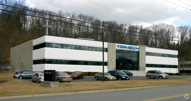
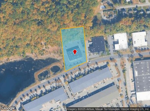
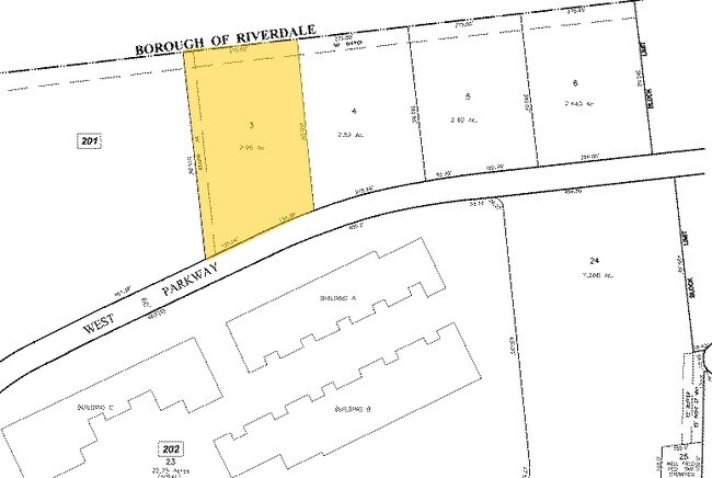
Property Record
231 W Parkway, Pompton Plains, NJ 07444
NEARBY LISTINGS FOR SALE OR LEASE
Property Detail
231 W Parkway
Newark, NJ-PA
West Park Sec 1A
31-00201-0000-00003
Morris
Medicalbuilding
New Jersey
X
3
34027C0181F
2.97 AC
2024
Route 23/I-287
2025
Northern New Jersey
040301
DEMOGRAPHICS near 231 W Parkway
1 Mile
3 Mile
5 Mile
2024 Total Population
7,144
62,425
124,275
2029 Population
7,184
62,179
123,696
Pop Growth 2024-2029
+ 0.56%
(0.39%)
(0.47%)
Average Age
49
44
44
2024 Total Households
3,194
23,548
46,368
HH Growth 2024-2029
+ 0.16%
(0.55%)
(0.63%)
Median Household Inc
$111,728
$118,073
$119,444
Avg Household Size
2.20
2.60
2.60
2024 Avg HH Vehicles
2.00
2.00
2.00
Median Home Value
$467,380
$441,192
$463,859
Median Year Built
1991
1964
1966
Nearby Places
- Restaurants
- Banks
- Shops
- Fitness
- Groceries
PUBLIC TRANSPORTATION
COMMUTER RAIL
Lincoln Park (Montclair-Boonton Line - NJ Transit Commuter Rail (NJ Transit))
DRIVE
WALK
Distance
Lincoln Park (Montclair-Boonton Line - NJ Transit Commuter Rail (NJ Transit))
10 min
4.3 mi
Towaco (Montclair-Boonton Line - NJ Transit Commuter Rail (NJ Transit))
DRIVE
WALK
Distance
Towaco (Montclair-Boonton Line - NJ Transit Commuter Rail (NJ Transit))
11 min
5.6 mi
AIRPORT
Newark Liberty International
DRIVE
WALK
Distance
Newark Liberty International
37 min
28.6 mi
LaGuardia
DRIVE
WALK
Distance
LaGuardia
47 min
36.7 mi
Freight Ports
Port Newark Container Terminal
DRIVE
WALK
Distance
Port Newark Container Terminal
1 min
21.8 mi
Nearby Properties
Address
Land Use
TOTAL SIZE
Lot Size
Zoning
Address
Land Use
TOTAL SIZE
Lot Size
Zoning
143.16 AC
PUD
Address
Land Use
TOTAL SIZE
Lot Size
Zoning
21.99 AC
H
Address
Land Use
TOTAL SIZE
Lot Size
Zoning
10.88 AC
Address
Land Use
TOTAL SIZE
Lot Size
Zoning
18.76 AC
C-3
Address
Land Use
TOTAL SIZE
Lot Size
Zoning
264,080 SF
44.44 AC
HB
Address
Land Use
TOTAL SIZE
Lot Size
Zoning
32.21 AC
R-15
Address
Land Use
TOTAL SIZE
Lot Size
Zoning
5,880 SF
17.46 AC
I
Address
Land Use
TOTAL SIZE
Lot Size
Zoning
334,755 SF
107.89 AC
Address
Land Use
TOTAL SIZE
Lot Size
Zoning
49,925 SF
4.08 AC
R-4
Address
Land Use
TOTAL SIZE
Lot Size
Zoning
41.71 AC
C-4
Address
Land Use
TOTAL SIZE
Lot Size
Zoning
41,791 SF
4.82 AC
HC
Address
Land Use
TOTAL SIZE
Lot Size
Zoning
231.26 AC
PRC
Address
Land Use
TOTAL SIZE
Lot Size
Zoning
25,064 SF
14.53 AC
HB
Address
Land Use
TOTAL SIZE
Lot Size
Zoning
131,306 SF
14.40 AC
HB
Address
Land Use
TOTAL SIZE
Lot Size
Zoning
9.08 AC
H-C
Address
Land Use
TOTAL SIZE
Lot Size
Zoning
103,603 SF
12.12 AC
LI
Address
Land Use
TOTAL SIZE
Lot Size
Zoning
7.58 AC
R-4
Address
Land Use
TOTAL SIZE
Lot Size
Zoning
9.28 AC
R-11
Address
Land Use
TOTAL SIZE
Lot Size
Zoning
10.07 AC
R-15
Address
Land Use
TOTAL SIZE
Lot Size
Zoning
82,022 SF
6.09 AC
RC
Address
Land Use
TOTAL SIZE
Lot Size
Zoning
Address
Land Use
TOTAL SIZE
Lot Size
Zoning
109,848 SF
14.01 AC
HB
Address
Land Use
TOTAL SIZE
Lot Size
Zoning
9.13 AC
R-G
Address
Land Use
TOTAL SIZE
Lot Size
Zoning
12.24 AC
H-C
Address
Land Use
TOTAL SIZE
Lot Size
Zoning
6.30 AC
I-2
Address
Land Use
TOTAL SIZE
Lot Size
Zoning
13.72 AC
RO
Address
Land Use
TOTAL SIZE
Lot Size
Zoning
8,978 SF
7.04 AC
R-4
Address
Land Use
TOTAL SIZE
Lot Size
Zoning
634 SF
14.76 AC
H
Address
Land Use
TOTAL SIZE
Lot Size
Zoning
6.95 AC
I-2
Address
Land Use
TOTAL SIZE
Lot Size
Zoning
2.93 AC
B-5
The World's #1 Commercial Real Estate Marketplace
Connect with us
© 2025 CoStar Group
The information above has been obtained from sources believed reliable. While we do not doubt its accuracy we have not verified it and make no guarantee, warranty or representation about it. It is your responsibility to independently confirm its accuracy and completeness. Any projections, opinions, assumptions, or estimates used are for example only and do not represent the current or future performance of the property. The value of this transaction to you depends on tax and other factors which should be evaluated by your tax, financial, and legal advisors. You and your advisors should conduct a careful, independent investigation of the property to determine to your satisfaction the suitability of the property for your needs.