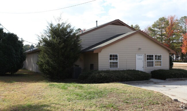
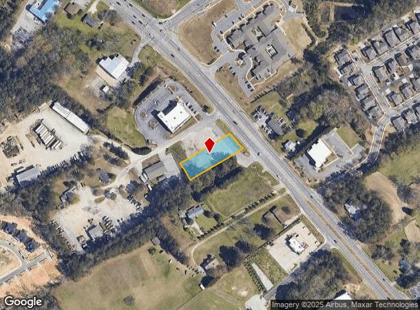
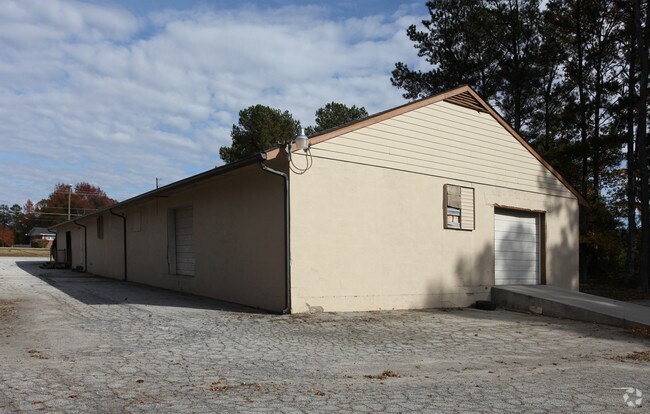
Property Record
2311 Loganville Hwy, Grayson, GA 30017

NEARBY LISTINGS FOR SALE OR LEASE
Property Detail
2311 Loganville Hwy
Atlanta-Sandy Springs-Roswell, GA
Ramco Properties Llc
5-135-021
GA HWY 20
Commercialacreage
Gwinnett
X
Georgia
13135C0119F
1,2
2025
0.62 AC
2025
GA-316/Lawrenceville
050746
Atlanta
DEMOGRAPHICS near 2311 Loganville Hwy
1 Mile
3 Mile
5 Mile
2024 Total Population
5,879
54,299
160,421
2029 Population
6,184
57,150
168,653
Pop Growth 2024-2029
+ 5.19%
+ 5.25%
+ 5.13%
Average Age
39
38
38
2024 Total Households
1,836
17,153
50,614
HH Growth 2024-2029
+ 5.28%
+ 5.33%
+ 5.26%
Median Household Inc
$121,804
$96,579
$87,242
Avg Household Size
3.20
3.10
3.10
2024 Avg HH Vehicles
2.00
2.00
2.00
Median Home Value
$360,416
$328,132
$313,873
Median Year Built
2006
2002
1999
Nearby Places
Map Layers
Map Styles
 Street
 Aerial
- Restaurants
- Banks
- Shops
- Fitness
- Groceries
PUBLIC TRANSPORTATION
AIRPORT
Hartsfield - Jackson Atlanta International
DRIVE
WALK
Distance
Hartsfield - Jackson Atlanta International
59 min
38.3 mi
Nearby Properties
Address
Land Use
TOTAL SIZE
Lot Size
Zoning
Address
Land Use
TOTAL SIZE
Lot Size
Zoning
484,262 SF
34.27 AC
RM
Address
Land Use
TOTAL SIZE
Lot Size
Zoning
352,924 SF
86.43 AC
R100
Address
Land Use
TOTAL SIZE
Lot Size
Zoning
455,030 SF
80.40 AC
R100
Address
Land Use
TOTAL SIZE
Lot Size
Zoning
702.83 AC
R100
Address
Land Use
TOTAL SIZE
Lot Size
Zoning
360,279 SF
13.16 AC
RM24
Address
Land Use
TOTAL SIZE
Lot Size
Zoning
349,060 SF
59.85 AC
R100
Address
Land Use
TOTAL SIZE
Lot Size
Zoning
221,082 SF
12.90 AC
RM24
Address
Land Use
TOTAL SIZE
Lot Size
Zoning
194,295 SF
36.59 AC
R100
Address
Land Use
TOTAL SIZE
Lot Size
Zoning
222,622 SF
49.17 AC
R100
Address
Land Use
TOTAL SIZE
Lot Size
Zoning
145,681 SF
49.84 AC
RA200
Address
Land Use
TOTAL SIZE
Lot Size
Zoning
309,156 SF
17.39 AC
OI
Address
Land Use
TOTAL SIZE
Lot Size
Zoning
59,949 SF
71.12 AC
C1
Address
Land Use
TOTAL SIZE
Lot Size
Zoning
4,408 SF
148.92 AC
R100
Address
Land Use
TOTAL SIZE
Lot Size
Zoning
186,309 SF
15.53 AC
RM
Address
Land Use
TOTAL SIZE
Lot Size
Zoning
101,193 SF
5.34 AC
C2
Address
Land Use
TOTAL SIZE
Lot Size
Zoning
107,829 SF
7.82 AC
RM
Address
Land Use
TOTAL SIZE
Lot Size
Zoning
87,365 SF
11.32 AC
BG
Address
Land Use
TOTAL SIZE
Lot Size
Zoning
93,046 SF
82 AC
R100
Address
Land Use
TOTAL SIZE
Lot Size
Zoning
111,920 SF
8.20 AC
C2
Address
Land Use
TOTAL SIZE
Lot Size
Zoning
119,600 SF
1.33 AC
C2
Address
Land Use
TOTAL SIZE
Lot Size
Zoning
112,640 SF
5.17 AC
C2
Address
Land Use
TOTAL SIZE
Lot Size
Zoning
91,131 SF
15.60 AC
C2
Address
Land Use
TOTAL SIZE
Lot Size
Zoning
79,276 SF
9.08 AC
C2
Address
Land Use
TOTAL SIZE
Lot Size
Zoning
105,453 SF
14.57 AC
OI
Address
Land Use
TOTAL SIZE
Lot Size
Zoning
105,840 SF
2.66 AC
C2
Address
Land Use
TOTAL SIZE
Lot Size
Zoning
50,623 SF
18.47 AC
R100
Address
Land Use
TOTAL SIZE
Lot Size
Zoning
24,735 SF
8.27 AC
BG
Address
Land Use
TOTAL SIZE
Lot Size
Zoning
37,246 SF
13.64 AC
RA200
Address
Land Use
TOTAL SIZE
Lot Size
Zoning
65,747 SF
10.91 AC
R100
Address
Land Use
TOTAL SIZE
Lot Size
Zoning
83,286 SF
13.64 AC
C2
The World's #1 Commercial Real Estate Marketplace
Connect with us
© 2026 CoStar Group
The information above has been obtained from sources believed reliable. While we do not doubt its accuracy we have not verified it and make no guarantee, warranty or representation about it. It is your responsibility to independently confirm its accuracy and completeness. Any projections, opinions, assumptions, or estimates used are for example only and do not represent the current or future performance of the property. The value of this transaction to you depends on tax and other factors which should be evaluated by your tax, financial, and legal advisors. You and your advisors should conduct a careful, independent investigation of the property to determine to your satisfaction the suitability of the property for your needs.