Property Record
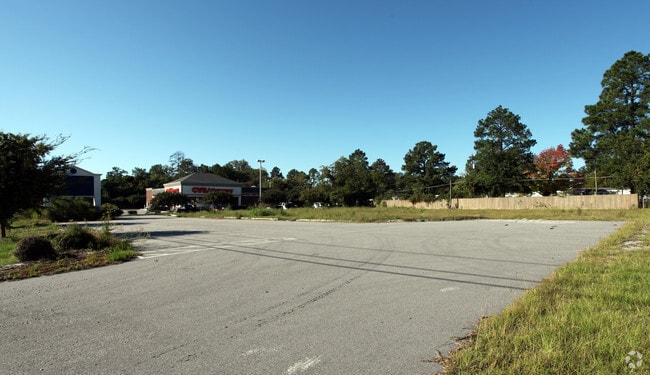
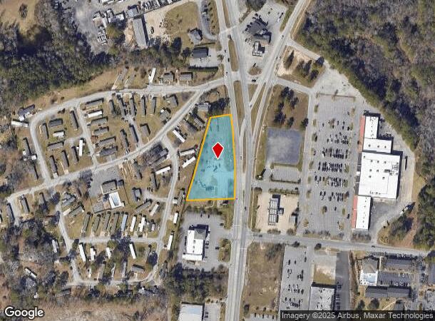
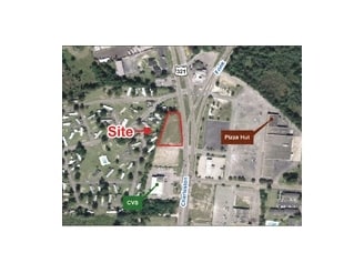
2312 Charleston Hwy, Cayce, SC 29033
NEARBY LISTINGS FOR SALE OR LEASE
Property Detail
2312 Charleston Hwy
Columbia, SC
W E Knotts
005757-02-008
TRACTS 3 & 3-A
Commercialacreage
Lexington
X
South Carolina
45063C0279J
1.22 AC
0
Cayce/West Columbia
2024
Columbia
020604
DEMOGRAPHICS near 2312 Charleston Hwy
1 Mile
3 Mile
5 Mile
2024 Total Population
3,637
24,925
95,369
2029 Population
3,953
27,269
101,897
Pop Growth 2024-2029
+ 8.69%
+ 9.40%
+ 6.84%
Average Age
41
41
36
2024 Total Households
1,564
11,261
40,732
HH Growth 2024-2029
+ 8.82%
+ 9.60%
+ 7.20%
Median Household Inc
$52,658
$54,157
$50,070
Avg Household Size
2.20
2.20
2.10
2024 Avg HH Vehicles
2.00
2.00
2.00
Median Home Value
$126,425
$147,242
$159,954
Median Year Built
1973
1970
1978
Nearby Places
- Restaurants
- Banks
- Shops
- Fitness
- Groceries
PUBLIC TRANSPORTATION
COMMUTER RAIL
Columbia Amtrak Station (Silver Star - Amtrak)
DRIVE
WALK
Distance
Columbia Amtrak Station (Silver Star - Amtrak)
10 min
5.5 mi
AIRPORT
Columbia Metro
DRIVE
WALK
Distance
Columbia Metro
16 min
7.3 mi
Freight Ports
North Charleston Terminal
DRIVE
WALK
Distance
North Charleston Terminal
112 min
99.9 mi
SALE & LEASE HISTORY
LISTING DATE
SALE/LEASE

May 15, 2018
For Sale
Nearby Properties
Address
Land Use
TOTAL SIZE
Lot Size
Zoning
Address
Land Use
TOTAL SIZE
Lot Size
Zoning
3,614 SF
1,444.32 AC
ID
Address
Land Use
TOTAL SIZE
Lot Size
Zoning
466,400 SF
52.42 AC
ID
Address
Land Use
TOTAL SIZE
Lot Size
Zoning
4,586 SF
19.15 AC
Address
Land Use
TOTAL SIZE
Lot Size
Zoning
1,218 SF
8.99 AC
RG
Address
Land Use
TOTAL SIZE
Lot Size
Zoning
1,924 SF
12.27 AC
R4
Address
Land Use
TOTAL SIZE
Lot Size
Zoning
297,500 SF
20.26 AC
ID
Address
Land Use
TOTAL SIZE
Lot Size
Zoning
8,118 SF
10.98 AC
RG
Address
Land Use
TOTAL SIZE
Lot Size
Zoning
222,557 SF
26.90 AC
ID
Address
Land Use
TOTAL SIZE
Lot Size
Zoning
180,000 SF
27.57 AC
ID
Address
Land Use
TOTAL SIZE
Lot Size
Zoning
10,304 SF
11.89 AC
R1
Address
Land Use
TOTAL SIZE
Lot Size
Zoning
181,440 SF
10.69 AC
ID
Address
Land Use
TOTAL SIZE
Lot Size
Zoning
5,091 SF
13.06 AC
RG
Address
Land Use
TOTAL SIZE
Lot Size
Zoning
107,890 SF
21.99 AC
C2
Address
Land Use
TOTAL SIZE
Lot Size
Zoning
9,800 SF
13.52 AC
ID
Address
Land Use
TOTAL SIZE
Lot Size
Zoning
5,502 SF
16.15 AC
ID
Address
Land Use
TOTAL SIZE
Lot Size
Zoning
318,309 SF
33.51 AC
ID
Address
Land Use
TOTAL SIZE
Lot Size
Zoning
21,424 SF
7.77 AC
HI
Address
Land Use
TOTAL SIZE
Lot Size
Zoning
200,000 SF
10.58 AC
ID
Address
Land Use
TOTAL SIZE
Lot Size
Zoning
61,012 SF
5.34 AC
Address
Land Use
TOTAL SIZE
Lot Size
Zoning
200,000 SF
9.66 AC
ID
Address
Land Use
TOTAL SIZE
Lot Size
Zoning
41,860 SF
5.67 AC
C3
Address
Land Use
TOTAL SIZE
Lot Size
Zoning
180,000 SF
12.48 AC
ID
Address
Land Use
TOTAL SIZE
Lot Size
Zoning
279,568 SF
11.38 AC
ID
Address
Land Use
TOTAL SIZE
Lot Size
Zoning
44,352 SF
7.55 AC
D1
Address
Land Use
TOTAL SIZE
Lot Size
Zoning
254,399 SF
49.79 AC
ID
Address
Land Use
TOTAL SIZE
Lot Size
Zoning
147,166 SF
18.27 AC
ID
Address
Land Use
TOTAL SIZE
Lot Size
Zoning
202,029 SF
21.13 AC
ID
Address
Land Use
TOTAL SIZE
Lot Size
Zoning
35.70 AC
Address
Land Use
TOTAL SIZE
Lot Size
Zoning
215,770 SF
24.51 AC
Address
Land Use
TOTAL SIZE
Lot Size
Zoning
50,400 SF
11 AC
ID
The World's #1 Commercial Real Estate Marketplace
Connect with us
© 2025 CoStar Group
The information above has been obtained from sources believed reliable. While we do not doubt its accuracy we have not verified it and make no guarantee, warranty or representation about it. It is your responsibility to independently confirm its accuracy and completeness. Any projections, opinions, assumptions, or estimates used are for example only and do not represent the current or future performance of the property. The value of this transaction to you depends on tax and other factors which should be evaluated by your tax, financial, and legal advisors. You and your advisors should conduct a careful, independent investigation of the property to determine to your satisfaction the suitability of the property for your needs.