Property Record
2312 Mcdonald Ave, Ruston, LA 71270
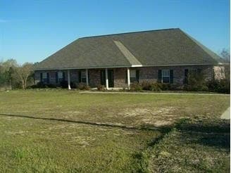

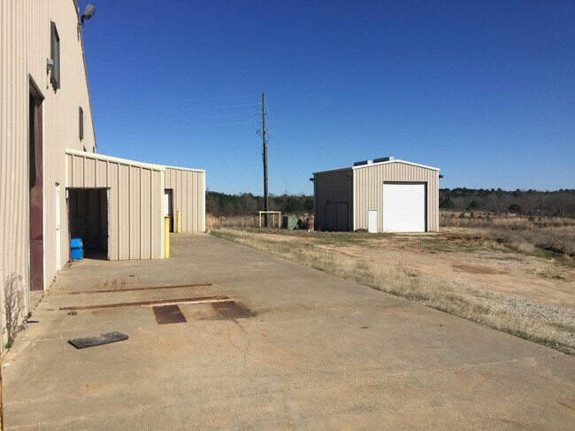
Property Detail
2312 Mcdonald Ave
38393
SEC 19-18-2: A CERTAIN 500 +/- ACRE TR OR PARCEL OF LAND SIT IN THE E/2 OF SE SEC 19-18-2 MORE PARTICULARLY DESC AS FOLLOWS:
Officebuilding
Lincoln
B and X Area of moderate flood hazard, usually the area between the limits of the 100-year and 500-year floods.
Louisiana
2025
5 AC
2025
Louisiana North Area
960600
Other Market Areas
2,624 SF
Ruston, LA
NEARBY LISTINGS FOR SALE OR LEASE
-
-
View all Ruston listings for sale on LoopNet.com
DEMOGRAPHICS near 2312 Mcdonald Ave
1 mile
3 mile
5 mile
2025 Total Population
1,789
16,984
29,495
2030 Population
1,783
16,878
29,449
Pop Growth 2025-2030
(0.34%)
(0.62%)
(0.16%)
Average Age
38
35
35
2025 Total Households
755
6,861
11,389
HH Growth 2025-2030
(0.26%)
(0.64%)
(0.13%)
Median Household Inc
$30,317
$32,897
$36,407
Avg Household Size
2.20
2.30
2.30
2025 Avg HH Vehicles
2.00
2.00
2.00
Median Home Value
$95,744
$186,067
$222,375
Median Year Built
1977
1983
1986
Nearby Places
Map Layers
Map Styles
 Street
 Aerial
Layers
 Traffic
 Biking
Places
Listings with unknown addresses are not visible on the map
- Restaurants
- Banks
- Shops
- Fitness
- Groceries
SALE & LEASE HISTORY
LISTING DATE
SALE/LEASE

Nov 02, 2016
For Sale
May 13, 2020
For Sale
Nearby Properties
Address
Land Use
TOTAL SIZE
Lot Size
Zoning
Address
Land Use
TOTAL SIZE
Lot Size
Zoning
225,000 SF
30 AC
Address
Land Use
TOTAL SIZE
Lot Size
Zoning
100,000 SF
Address
Land Use
TOTAL SIZE
Lot Size
Zoning
155,626 SF
13.18 AC
Address
Land Use
TOTAL SIZE
Lot Size
Zoning
105,290 SF
11.12 AC
Address
Land Use
TOTAL SIZE
Lot Size
Zoning
206,447 SF
Address
Land Use
TOTAL SIZE
Lot Size
Zoning
17,028 SF
12.28 AC
Address
Land Use
TOTAL SIZE
Lot Size
Zoning
264,355 SF
20.26 AC
Address
Land Use
TOTAL SIZE
Lot Size
Zoning
25,184 SF
12.54 AC
Address
Land Use
TOTAL SIZE
Lot Size
Zoning
138,249 SF
4.89 AC
Address
Land Use
TOTAL SIZE
Lot Size
Zoning
66,930 SF
7.80 AC
Address
Land Use
TOTAL SIZE
Lot Size
Zoning
31,716 SF
4.99 AC
Address
Land Use
TOTAL SIZE
Lot Size
Zoning
110,675 SF
15.14 AC
Address
Land Use
TOTAL SIZE
Lot Size
Zoning
55,929 SF
3.35 AC
Address
Land Use
TOTAL SIZE
Lot Size
Zoning
88,229 SF
6.44 AC
Address
Land Use
TOTAL SIZE
Lot Size
Zoning
17,418 SF
11.16 AC
Address
Land Use
TOTAL SIZE
Lot Size
Zoning
24,348 SF
4.60 AC
Address
Land Use
TOTAL SIZE
Lot Size
Zoning
33,140 SF
2.79 AC
Address
Land Use
TOTAL SIZE
Lot Size
Zoning
56,560 SF
2.94 AC
Address
Land Use
TOTAL SIZE
Lot Size
Zoning
72,169 SF
19.84 AC
Address
Land Use
TOTAL SIZE
Lot Size
Zoning
52,824 SF
2.16 AC
Address
Land Use
TOTAL SIZE
Lot Size
Zoning
58,868 SF
6.46 AC
Address
Land Use
TOTAL SIZE
Lot Size
Zoning
43,738 SF
6.92 AC
Address
Land Use
TOTAL SIZE
Lot Size
Zoning
31,938 SF
9.36 AC
Address
Land Use
TOTAL SIZE
Lot Size
Zoning
51,976 SF
2.31 AC
Address
Land Use
TOTAL SIZE
Lot Size
Zoning
34,414 SF
3.87 AC
Address
Land Use
TOTAL SIZE
Lot Size
Zoning
42,885 SF
19.48 AC
Address
Land Use
TOTAL SIZE
Lot Size
Zoning
42,672 SF
3.30 AC
Address
Land Use
TOTAL SIZE
Lot Size
Zoning
45,984 SF
2.15 AC
Address
Land Use
TOTAL SIZE
Lot Size
Zoning
140,000 SF
10.31 AC
Address
Land Use
TOTAL SIZE
Lot Size
Zoning
14,384 SF
2.07 AC
The World's #1 Commercial Real Estate Marketplace
Connect with us
© 2026 CoStar Group
The information above has been obtained from sources believed reliable. While we do not doubt its accuracy we have not verified it and make no guarantee, warranty or representation about it. It is your responsibility to independently confirm its accuracy and completeness. Any projections, opinions, assumptions, or estimates used are for example only and do not represent the current or future performance of the property. The value of this transaction to you depends on tax and other factors which should be evaluated by your tax, financial, and legal advisors. You and your advisors should conduct a careful, independent investigation of the property to determine to your satisfaction the suitability of the property for your needs.