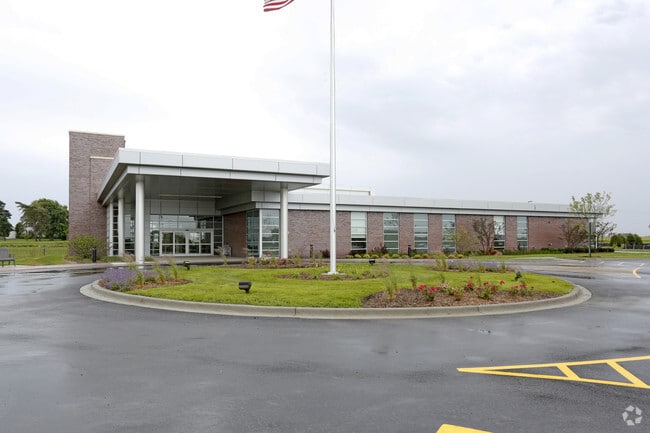
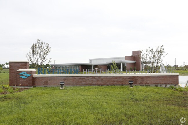
Property Record
23120 S La Grange Rd, Frankfort, IL 60423

NEARBY LISTINGS FOR SALE OR LEASE
Property Detail
23120 S La Grange Rd
Chicago-Naperville-Elgin, IL-IN-WI
Riverside Pud
18-13-06-202-020
LOT 1 IN RIVERSIDE PUD, BEING A SUB OF PRT OF THE NE1/4 OF SEC 6, PRT OF THE NW1/4 OF SEC 5, T34N-R12E, LYG N S OF THE IBL.
Commercialnec
Will
X
Illinois
17197C0310G
1
2024
18.65 AC
2024
Joliet/Central Will
883507
Chicago
DEMOGRAPHICS near 23120 S La Grange Rd
1 Mile
3 Mile
5 Mile
2024 Total Population
3,487
19,808
65,459
2029 Population
3,503
19,933
65,882
Pop Growth 2024-2029
+ 0.46%
+ 0.63%
+ 0.65%
Average Age
42
41
40
2024 Total Households
1,186
6,624
22,262
HH Growth 2024-2029
+ 0.25%
+ 0.57%
+ 0.52%
Median Household Inc
$127,262
$131,780
$123,265
Avg Household Size
2.90
3.00
2.90
2024 Avg HH Vehicles
2.00
2.00
2.00
Median Home Value
$445,957
$416,667
$373,618
Median Year Built
2003
2001
1996
Nearby Places
Map Layers
Map Styles
 Street
 Aerial
- Restaurants
- Banks
- Shops
- Fitness
- Groceries
PUBLIC TRANSPORTATION
COMMUTER RAIL
Mokena/Front Street Station (Rock Island District Line - Northeast Illinois Regional Commuter Railroad (Metra))
DRIVE
WALK
Distance
Mokena/Front Street Station (Rock Island District Line - Northeast Illinois Regional Commuter Railroad (Metra))
10 min
4.6 mi
New Lenox Laraway Road (SouthWest Service - Northeast Illinois Regional Commuter Railroad (Metra))
DRIVE
WALK
Distance
New Lenox Laraway Road (SouthWest Service - Northeast Illinois Regional Commuter Railroad (Metra))
10 min
5.0 mi
AIRPORT
Chicago Midway International
DRIVE
WALK
Distance
Chicago Midway International
46 min
28.4 mi
Freight Ports
Port Milwaukee
DRIVE
WALK
Distance
Port Milwaukee
148 min
115.6 mi
Nearby Properties
Address
Land Use
TOTAL SIZE
Lot Size
Zoning
Address
Land Use
TOTAL SIZE
Lot Size
Zoning
11.40 AC
Address
Land Use
TOTAL SIZE
Lot Size
Zoning
570,796 SF
39.64 AC
Address
Land Use
TOTAL SIZE
Lot Size
Zoning
17.19 AC
Address
Land Use
TOTAL SIZE
Lot Size
Zoning
103,663 SF
13.06 AC
Address
Land Use
TOTAL SIZE
Lot Size
Zoning
209,485 SF
9.79 AC
Address
Land Use
TOTAL SIZE
Lot Size
Zoning
3.73 AC
Address
Land Use
TOTAL SIZE
Lot Size
Zoning
85,037 SF
8.21 AC
Address
Land Use
TOTAL SIZE
Lot Size
Zoning
26,240 SF
2.89 AC
Address
Land Use
TOTAL SIZE
Lot Size
Zoning
6.76 AC
Address
Land Use
TOTAL SIZE
Lot Size
Zoning
107,631 SF
6.82 AC
Address
Land Use
TOTAL SIZE
Lot Size
Zoning
18,824 SF
9.56 AC
Address
Land Use
TOTAL SIZE
Lot Size
Zoning
19,238 SF
2.50 AC
Address
Land Use
TOTAL SIZE
Lot Size
Zoning
3.66 AC
Address
Land Use
TOTAL SIZE
Lot Size
Zoning
87,360 SF
9.53 AC
Address
Land Use
TOTAL SIZE
Lot Size
Zoning
26.14 AC
Address
Land Use
TOTAL SIZE
Lot Size
Zoning
51,900 SF
4.12 AC
Address
Land Use
TOTAL SIZE
Lot Size
Zoning
33.32 AC
Address
Land Use
TOTAL SIZE
Lot Size
Zoning
4,100 SF
37.58 AC
Address
Land Use
TOTAL SIZE
Lot Size
Zoning
Address
Land Use
TOTAL SIZE
Lot Size
Zoning
9,587 SF
1.64 AC
Address
Land Use
TOTAL SIZE
Lot Size
Zoning
14,430 SF
5.37 AC
Address
Land Use
TOTAL SIZE
Lot Size
Zoning
1.35 AC
Address
Land Use
TOTAL SIZE
Lot Size
Zoning
6,510 SF
3.41 AC
Address
Land Use
TOTAL SIZE
Lot Size
Zoning
4.04 AC
Address
Land Use
TOTAL SIZE
Lot Size
Zoning
17,600 SF
2.30 AC
Address
Land Use
TOTAL SIZE
Lot Size
Zoning
57,934 SF
10.56 AC
Address
Land Use
TOTAL SIZE
Lot Size
Zoning
14,560 SF
1.89 AC
Address
Land Use
TOTAL SIZE
Lot Size
Zoning
Address
Land Use
TOTAL SIZE
Lot Size
Zoning
1.66 AC
The World's #1 Commercial Real Estate Marketplace
Connect with us
© 2026 CoStar Group
The information above has been obtained from sources believed reliable. While we do not doubt its accuracy we have not verified it and make no guarantee, warranty or representation about it. It is your responsibility to independently confirm its accuracy and completeness. Any projections, opinions, assumptions, or estimates used are for example only and do not represent the current or future performance of the property. The value of this transaction to you depends on tax and other factors which should be evaluated by your tax, financial, and legal advisors. You and your advisors should conduct a careful, independent investigation of the property to determine to your satisfaction the suitability of the property for your needs.