Property Record
2313 Ne Access Undetermined Ter, Cape Coral, FL 33909

NEARBY LISTINGS FOR SALE OR LEASE
Property Detail
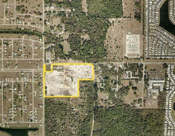
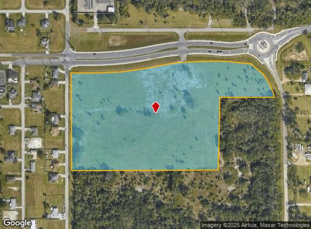
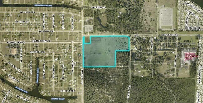
2313 Ne Access Undetermined Ter
Cape Coral-Fort Myers, FL
North Cape Coral
33-43-24-C1-00001.0020
N 958.53 FT OF NW 1/4 W OF CORBETT RD S OF LITTLETON RD LESS PARLS1.0010+1.002A LESS INST 2018000291747 LESS INSTRUMENT 2025000081697
Industrialacreage
Lee
X
Florida
12071C0258G
2
2024
18.13 AC
2025
Cape Coral
010203
Southwest Florida
DEMOGRAPHICS near 2313 Ne Access Undetermined Ter
1 Mile
3 Mile
5 Mile
2024 Total Population
4,305
54,283
125,044
2029 Population
5,093
64,539
148,872
Pop Growth 2024-2029
+ 18.30%
+ 18.89%
+ 19.06%
Average Age
54
45
46
2024 Total Households
2,120
22,501
52,365
HH Growth 2024-2029
+ 18.07%
+ 18.33%
+ 18.61%
Median Household Inc
$53,533
$57,561
$57,185
Avg Household Size
2.00
2.30
2.30
2024 Avg HH Vehicles
2.00
2.00
2.00
Median Home Value
$140,873
$189,132
$211,058
Median Year Built
1992
1993
1992
Nearby Places
Map Layers
Map Styles
 Street
 Aerial
- Restaurants
- Banks
- Shops
- Fitness
- Groceries
PUBLIC TRANSPORTATION
AIRPORT
Southwest Florida International
DRIVE
WALK
Distance
Southwest Florida International
33 min
19.7 mi
Punta Gorda
DRIVE
WALK
Distance
Punta Gorda
29 min
20.1 mi
Freight Ports
Port Manatee
DRIVE
WALK
Distance
Port Manatee
109 min
91.8 mi
SALE & LEASE HISTORY
LISTING DATE
SALE/LEASE

Sep 24, 2016
For Sale
Nearby Properties
Address
Land Use
TOTAL SIZE
Lot Size
Zoning
Address
Land Use
TOTAL SIZE
Lot Size
Zoning
214,515 SF
30.60 AC
I-1
Address
Land Use
TOTAL SIZE
Lot Size
Zoning
485,271 SF
20.05 AC
CORR
Address
Land Use
TOTAL SIZE
Lot Size
Zoning
347,871 SF
29.40 AC
RML
Address
Land Use
TOTAL SIZE
Lot Size
Zoning
13.60 AC
CC
Address
Land Use
TOTAL SIZE
Lot Size
Zoning
262,258 SF
52.71 AC
INS
Address
Land Use
TOTAL SIZE
Lot Size
Zoning
333,938 SF
35.80 AC
C-1
Address
Land Use
TOTAL SIZE
Lot Size
Zoning
61,844 SF
7.31 AC
CC
Address
Land Use
TOTAL SIZE
Lot Size
Zoning
138,476 SF
4.11 AC
CORR
Address
Land Use
TOTAL SIZE
Lot Size
Zoning
451,348 SF
21.43 AC
CPD
Address
Land Use
TOTAL SIZE
Lot Size
Zoning
209,881 SF
63.03 AC
AG-2
Address
Land Use
TOTAL SIZE
Lot Size
Zoning
124,182 SF
13.30 AC
CORR
Address
Land Use
TOTAL SIZE
Lot Size
Zoning
124,101 SF
11.60 AC
C-1
Address
Land Use
TOTAL SIZE
Lot Size
Zoning
76,042 SF
7.50 AC
CORR
Address
Land Use
TOTAL SIZE
Lot Size
Zoning
82,478 SF
15.46 AC
CORR
Address
Land Use
TOTAL SIZE
Lot Size
Zoning
212,616 SF
6.61 AC
CORR/CPO
Address
Land Use
TOTAL SIZE
Lot Size
Zoning
128,355 SF
19.24 AC
C-1
Address
Land Use
TOTAL SIZE
Lot Size
Zoning
112,356 SF
18.99 AC
AG-2
Address
Land Use
TOTAL SIZE
Lot Size
Zoning
109,404 SF
14.22 AC
AG-2
Address
Land Use
TOTAL SIZE
Lot Size
Zoning
51,478 SF
68.97 AC
C-2
Address
Land Use
TOTAL SIZE
Lot Size
Zoning
107,321 SF
7.80 AC
C-1A
Address
Land Use
TOTAL SIZE
Lot Size
Zoning
74,678 SF
8.97 AC
CPD
Address
Land Use
TOTAL SIZE
Lot Size
Zoning
92,632 SF
32 AC
R1BD
Address
Land Use
TOTAL SIZE
Lot Size
Zoning
141,571 SF
4.57 AC
C-1A
Address
Land Use
TOTAL SIZE
Lot Size
Zoning
222,159 SF
25.12 AC
CP-D
Address
Land Use
TOTAL SIZE
Lot Size
Zoning
81,160 SF
9.40 AC
CPD
Address
Land Use
TOTAL SIZE
Lot Size
Zoning
39,204 SF
5.89 AC
CORR
Address
Land Use
TOTAL SIZE
Lot Size
Zoning
197,353 SF
14 AC
VILL
Address
Land Use
TOTAL SIZE
Lot Size
Zoning
58,339 SF
3.55 AC
VILL
Address
Land Use
TOTAL SIZE
Lot Size
Zoning
81,845 SF
5.53 AC
CORR
Address
Land Use
TOTAL SIZE
Lot Size
Zoning
79,253 SF
11.47 AC
C-3
The World's #1 Commercial Real Estate Marketplace
Connect with us
© 2025 CoStar Group
The information above has been obtained from sources believed reliable. While we do not doubt its accuracy we have not verified it and make no guarantee, warranty or representation about it. It is your responsibility to independently confirm its accuracy and completeness. Any projections, opinions, assumptions, or estimates used are for example only and do not represent the current or future performance of the property. The value of this transaction to you depends on tax and other factors which should be evaluated by your tax, financial, and legal advisors. You and your advisors should conduct a careful, independent investigation of the property to determine to your satisfaction the suitability of the property for your needs.