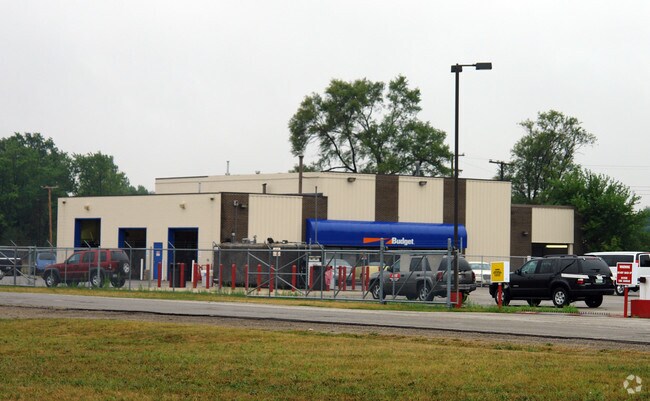
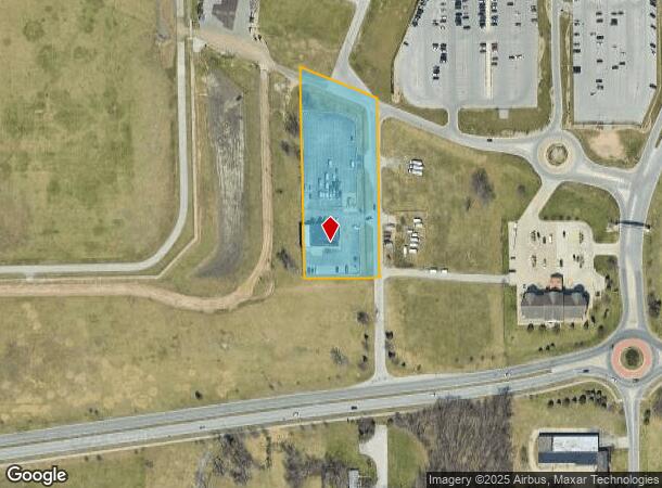
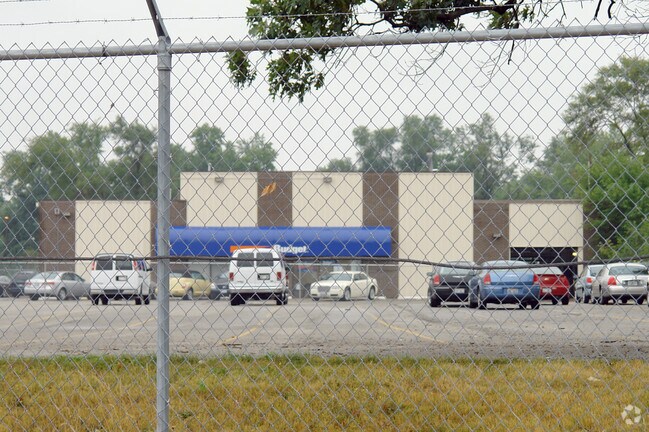
Property Record
23134 L W Way W, South Bend, IN 46628
NEARBY LISTINGS FOR SALE OR LEASE
Property Detail
23134 L W Way W
71-03-32-480-003.000-008
IRREG TR 222.41 S SIDE LINC. HWY BEG CEN LINE OF HWY & MOSS RD & N1/2 VAC KELLER STREET S & ADJ 09/10 VAC ORD 96-08
Storebuilding
St Joseph
X
Indiana
18141C0179D
3.50 AC
2023
Outlying St Joseph County
2024
South Bend/Mishawaka
011001
South Bend-Mishawaka, IN-MI
6,000 SF
DEMOGRAPHICS near 23134 L W Way W
1 Mile
3 Mile
5 Mile
2024 Total Population
3,015
44,572
102,466
2029 Population
2,981
44,758
103,135
Pop Growth 2024-2029
(1.13%)
+ 0.42%
+ 0.65%
Average Age
39
36
36
2024 Total Households
1,185
16,385
37,268
HH Growth 2024-2029
(1.10%)
+ 0.24%
+ 0.72%
Median Household Inc
$42,877
$41,734
$49,509
Avg Household Size
2.40
2.50
2.40
2024 Avg HH Vehicles
2.00
2.00
2.00
Median Home Value
$87,947
$86,497
$133,264
Median Year Built
1955
1955
1958
Nearby Places
Map Layers
Map Styles
 Street
 Aerial
- Restaurants
- Banks
- Shops
- Fitness
- Groceries
PUBLIC TRANSPORTATION
COMMUTER RAIL
South Bend Airport Station (South Shore Line - Northern Indiana Commuter Transportation District (South Shore Line))
DRIVE
WALK
Distance
South Bend Airport Station (South Shore Line - Northern Indiana Commuter Transportation District (South Shore Line))
3 min
12 min
0.6 mi
South Bend Amtrak Station (Capitol Limited - Amtrak, Lake Shore Limited - Amtrak)
DRIVE
WALK
Distance
South Bend Amtrak Station (Capitol Limited - Amtrak, Lake Shore Limited - Amtrak)
6 min
2.9 mi
AIRPORT
South Bend International
DRIVE
WALK
Distance
South Bend International
11 min
2.4 mi
Freight Ports
Port Milwaukee
DRIVE
WALK
Distance
Port Milwaukee
213 min
176.8 mi
Nearby Properties
Address
Land Use
TOTAL SIZE
Lot Size
Zoning
Address
Land Use
TOTAL SIZE
Lot Size
Zoning
538,338 SF
0.01 AC
Address
Land Use
TOTAL SIZE
Lot Size
Zoning
25,756 SF
337.40 AC
Address
Land Use
TOTAL SIZE
Lot Size
Zoning
356,520 SF
28.07 AC
Address
Land Use
TOTAL SIZE
Lot Size
Zoning
252,327 SF
131 SF
Address
Land Use
TOTAL SIZE
Lot Size
Zoning
747,842 SF
30.05 AC
Address
Land Use
TOTAL SIZE
Lot Size
Zoning
232,200 SF
87 SF
Address
Land Use
TOTAL SIZE
Lot Size
Zoning
633,966 SF
87 SF
Address
Land Use
TOTAL SIZE
Lot Size
Zoning
213,400 SF
44 SF
Address
Land Use
TOTAL SIZE
Lot Size
Zoning
225,000 SF
19.59 AC
Address
Land Use
TOTAL SIZE
Lot Size
Zoning
111,803 SF
7.45 AC
Address
Land Use
TOTAL SIZE
Lot Size
Zoning
165,725 SF
0.01 AC
Address
Land Use
TOTAL SIZE
Lot Size
Zoning
214,657 SF
131 SF
Address
Land Use
TOTAL SIZE
Lot Size
Zoning
79,451 SF
87 SF
Address
Land Use
TOTAL SIZE
Lot Size
Zoning
4,428 SF
0.02 AC
Address
Land Use
TOTAL SIZE
Lot Size
Zoning
203,750 SF
22.36 AC
Address
Land Use
TOTAL SIZE
Lot Size
Zoning
255,684 SF
23.71 AC
Address
Land Use
TOTAL SIZE
Lot Size
Zoning
397,100 SF
45.61 AC
Address
Land Use
TOTAL SIZE
Lot Size
Zoning
92,456 SF
44 SF
Address
Land Use
TOTAL SIZE
Lot Size
Zoning
84,398 SF
44 SF
Address
Land Use
TOTAL SIZE
Lot Size
Zoning
143,917 SF
87 SF
Address
Land Use
TOTAL SIZE
Lot Size
Zoning
85,928 SF
7.83 AC
Address
Land Use
TOTAL SIZE
Lot Size
Zoning
266,881 SF
26.20 AC
Address
Land Use
TOTAL SIZE
Lot Size
Zoning
499,104 SF
87 SF
Address
Land Use
TOTAL SIZE
Lot Size
Zoning
17,176 SF
73 AC
Address
Land Use
TOTAL SIZE
Lot Size
Zoning
194,712 SF
14.81 AC
Address
Land Use
TOTAL SIZE
Lot Size
Zoning
164,508 SF
61.83 AC
Address
Land Use
TOTAL SIZE
Lot Size
Zoning
797,259 SF
45.69 AC
Address
Land Use
TOTAL SIZE
Lot Size
Zoning
58,827 SF
131 SF
Address
Land Use
TOTAL SIZE
Lot Size
Zoning
143,805 SF
8.44 AC
Address
Land Use
TOTAL SIZE
Lot Size
Zoning
128,825 SF
12.05 AC
The World's #1 Commercial Real Estate Marketplace
Connect with us
© 2025 CoStar Group
The information above has been obtained from sources believed reliable. While we do not doubt its accuracy we have not verified it and make no guarantee, warranty or representation about it. It is your responsibility to independently confirm its accuracy and completeness. Any projections, opinions, assumptions, or estimates used are for example only and do not represent the current or future performance of the property. The value of this transaction to you depends on tax and other factors which should be evaluated by your tax, financial, and legal advisors. You and your advisors should conduct a careful, independent investigation of the property to determine to your satisfaction the suitability of the property for your needs.