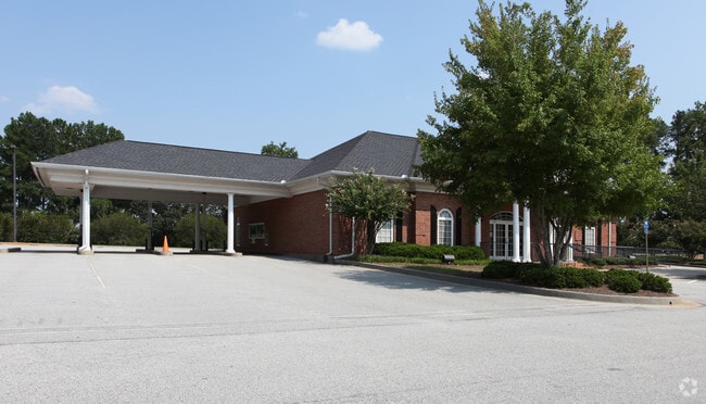
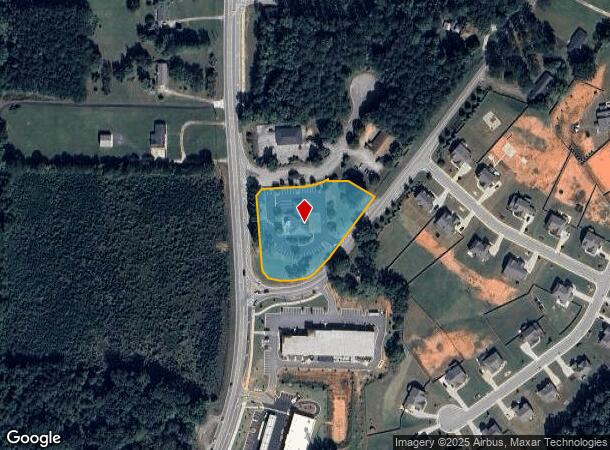
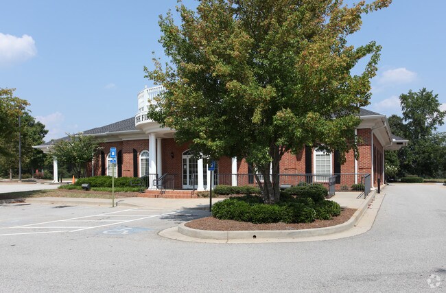
Property Record
2314 Highway 155 N, Mcdonough, GA 30252
NEARBY LISTINGS FOR SALE OR LEASE
Property Detail
2314 Highway 155 N
0103-02-033-001
Hamilton State Bank
Financialbuilding
LAND LOT: 7 LAND DISTRICT: 7
X
Henry
13151C0095D
Georgia
2025
2.47 AC
2025
McDonough/Butts
070209
Atlanta
5,256 SF
Atlanta-Sandy Springs-Roswell, GA
DEMOGRAPHICS near 2314 Highway 155 N
1 Mile
3 Mile
5 Mile
2024 Total Population
1,443
19,521
67,076
2029 Population
1,581
21,260
73,025
Pop Growth 2024-2029
+ 9.56%
+ 8.91%
+ 8.87%
Average Age
38
40
39
2024 Total Households
464
6,541
23,097
HH Growth 2024-2029
+ 9.70%
+ 8.96%
+ 8.91%
Median Household Inc
$90,798
$94,362
$86,065
Avg Household Size
3.10
2.90
2.90
2024 Avg HH Vehicles
2.00
2.00
2.00
Median Home Value
$257,309
$281,971
$273,184
Median Year Built
1997
1998
1999
Nearby Places
Map Layers
Map Styles
 Street
 Aerial
- Restaurants
- Banks
- Shops
- Fitness
- Groceries
PUBLIC TRANSPORTATION
AIRPORT
Hartsfield - Jackson Atlanta International
DRIVE
WALK
Distance
Hartsfield - Jackson Atlanta International
34 min
23.1 mi
Nearby Properties
Address
Land Use
TOTAL SIZE
Lot Size
Zoning
Address
Land Use
TOTAL SIZE
Lot Size
Zoning
13,072 SF
32.50 AC
RM
Address
Land Use
TOTAL SIZE
Lot Size
Zoning
540,464 SF
86.60 AC
RA
Address
Land Use
TOTAL SIZE
Lot Size
Zoning
367,812 SF
14.88 AC
C2
Address
Land Use
TOTAL SIZE
Lot Size
Zoning
68,500 SF
140.42 AC
R2
Address
Land Use
TOTAL SIZE
Lot Size
Zoning
69,524 SF
11.99 AC
RA
Address
Land Use
TOTAL SIZE
Lot Size
Zoning
25,020 SF
169.25 AC
RA
Address
Land Use
TOTAL SIZE
Lot Size
Zoning
81,800 SF
31.31 AC
RA
Address
Land Use
TOTAL SIZE
Lot Size
Zoning
109,203 SF
19.50 AC
RA
Address
Land Use
TOTAL SIZE
Lot Size
Zoning
83,281 SF
15.46 AC
M1
Address
Land Use
TOTAL SIZE
Lot Size
Zoning
51,578 SF
5.75 AC
C3
Address
Land Use
TOTAL SIZE
Lot Size
Zoning
1,818 SF
163.82 AC
RA
Address
Land Use
TOTAL SIZE
Lot Size
Zoning
83,262 SF
30.71 AC
RA
Address
Land Use
TOTAL SIZE
Lot Size
Zoning
82,676 SF
33.82 AC
RA
Address
Land Use
TOTAL SIZE
Lot Size
Zoning
28,764 SF
20.11 AC
RA
Address
Land Use
TOTAL SIZE
Lot Size
Zoning
23,288 SF
20 AC
OI
Address
Land Use
TOTAL SIZE
Lot Size
Zoning
17,541 SF
1.50 AC
C2
Address
Land Use
TOTAL SIZE
Lot Size
Zoning
127,800 SF
6.70 AC
M1
Address
Land Use
TOTAL SIZE
Lot Size
Zoning
17,955 SF
2.23 AC
Address
Land Use
TOTAL SIZE
Lot Size
Zoning
22,750 SF
4.30 AC
C3
Address
Land Use
TOTAL SIZE
Lot Size
Zoning
22,422 SF
3.03 AC
C1
Address
Land Use
TOTAL SIZE
Lot Size
Zoning
9,750 SF
3.17 AC
C1
Address
Land Use
TOTAL SIZE
Lot Size
Zoning
77,200 SF
3.60 AC
M1
Address
Land Use
TOTAL SIZE
Lot Size
Zoning
9,954 SF
1.66 AC
C3
Address
Land Use
TOTAL SIZE
Lot Size
Zoning
8,380 SF
1.17 AC
C2
Address
Land Use
TOTAL SIZE
Lot Size
Zoning
72,306 SF
2.58 AC
C1
Address
Land Use
TOTAL SIZE
Lot Size
Zoning
20,740 SF
2.47 AC
C
Address
Land Use
TOTAL SIZE
Lot Size
Zoning
3,556 SF
1.41 AC
Address
Land Use
TOTAL SIZE
Lot Size
Zoning
11,307 SF
2.26 AC
C2
Address
Land Use
TOTAL SIZE
Lot Size
Zoning
20,312 SF
2 AC
M1
Address
Land Use
TOTAL SIZE
Lot Size
Zoning
80,704 SF
1.99 AC
M1
The World's #1 Commercial Real Estate Marketplace
Connect with us
© 2026 CoStar Group
The information above has been obtained from sources believed reliable. While we do not doubt its accuracy we have not verified it and make no guarantee, warranty or representation about it. It is your responsibility to independently confirm its accuracy and completeness. Any projections, opinions, assumptions, or estimates used are for example only and do not represent the current or future performance of the property. The value of this transaction to you depends on tax and other factors which should be evaluated by your tax, financial, and legal advisors. You and your advisors should conduct a careful, independent investigation of the property to determine to your satisfaction the suitability of the property for your needs.