Property Record
2315 8Th St Sw, Decatur, AL 35601
NEARBY LISTINGS FOR SALE OR LEASE
Property Detail
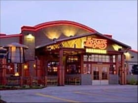
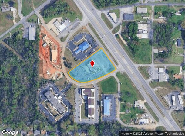
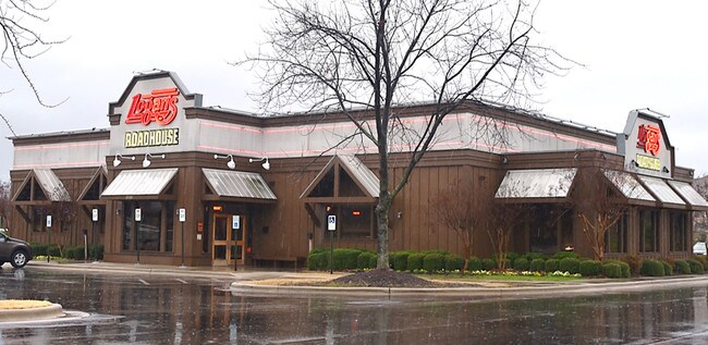
2315 8Th St Sw
Decatur, AL
Courtyard Plaza (2000/4)
02-07-26-2-000-039.003
LOT 4, COURTYARD PLAZA, MB 2000, PG. 4, SEC 26, T5S, R5W
Restaurantbuilding
Morgan
X
Alabama
01103C0059F
4
2025
2.44 AC
2024
Alabama North Area
000700
Other Market Areas
8,040 SF
DEMOGRAPHICS near 2315 8Th St Sw
1 Mile
3 Mile
5 Mile
2024 Total Population
6,835
37,145
60,125
2029 Population
6,848
37,347
60,467
Pop Growth 2024-2029
+ 0.19%
+ 0.54%
+ 0.57%
Average Age
39
39
40
2024 Total Households
2,941
14,809
24,362
HH Growth 2024-2029
+ 0.24%
+ 0.53%
+ 0.56%
Median Household Inc
$56,237
$48,565
$49,202
Avg Household Size
2.30
2.40
2.30
2024 Avg HH Vehicles
2.00
2.00
2.00
Median Home Value
$158,659
$144,750
$156,809
Median Year Built
1987
1979
1977
Nearby Places
Map Layers
Map Styles
 Street
 Aerial
- Restaurants
- Banks
- Shops
- Fitness
- Groceries
PUBLIC TRANSPORTATION
AIRPORT
Huntsville International-Carl T Jones Field
DRIVE
WALK
Distance
Huntsville International-Carl T Jones Field
30 min
19.1 mi
SALE & LEASE HISTORY
LISTING DATE
SALE/LEASE

Mar 21, 2019
For Sale
Mar 06, 2017
For Sale
Mar 06, 2017
For Sale
Nearby Properties
Address
Land Use
TOTAL SIZE
Lot Size
Zoning
Address
Land Use
TOTAL SIZE
Lot Size
Zoning
176,476 SF
Address
Land Use
TOTAL SIZE
Lot Size
Zoning
121,551 SF
Address
Land Use
TOTAL SIZE
Lot Size
Zoning
81,916 SF
45 AC
Address
Land Use
TOTAL SIZE
Lot Size
Zoning
124,209 SF
26 AC
Address
Land Use
TOTAL SIZE
Lot Size
Zoning
90,249 SF
8 AC
Address
Land Use
TOTAL SIZE
Lot Size
Zoning
36,304 SF
97 AC
Address
Land Use
TOTAL SIZE
Lot Size
Zoning
103,569 SF
6.69 AC
Address
Land Use
TOTAL SIZE
Lot Size
Zoning
35,727 SF
10 AC
Address
Land Use
TOTAL SIZE
Lot Size
Zoning
9,332 SF
Address
Land Use
TOTAL SIZE
Lot Size
Zoning
33,520 SF
Address
Land Use
TOTAL SIZE
Lot Size
Zoning
48,364 SF
1.80 AC
Address
Land Use
TOTAL SIZE
Lot Size
Zoning
40,212 SF
1.21 AC
Address
Land Use
TOTAL SIZE
Lot Size
Zoning
54,544 SF
6.53 AC
Address
Land Use
TOTAL SIZE
Lot Size
Zoning
51,958 SF
14 AC
Address
Land Use
TOTAL SIZE
Lot Size
Zoning
261,328 SF
67 AC
Address
Land Use
TOTAL SIZE
Lot Size
Zoning
106,165 SF
0.80 AC
Address
Land Use
TOTAL SIZE
Lot Size
Zoning
377,685 SF
17 AC
Address
Land Use
TOTAL SIZE
Lot Size
Zoning
81,682 SF
13 AC
Address
Land Use
TOTAL SIZE
Lot Size
Zoning
205,279 SF
25.45 AC
Address
Land Use
TOTAL SIZE
Lot Size
Zoning
135,440 SF
6.76 AC
Address
Land Use
TOTAL SIZE
Lot Size
Zoning
10,884 SF
0.90 AC
Address
Land Use
TOTAL SIZE
Lot Size
Zoning
2,546 SF
9.30 AC
Address
Land Use
TOTAL SIZE
Lot Size
Zoning
40,008 SF
19.90 AC
Address
Land Use
TOTAL SIZE
Lot Size
Zoning
4,181 SF
6.70 AC
Address
Land Use
TOTAL SIZE
Lot Size
Zoning
49,384 SF
1.07 AC
Address
Land Use
TOTAL SIZE
Lot Size
Zoning
81,042 SF
2.39 AC
Address
Land Use
TOTAL SIZE
Lot Size
Zoning
146,160 SF
41.50 AC
Address
Land Use
TOTAL SIZE
Lot Size
Zoning
42,197 SF
3.75 AC
Address
Land Use
TOTAL SIZE
Lot Size
Zoning
31,473 SF
2.90 AC
Address
Land Use
TOTAL SIZE
Lot Size
Zoning
19,198 SF
15 AC
The World's #1 Commercial Real Estate Marketplace
Connect with us
© 2025 CoStar Group
The information above has been obtained from sources believed reliable. While we do not doubt its accuracy we have not verified it and make no guarantee, warranty or representation about it. It is your responsibility to independently confirm its accuracy and completeness. Any projections, opinions, assumptions, or estimates used are for example only and do not represent the current or future performance of the property. The value of this transaction to you depends on tax and other factors which should be evaluated by your tax, financial, and legal advisors. You and your advisors should conduct a careful, independent investigation of the property to determine to your satisfaction the suitability of the property for your needs.