Property Record
2315 Bel Air Rd, Fallston, MD 21047
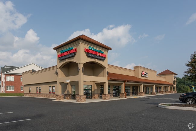


Property Detail
2315 Bel Air Rd
03-061337
LOT 1 13.77 AC 2315 BEL AIR ROAD FALLSTON MALL PT 90/44
Restaurantdrivein
HARFORD
B3
Maryland
AO River or stream flood hazard areas, and areas with a 1% or greater chance of shallow flooding each year. These areas have a 26% chance of flooding over the life of a 30-year mortgage.
1
2025
13.77 AC
2025
Outlying Harford County
303400
Baltimore
2,520 SF
Baltimore-Columbia-Towson, MD
NEARBY LISTINGS FOR SALE OR LEASE
DEMOGRAPHICS near 2315 Bel Air Rd
1 mile
3 mile
5 mile
2025 Total Population
2,914
18,828
91,558
2030 Population
2,942
18,971
91,801
Pop Growth 2025-2030
+ 0.96%
+ 0.76%
+ 0.27%
Average Age
45
44
42
2025 Total Households
1,057
7,112
34,843
HH Growth 2025-2030
+ 1.04%
+ 0.82%
+ 0.28%
Median Household Inc
$139,341
$128,157
$115,759
Avg Household Size
2.70
2.60
2.60
2025 Avg HH Vehicles
2.00
2.00
2.00
Median Home Value
$525,398
$478,023
$424,874
Median Year Built
1989
1979
1985
Nearby Places
Map Layers
Map Styles
 Street
 Aerial
Layers
 Traffic
 Biking
Places
Listings with unknown addresses are not visible on the map
- Restaurants
- Banks
- Shops
- Fitness
- Groceries
PUBLIC TRANSPORTATION
COMMUTER RAIL
Edgewood Marc Nb (PENN - WASHINGTON - Maryland Transit Administration)
Drive
Walk
Distance
Edgewood Marc Nb (PENN - WASHINGTON - Maryland Transit Administration)
16 min
9.0 mi
AIRPORT
Baltimore/Washington International Thurgood Marshall
Drive
Walk
Distance
Baltimore/Washington International Thurgood Marshall
49 min
33.9 mi
Freight Ports
Port of Baltimore
Drive
Walk
Distance
Port of Baltimore
36 min
25.2 mi
SALE & LEASE HISTORY
LISTING DATE
SALE/LEASE

May 10, 2017
For Lease
Nearby Properties
Address
Land Use
TOTAL SIZE
Lot Size
Zoning
Address
Land Use
TOTAL SIZE
Lot Size
Zoning
42,087 SF
17.21 AC
B3
Address
Land Use
TOTAL SIZE
Lot Size
Zoning
8,503 SF
20.86 AC
B3
Address
Land Use
TOTAL SIZE
Lot Size
Zoning
233,500 SF
96.38 AC
AG
Address
Land Use
TOTAL SIZE
Lot Size
Zoning
223,629 SF
29.38 AC
M1
Address
Land Use
TOTAL SIZE
Lot Size
Zoning
52,224 SF
10.38 AC
B1
Address
Land Use
TOTAL SIZE
Lot Size
Zoning
15,010 SF
19.12 AC
B3
Address
Land Use
TOTAL SIZE
Lot Size
Zoning
152,130 SF
21.10 AC
B2 B3
Address
Land Use
TOTAL SIZE
Lot Size
Zoning
1,496 SF
11.55 AC
M1
Address
Land Use
TOTAL SIZE
Lot Size
Zoning
46,174 SF
5 AC
R2
Address
Land Use
TOTAL SIZE
Lot Size
Zoning
62,219 SF
4.43 AC
M1
Address
Land Use
TOTAL SIZE
Lot Size
Zoning
32,960 SF
9.17 AC
B3
Address
Land Use
TOTAL SIZE
Lot Size
Zoning
110,163 SF
19.45 AC
B3
Address
Land Use
TOTAL SIZE
Lot Size
Zoning
14,412 SF
9.29 AC
B3
Address
Land Use
TOTAL SIZE
Lot Size
Zoning
16,129 SF
58.25 AC
AG
Address
Land Use
TOTAL SIZE
Lot Size
Zoning
9,786 SF
7.68 AC
M1
Address
Land Use
TOTAL SIZE
Lot Size
Zoning
6,889 SF
7.83 AC
B3
Address
Land Use
TOTAL SIZE
Lot Size
Zoning
126,215 SF
1.70 AC
B3
Address
Land Use
TOTAL SIZE
Lot Size
Zoning
10,384 SF
4.44 AC
B3
Address
Land Use
TOTAL SIZE
Lot Size
Zoning
26,104 SF
24.49 AC
CI
Address
Land Use
TOTAL SIZE
Lot Size
Zoning
115,818 SF
5.60 AC
AG
Address
Land Use
TOTAL SIZE
Lot Size
Zoning
53,500 SF
13 AC
RC5
Address
Land Use
TOTAL SIZE
Lot Size
Zoning
10,800 SF
3.25 AC
B3
Address
Land Use
TOTAL SIZE
Lot Size
Zoning
10,266 SF
3.66 AC
B3
Address
Land Use
TOTAL SIZE
Lot Size
Zoning
13,206 SF
1.81 AC
B3
Address
Land Use
TOTAL SIZE
Lot Size
Zoning
8,428 SF
245.23 AC
AG
Address
Land Use
TOTAL SIZE
Lot Size
Zoning
23,371 SF
7.52 AC
B3
Address
Land Use
TOTAL SIZE
Lot Size
Zoning
1,030 SF
5.36 AC
B3
Address
Land Use
TOTAL SIZE
Lot Size
Zoning
21,008 SF
1.22 AC
M1
Address
Land Use
TOTAL SIZE
Lot Size
Zoning
22,280 SF
6.03 AC
M1
The World's #1 Commercial Real Estate Marketplace
Connect with us
© 2026 CoStar Group
The information above has been obtained from sources believed reliable. While we do not doubt its accuracy we have not verified it and make no guarantee, warranty or representation about it. It is your responsibility to independently confirm its accuracy and completeness. Any projections, opinions, assumptions, or estimates used are for example only and do not represent the current or future performance of the property. The value of this transaction to you depends on tax and other factors which should be evaluated by your tax, financial, and legal advisors. You and your advisors should conduct a careful, independent investigation of the property to determine to your satisfaction the suitability of the property for your needs.