Property Record
2315 Sparger Rd, Durham, NC 27705


Property Detail
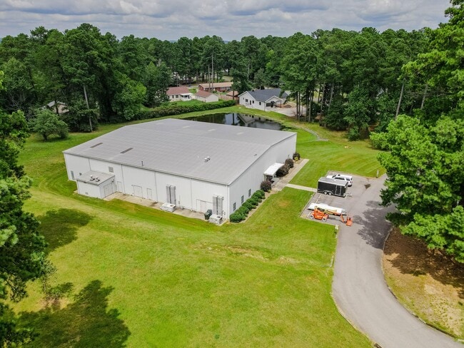
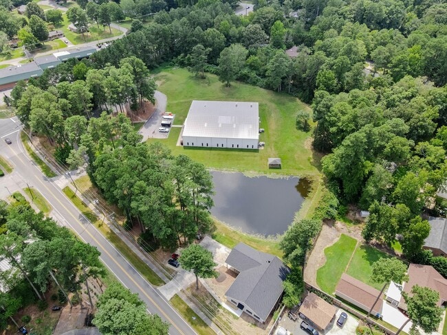
2315 Sparger Rd
175644
PROP-SPINE REHABILITATION & REDUCATION CTR OF N C PL:000128-000067
Publichealthcarefacility
Durham
CG(D)
North Carolina
B and X Area of moderate flood hazard, usually the area between the limits of the 100-year and 500-year floods.
5.08 AC
2025
South Durham
2025
Raleigh/Durham
001713
Durham-Chapel Hill, NC
2,604 SF
NEARBY LISTINGS FOR SALE OR LEASE
DEMOGRAPHICS near 2315 Sparger Rd
1 mile
3 mile
5 mile
2025 Total Population
3,481
30,247
101,214
2030 Population
3,649
31,776
106,693
Pop Growth 2025-2030
+ 4.83%
+ 5.06%
+ 5.41%
Average Age
44
40
39
2025 Total Households
1,465
14,144
43,742
HH Growth 2025-2030
+ 4.98%
+ 5.44%
+ 5.90%
Median Household Inc
$123,881
$74,017
$74,718
Avg Household Size
2.30
2.10
2.20
2025 Avg HH Vehicles
2.00
2.00
2.00
Median Home Value
$412,115
$458,596
$462,008
Median Year Built
1986
1990
1986
Nearby Places
Map Layers
Map Styles
 Street
 Aerial
Layers
 Traffic
 Biking
Places
Listings with unknown addresses are not visible on the map
- Restaurants
- Banks
- Shops
- Fitness
- Groceries
PUBLIC TRANSPORTATION
COMMUTER RAIL
Drive
Walk
Distance
12 min
6.2 mi
AIRPORT
Raleigh-Durham International
Drive
Walk
Distance
Raleigh-Durham International
31 min
20.3 mi
SALE & LEASE HISTORY
LISTING DATE
SALE/LEASE

Oct 21, 2025
For Lease
Mar 20, 2025
For Lease
Aug 25, 2021
For Lease
Nearby Properties
Address
Land Use
TOTAL SIZE
Lot Size
Zoning
Address
Land Use
TOTAL SIZE
Lot Size
Zoning
758,666 SF
99.64 AC
PDR 2.000
Address
Land Use
TOTAL SIZE
Lot Size
Zoning
416,469 SF
3.85 AC
MU(D)
Address
Land Use
TOTAL SIZE
Lot Size
Zoning
132,520 SF
15.94 AC
RU-M(D)
Address
Land Use
TOTAL SIZE
Lot Size
Zoning
12,236 SF
43.44 AC
RU-M
Address
Land Use
TOTAL SIZE
Lot Size
Zoning
441,868 SF
6.11 AC
MU(D)
Address
Land Use
TOTAL SIZE
Lot Size
Zoning
903.08 AC
RR,RS-20,U
Address
Land Use
TOTAL SIZE
Lot Size
Zoning
296,580 SF
2.53 AC
MU(D)
Address
Land Use
TOTAL SIZE
Lot Size
Zoning
9,126 SF
20.02 AC
RU-M
Address
Land Use
TOTAL SIZE
Lot Size
Zoning
9,318 SF
19.27 AC
RS-M
Address
Land Use
TOTAL SIZE
Lot Size
Zoning
1.19 AC
MU(D)
Address
Land Use
TOTAL SIZE
Lot Size
Zoning
153,300 SF
0.99 AC
MU(D)
Address
Land Use
TOTAL SIZE
Lot Size
Zoning
13,432 SF
21.46 AC
RU-M
Address
Land Use
TOTAL SIZE
Lot Size
Zoning
12,468 SF
13.33 AC
RU-M(D)
Address
Land Use
TOTAL SIZE
Lot Size
Zoning
20,508 SF
15.82 AC
RS-M
Address
Land Use
TOTAL SIZE
Lot Size
Zoning
36,380 SF
4.02 AC
MU(D)
Address
Land Use
TOTAL SIZE
Lot Size
Zoning
6,822 SF
24.64 AC
PDR 2.000
Address
Land Use
TOTAL SIZE
Lot Size
Zoning
130,550 SF
4.07 AC
I
Address
Land Use
TOTAL SIZE
Lot Size
Zoning
233,478 SF
10.60 AC
OI
Address
Land Use
TOTAL SIZE
Lot Size
Zoning
625 AC
RS-20
Address
Land Use
TOTAL SIZE
Lot Size
Zoning
15,198 SF
12.79 AC
RU-M
Address
Land Use
TOTAL SIZE
Lot Size
Zoning
6,936 SF
11.42 AC
PDR 2.000
Address
Land Use
TOTAL SIZE
Lot Size
Zoning
8,824 SF
15.96 AC
RS-M
Address
Land Use
TOTAL SIZE
Lot Size
Zoning
136,387 SF
11.82 AC
IL
Address
Land Use
TOTAL SIZE
Lot Size
Zoning
141,352 SF
8.40 AC
IL
Address
Land Use
TOTAL SIZE
Lot Size
Zoning
79,947 SF
0.90 AC
MU(D)
Address
Land Use
TOTAL SIZE
Lot Size
Zoning
89,448 SF
1.41 AC
MU(D)
Address
Land Use
TOTAL SIZE
Lot Size
Zoning
126,000 SF
0.98 AC
Address
Land Use
TOTAL SIZE
Lot Size
Zoning
112,560 SF
1.14 AC
MU(D)
Address
Land Use
TOTAL SIZE
Lot Size
Zoning
67,353 SF
5.06 AC
CG(D)
Address
Land Use
TOTAL SIZE
Lot Size
Zoning
2,518 SF
9.32 AC
RS-M
The World's #1 Commercial Real Estate Marketplace
Connect with us
© 2026 CoStar Group
The information above has been obtained from sources believed reliable. While we do not doubt its accuracy we have not verified it and make no guarantee, warranty or representation about it. It is your responsibility to independently confirm its accuracy and completeness. Any projections, opinions, assumptions, or estimates used are for example only and do not represent the current or future performance of the property. The value of this transaction to you depends on tax and other factors which should be evaluated by your tax, financial, and legal advisors. You and your advisors should conduct a careful, independent investigation of the property to determine to your satisfaction the suitability of the property for your needs.