Property Record
23150 N Pima Rd, Scottsdale, AZ 85255


Current Lease Availabilities
NEARBY LISTINGS FOR SALE OR LEASE
Property Detail
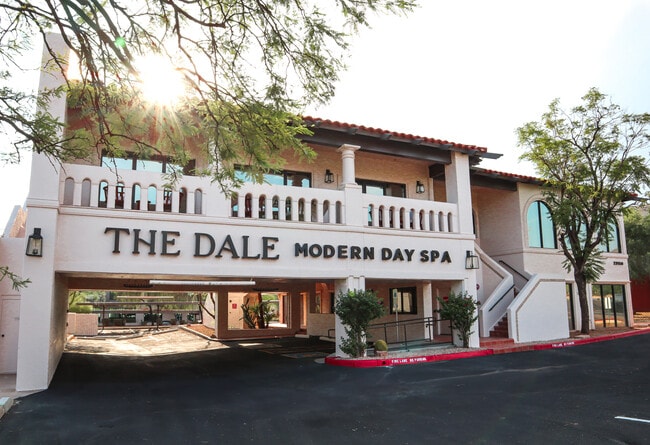
23150 N Pima Rd
Phoenix-Mesa-Scottsdale, AZ
La Vista Bonita
212-01-568M
LA VISTA BONITA MCR 45/46
Officebuilding
Maricopa
X
Arizona
04013C1310M
1
2025
0.45 AC
2025
N Scottsdale/Carefree
216841
Phoenix
7,856 SF
DEMOGRAPHICS near 23150 N Pima Rd
1 Mile
3 Mile
5 Mile
2024 Total Population
3,515
31,997
81,312
2029 Population
3,859
35,415
90,122
Pop Growth 2024-2029
+ 9.79%
+ 10.68%
+ 10.83%
Average Age
50
49
47
2024 Total Households
1,450
14,163
37,052
HH Growth 2024-2029
+ 9.93%
+ 10.97%
+ 11.16%
Median Household Inc
$157,532
$139,553
$123,988
Avg Household Size
2.40
2.20
2.10
2024 Avg HH Vehicles
2.00
2.00
2.00
Median Home Value
$861,217
$860,625
$814,821
Median Year Built
1992
1999
2000
Nearby Places
Map Layers
Map Styles
 Street
 Aerial
- Restaurants
- Banks
- Shops
- Fitness
- Groceries
PUBLIC TRANSPORTATION
AIRPORT
Phoenix Sky Harbor International
DRIVE
WALK
Distance
Phoenix Sky Harbor International
35 min
25.5 mi
Phoenix-Mesa Gateway
DRIVE
WALK
Distance
Phoenix-Mesa Gateway
55 min
40.5 mi
Freight Ports
Port of San Diego
DRIVE
WALK
Distance
Port of San Diego
426 min
380.4 mi
Nearby Properties
Address
Land Use
TOTAL SIZE
Lot Size
Zoning
Address
Land Use
TOTAL SIZE
Lot Size
Zoning
20.98 AC
Address
Land Use
TOTAL SIZE
Lot Size
Zoning
13.01 AC
Address
Land Use
TOTAL SIZE
Lot Size
Zoning
1,479,005 SF
12.55 AC
PC
Address
Land Use
TOTAL SIZE
Lot Size
Zoning
Address
Land Use
TOTAL SIZE
Lot Size
Zoning
Address
Land Use
TOTAL SIZE
Lot Size
Zoning
229,856 SF
7.71 AC
C-T
Address
Land Use
TOTAL SIZE
Lot Size
Zoning
734,840 SF
33.12 AC
M-H
Address
Land Use
TOTAL SIZE
Lot Size
Zoning
90.73 AC
O-S
Address
Land Use
TOTAL SIZE
Lot Size
Zoning
255,313 SF
22.54 AC
PNC
Address
Land Use
TOTAL SIZE
Lot Size
Zoning
385,376 SF
13.65 AC
PAD
Address
Land Use
TOTAL SIZE
Lot Size
Zoning
41.63 AC
I-1
Address
Land Use
TOTAL SIZE
Lot Size
Zoning
731,843 SF
29.85 AC
M-H
Address
Land Use
TOTAL SIZE
Lot Size
Zoning
328,616 SF
10.56 AC
PAD
Address
Land Use
TOTAL SIZE
Lot Size
Zoning
397,568 SF
16.71 AC
PAD
Address
Land Use
TOTAL SIZE
Lot Size
Zoning
191,639 SF
31.94 AC
O-S
Address
Land Use
TOTAL SIZE
Lot Size
Zoning
58.66 AC
R-43AG
Address
Land Use
TOTAL SIZE
Lot Size
Zoning
69.27 AC
I-P
Address
Land Use
TOTAL SIZE
Lot Size
Zoning
161,955 SF
2.65 AC
Address
Land Use
TOTAL SIZE
Lot Size
Zoning
157,340 SF
4.40 AC
PC
Address
Land Use
TOTAL SIZE
Lot Size
Zoning
570.07 AC
R-43
Address
Land Use
TOTAL SIZE
Lot Size
Zoning
286,776 SF
5.86 AC
C-T
Address
Land Use
TOTAL SIZE
Lot Size
Zoning
48.10 AC
Address
Land Use
TOTAL SIZE
Lot Size
Zoning
270,264 SF
5.84 AC
C-C
Address
Land Use
TOTAL SIZE
Lot Size
Zoning
201,308 SF
3.44 AC
PC
Address
Land Use
TOTAL SIZE
Lot Size
Zoning
36.07 AC
I-P
Address
Land Use
TOTAL SIZE
Lot Size
Zoning
66,317 SF
20.82 AC
R-190
Address
Land Use
TOTAL SIZE
Lot Size
Zoning
115,275 SF
12.16 AC
C-C
Address
Land Use
TOTAL SIZE
Lot Size
Zoning
100,378 SF
12.29 AC
C-C
Address
Land Use
TOTAL SIZE
Lot Size
Zoning
80,105 SF
12.35 AC
PAD
Address
Land Use
TOTAL SIZE
Lot Size
Zoning
77,580 SF
9.84 AC
R-7
The World's #1 Commercial Real Estate Marketplace
Connect with us
© 2026 CoStar Group
The information above has been obtained from sources believed reliable. While we do not doubt its accuracy we have not verified it and make no guarantee, warranty or representation about it. It is your responsibility to independently confirm its accuracy and completeness. Any projections, opinions, assumptions, or estimates used are for example only and do not represent the current or future performance of the property. The value of this transaction to you depends on tax and other factors which should be evaluated by your tax, financial, and legal advisors. You and your advisors should conduct a careful, independent investigation of the property to determine to your satisfaction the suitability of the property for your needs.