Property Record
23155 N State Route 89, Paulden, AZ 86334
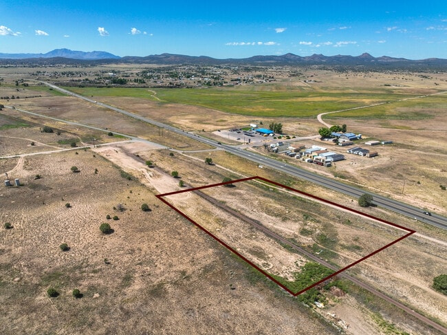

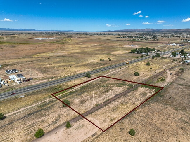
This Property Is For Sale
Property Detail
23155 N State Route 89
Prescott, AZ
A RECT BAL PTN OF THE SW4 OF SEC 3 AND THE SE4 OF SEC 4 THE NE PC L COR LYING APPROX 983 FT NLY OF THE SW COR OF SEC 3 S 3 & 4 17N 2W
306-40-052K
YAVAPAI
Residentialacreage
Arizona
B and X Area of moderate flood hazard, usually the area between the limits of the 100-year and 500-year floods.
2.93 AC
2024
Prescott & Sedona
2026
Other Market Areas
000000
NEARBY LISTINGS FOR SALE OR LEASE
DEMOGRAPHICS near 23155 N State Route 89
1 mile
3 mile
5 mile
2025 Total Population
154
3,675
4,760
2030 Population
157
3,675
4,761
Pop Growth 2025-2030
+ 1.95%
0.00%
+ 0.02%
Average Age
46
44
45
2025 Total Households
61
1,374
1,807
HH Growth 2025-2030
+ 1.64%
+ 0.29%
+ 0.28%
Median Household Inc
$69,374
$64,191
$72,783
Avg Household Size
2.50
2.60
2.50
2025 Avg HH Vehicles
2.00
2.00
2.00
Median Home Value
$364,999
$353,260
$386,440
Median Year Built
1999
1998
1996
Nearby Places
Map Layers
Map Styles
 Street
 Aerial
Transit
 Traffic
 Biking
Places
Listings with unknown addresses are not visible on the map
- Restaurants
- Banks
- Shops
- Fitness
- Groceries
Nearby Properties
Address
Land Use
TOTAL SIZE
Lot Size
Zoning
Address
Land Use
TOTAL SIZE
Lot Size
Zoning
16,800 SF
2.12 AC
Address
Land Use
TOTAL SIZE
Lot Size
Zoning
5,320 SF
1 AC
Address
Land Use
TOTAL SIZE
Lot Size
Zoning
8,000 SF
1.18 AC
Address
Land Use
TOTAL SIZE
Lot Size
Zoning
4,114 SF
41.44 AC
Address
Land Use
TOTAL SIZE
Lot Size
Zoning
3,600 SF
161.95 AC
Address
Land Use
TOTAL SIZE
Lot Size
Zoning
4,155 SF
4.98 AC
Address
Land Use
TOTAL SIZE
Lot Size
Zoning
5,681 SF
13.05 AC
Address
Land Use
TOTAL SIZE
Lot Size
Zoning
10,748 SF
4.66 AC
Address
Land Use
TOTAL SIZE
Lot Size
Zoning
3,775 SF
53.24 AC
Address
Land Use
TOTAL SIZE
Lot Size
Zoning
5,000 SF
2.50 AC
Address
Land Use
TOTAL SIZE
Lot Size
Zoning
2,660 SF
2.27 AC
Address
Land Use
TOTAL SIZE
Lot Size
Zoning
4,188 SF
7.75 AC
Address
Land Use
TOTAL SIZE
Lot Size
Zoning
2,768 SF
20.65 AC
Address
Land Use
TOTAL SIZE
Lot Size
Zoning
2,400 SF
0.64 AC
Address
Land Use
TOTAL SIZE
Lot Size
Zoning
1,650 SF
0.22 AC
Address
Land Use
TOTAL SIZE
Lot Size
Zoning
3,031 SF
11.13 AC
Address
Land Use
TOTAL SIZE
Lot Size
Zoning
119.56 AC
Address
Land Use
TOTAL SIZE
Lot Size
Zoning
3,922 SF
8.51 AC
Address
Land Use
TOTAL SIZE
Lot Size
Zoning
18,498 SF
6.35 AC
Address
Land Use
TOTAL SIZE
Lot Size
Zoning
1,600 SF
10 AC
Address
Land Use
TOTAL SIZE
Lot Size
Zoning
72 SF
40.01 AC
Address
Land Use
TOTAL SIZE
Lot Size
Zoning
3,132 SF
15.81 AC
Address
Land Use
TOTAL SIZE
Lot Size
Zoning
1,298 SF
20.02 AC
Address
Land Use
TOTAL SIZE
Lot Size
Zoning
750 SF
2.15 AC
Address
Land Use
TOTAL SIZE
Lot Size
Zoning
1,306 SF
3 AC
Address
Land Use
TOTAL SIZE
Lot Size
Zoning
61.76 AC
Address
Land Use
TOTAL SIZE
Lot Size
Zoning
Address
Land Use
TOTAL SIZE
Lot Size
Zoning
10.46 AC
Address
Land Use
TOTAL SIZE
Lot Size
Zoning
2,182 SF
The World's #1 Commercial Real Estate Marketplace
Connect with us
© 2026 CoStar Group
The information above has been obtained from sources believed reliable. While we do not doubt its accuracy we have not verified it and make no guarantee, warranty or representation about it. It is your responsibility to independently confirm its accuracy and completeness. Any projections, opinions, assumptions, or estimates used are for example only and do not represent the current or future performance of the property. The value of this transaction to you depends on tax and other factors which should be evaluated by your tax, financial, and legal advisors. You and your advisors should conduct a careful, independent investigation of the property to determine to your satisfaction the suitability of the property for your needs.