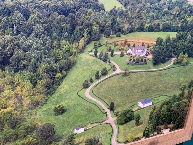
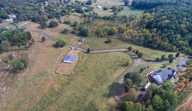
Property Record
2317 Blue Level Rd, Bowling Green, KY 42101

NEARBY LISTINGS FOR SALE OR LEASE
Property Detail
2317 Blue Level Rd
028B-59B
Revision Eastwood Village Professional B
Ruralagriculturalresidence
Warren
X
Kentucky
21141C0225D
Bowling Green Area
2025
Other Market Areas
2025
Bowling Green, KY
011100
DEMOGRAPHICS near 2317 Blue Level Rd
1 mile
3 mile
5 mile
2024 Total Population
318
13,445
50,768
2029 Population
352
14,844
55,492
Pop Growth 2024-2029
+ 10.69%
+ 10.41%
+ 9.31%
Average Age
41
34
33
2024 Total Households
125
4,936
18,067
HH Growth 2024-2029
+ 11.20%
+ 10.82%
+ 9.96%
Median Household Inc
$65,869
$59,895
$48,515
Avg Household Size
2.50
2.60
2.50
2024 Avg HH Vehicles
2.00
2.00
2.00
Median Home Value
$197,058
$174,207
$185,684
Median Year Built
1988
2000
1990
Nearby Places
Map Layers
Map Styles
 Street
 Aerial
Transit
 Traffic
 Biking
Places
Listings with unknown addresses are not visible on the map
- Restaurants
- Banks
- Shops
- Fitness
- Groceries
SALE & LEASE HISTORY
LISTING DATE
SALE/LEASE

Oct 10, 2019
For Sale
Nearby Properties
Address
Land Use
TOTAL SIZE
Lot Size
Zoning
Address
Land Use
TOTAL SIZE
Lot Size
Zoning
462,286 SF
62.54 AC
Address
Land Use
TOTAL SIZE
Lot Size
Zoning
49,434 SF
43.95 AC
Address
Land Use
TOTAL SIZE
Lot Size
Zoning
245,000 SF
80.51 AC
Address
Land Use
TOTAL SIZE
Lot Size
Zoning
3,200 SF
8.61 AC
Address
Land Use
TOTAL SIZE
Lot Size
Zoning
168,353 SF
37.76 AC
Address
Land Use
TOTAL SIZE
Lot Size
Zoning
Address
Land Use
TOTAL SIZE
Lot Size
Zoning
44,800 SF
8.99 AC
Address
Land Use
TOTAL SIZE
Lot Size
Zoning
12.82 AC
Address
Land Use
TOTAL SIZE
Lot Size
Zoning
Address
Land Use
TOTAL SIZE
Lot Size
Zoning
2,833 SF
889 AC
Address
Land Use
TOTAL SIZE
Lot Size
Zoning
8,724 SF
2.09 AC
Address
Land Use
TOTAL SIZE
Lot Size
Zoning
61,144 SF
6 AC
Address
Land Use
TOTAL SIZE
Lot Size
Zoning
146,950 SF
21.46 AC
Address
Land Use
TOTAL SIZE
Lot Size
Zoning
51.68 AC
Address
Land Use
TOTAL SIZE
Lot Size
Zoning
17,280 SF
5.73 AC
Address
Land Use
TOTAL SIZE
Lot Size
Zoning
Address
Land Use
TOTAL SIZE
Lot Size
Zoning
Address
Land Use
TOTAL SIZE
Lot Size
Zoning
5,795 SF
1.97 AC
Address
Land Use
TOTAL SIZE
Lot Size
Zoning
1,980 SF
3.43 AC
Address
Land Use
TOTAL SIZE
Lot Size
Zoning
Address
Land Use
TOTAL SIZE
Lot Size
Zoning
10,136 SF
3.96 AC
Address
Land Use
TOTAL SIZE
Lot Size
Zoning
41.85 AC
Address
Land Use
TOTAL SIZE
Lot Size
Zoning
14.85 AC
Address
Land Use
TOTAL SIZE
Lot Size
Zoning
9,770 SF
3.90 AC
Address
Land Use
TOTAL SIZE
Lot Size
Zoning
Address
Land Use
TOTAL SIZE
Lot Size
Zoning
Address
Land Use
TOTAL SIZE
Lot Size
Zoning
17,324 SF
1.39 AC
Address
Land Use
TOTAL SIZE
Lot Size
Zoning
9,360 SF
2.95 AC
Address
Land Use
TOTAL SIZE
Lot Size
Zoning
Address
Land Use
TOTAL SIZE
Lot Size
Zoning
2,542 SF
3.36 AC
The World's #1 Commercial Real Estate Marketplace
Connect with us
© 2026 CoStar Group
The information above has been obtained from sources believed reliable. While we do not doubt its accuracy we have not verified it and make no guarantee, warranty or representation about it. It is your responsibility to independently confirm its accuracy and completeness. Any projections, opinions, assumptions, or estimates used are for example only and do not represent the current or future performance of the property. The value of this transaction to you depends on tax and other factors which should be evaluated by your tax, financial, and legal advisors. You and your advisors should conduct a careful, independent investigation of the property to determine to your satisfaction the suitability of the property for your needs.