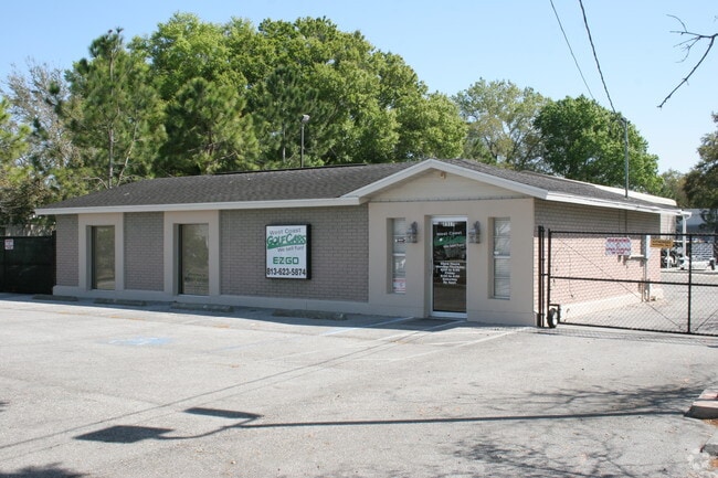
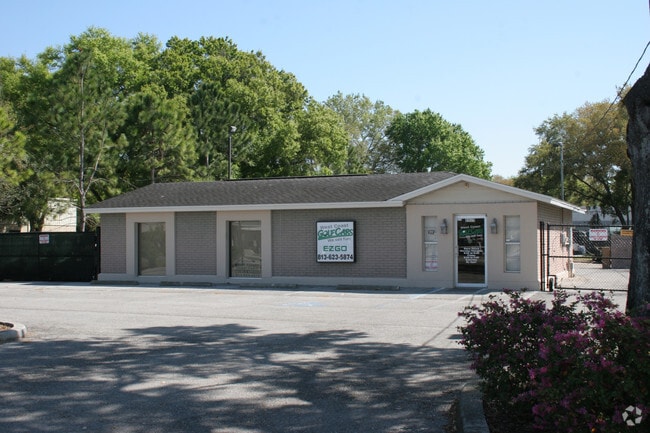
Property Record
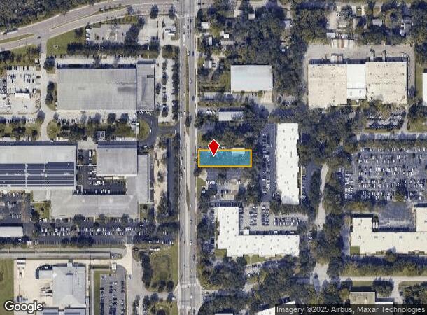
2317 N Falkenburg Rd, Tampa, FL 33619

NEARBY LISTINGS FOR SALE OR LEASE
Property Detail
2317 N Falkenburg Rd
Tampa-St. Petersburg-Clearwater, FL
Unplatted
U-17-29-20-ZZZ-000002-51010.0
S 80 FT OF N 786 FT OF E 257 FT OF W 282 FT OF NW 1/4 OF NW 1/4
Vehiclerentalsvehiclesales
Hillsborough
X
Florida
12057C0379K
51010
2024
0.48 AC
2024
East Tampa
012211
Tampa/St Petersburg
4,606 SF
DEMOGRAPHICS near 2317 N Falkenburg Rd
1 Mile
3 Mile
5 Mile
2024 Total Population
4,401
63,528
195,353
2029 Population
4,649
69,476
213,535
Pop Growth 2024-2029
+ 5.64%
+ 9.36%
+ 9.31%
Average Age
38
37
38
2024 Total Households
916
24,058
73,981
HH Growth 2024-2029
+ 9.39%
+ 10.03%
+ 9.70%
Median Household Inc
$74,620
$56,625
$59,683
Avg Household Size
2.60
2.50
2.50
2024 Avg HH Vehicles
2.00
2.00
2.00
Median Home Value
$253,797
$220,413
$240,956
Median Year Built
1986
1993
1992
Nearby Places
Map Layers
Map Styles
 Street
 Aerial
- Restaurants
- Banks
- Shops
- Fitness
- Groceries
PUBLIC TRANSPORTATION
COMMUTER RAIL
DRIVE
WALK
Distance
16 min
9.4 mi
AIRPORT
Tampa International
DRIVE
WALK
Distance
Tampa International
28 min
15.6 mi
St Pete-Clearwater International
DRIVE
WALK
Distance
St Pete-Clearwater International
45 min
25.6 mi
Freight Ports
Port of Tampa Bay
DRIVE
WALK
Distance
Port of Tampa Bay
20 min
10.1 mi
Nearby Properties
Address
Land Use
TOTAL SIZE
Lot Size
Zoning
Address
Land Use
TOTAL SIZE
Lot Size
Zoning
1,236,718 SF
38.67 AC
CI
Address
Land Use
TOTAL SIZE
Lot Size
Zoning
733,263 SF
72.88 AC
PD
Address
Land Use
TOTAL SIZE
Lot Size
Zoning
1,122,007 SF
181.48 AC
PD
Address
Land Use
TOTAL SIZE
Lot Size
Zoning
611,108 SF
32.19 AC
IH
Address
Land Use
TOTAL SIZE
Lot Size
Zoning
868,482 SF
60.83 AC
PD
Address
Land Use
TOTAL SIZE
Lot Size
Zoning
676,710 SF
64.79 AC
PD
Address
Land Use
TOTAL SIZE
Lot Size
Zoning
589,526 SF
18.06 AC
PD
Address
Land Use
TOTAL SIZE
Lot Size
Zoning
574,867 SF
31.07 AC
PD
Address
Land Use
TOTAL SIZE
Lot Size
Zoning
472,855 SF
34.23 AC
PD
Address
Land Use
TOTAL SIZE
Lot Size
Zoning
92,431 SF
175.42 AC
PD
Address
Land Use
TOTAL SIZE
Lot Size
Zoning
399,989 SF
25.63 AC
PD
Address
Land Use
TOTAL SIZE
Lot Size
Zoning
349,931 SF
19.43 AC
PD
Address
Land Use
TOTAL SIZE
Lot Size
Zoning
466,038 SF
26.75 AC
PD
Address
Land Use
TOTAL SIZE
Lot Size
Zoning
491,498 SF
35.60 AC
PD
Address
Land Use
TOTAL SIZE
Lot Size
Zoning
665,455 SF
298.65 AC
PD
Address
Land Use
TOTAL SIZE
Lot Size
Zoning
149,490 SF
207.85 AC
PD
Address
Land Use
TOTAL SIZE
Lot Size
Zoning
317,413 SF
14.60 AC
PD
Address
Land Use
TOTAL SIZE
Lot Size
Zoning
398,440 SF
48.63 AC
IPD-1
Address
Land Use
TOTAL SIZE
Lot Size
Zoning
343,903 SF
16.71 AC
PD
Address
Land Use
TOTAL SIZE
Lot Size
Zoning
358,987 SF
49.16 AC
PD
Address
Land Use
TOTAL SIZE
Lot Size
Zoning
105,896 SF
38.01 AC
PD
Address
Land Use
TOTAL SIZE
Lot Size
Zoning
337,223 SF
35.27 AC
PD
Address
Land Use
TOTAL SIZE
Lot Size
Zoning
301,955 SF
11.92 AC
PD
Address
Land Use
TOTAL SIZE
Lot Size
Zoning
268,924 SF
16.26 AC
PD
Address
Land Use
TOTAL SIZE
Lot Size
Zoning
252,052 SF
8.55 AC
PD
Address
Land Use
TOTAL SIZE
Lot Size
Zoning
283,777 SF
36.66 AC
PD
Address
Land Use
TOTAL SIZE
Lot Size
Zoning
135,692 SF
11.03 AC
PD
Address
Land Use
TOTAL SIZE
Lot Size
Zoning
390,130 SF
17.72 AC
M
Address
Land Use
TOTAL SIZE
Lot Size
Zoning
138,310 SF
11.63 AC
PD
Address
Land Use
TOTAL SIZE
Lot Size
Zoning
222,325 SF
19.70 AC
PD
The World's #1 Commercial Real Estate Marketplace
Connect with us
© 2025 CoStar Group
The information above has been obtained from sources believed reliable. While we do not doubt its accuracy we have not verified it and make no guarantee, warranty or representation about it. It is your responsibility to independently confirm its accuracy and completeness. Any projections, opinions, assumptions, or estimates used are for example only and do not represent the current or future performance of the property. The value of this transaction to you depends on tax and other factors which should be evaluated by your tax, financial, and legal advisors. You and your advisors should conduct a careful, independent investigation of the property to determine to your satisfaction the suitability of the property for your needs.