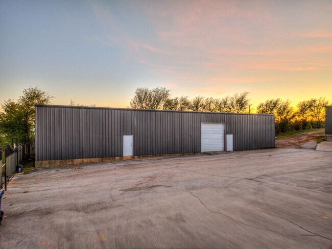
Property Record
2317 S Eastern Ave, Oklahoma City, OK 73129
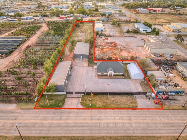

This Property Is For Sale
NEARBY LISTINGS FOR SALE OR LEASE
Property Detail
2317 S Eastern Ave
Oklahoma City, OK
Trosper Addition
143170650
TROSPER ADDITION 009 000 PT LOT 1 BEG SE/C TH N120FT W160FT S120FT E160FT TO BEG PLUS N100FT OF LOTS 3 & 4
Warehouse
Oklahoma
X
Oklahoma
40109C0305H
1
2023
3.28 AC
2024
Southeast
105300
Oklahoma City
9,928 SF
DEMOGRAPHICS near 2317 S Eastern Ave
1 Mile
3 Mile
5 Mile
2024 Total Population
2,175
65,227
199,770
2029 Population
2,237
67,404
206,975
Pop Growth 2024-2029
+ 2.85%
+ 3.34%
+ 3.61%
Average Age
34
36
36
2024 Total Households
780
25,326
78,533
HH Growth 2024-2029
+ 3.08%
+ 3.47%
+ 3.66%
Median Household Inc
$41,184
$40,560
$43,898
Avg Household Size
2.70
2.50
2.40
2024 Avg HH Vehicles
2.00
2.00
2.00
Median Home Value
$58,152
$78,889
$98,597
Median Year Built
1956
1968
1965
Nearby Places
Map Layers
Map Styles
 Street
 Aerial
- Restaurants
- Banks
- Shops
- Fitness
- Groceries
PUBLIC TRANSPORTATION
COMMUTER RAIL
Oklahoma City (Heartland Flyer - Amtrak)
DRIVE
WALK
Distance
Oklahoma City (Heartland Flyer - Amtrak)
6 min
3.5 mi
AIRPORT
Will Rogers World
DRIVE
WALK
Distance
Will Rogers World
23 min
12.3 mi
Freight Ports
Tulsa Port Of Catoosa
DRIVE
WALK
Distance
Tulsa Port Of Catoosa
134 min
123.4 mi
Nearby Properties
Address
Land Use
TOTAL SIZE
Lot Size
Zoning
Address
Land Use
TOTAL SIZE
Lot Size
Zoning
3,029,769 SF
7.21 AC
DBD
Address
Land Use
TOTAL SIZE
Lot Size
Zoning
187,346 SF
13.75 AC
PUD
Address
Land Use
TOTAL SIZE
Lot Size
Zoning
1,376,216 SF
3.22 AC
DBD
Address
Land Use
TOTAL SIZE
Lot Size
Zoning
52,331 SF
2.72 AC
DBD
Address
Land Use
TOTAL SIZE
Lot Size
Zoning
324,688 SF
1.36 AC
DBD
Address
Land Use
TOTAL SIZE
Lot Size
Zoning
101,216 SF
1.23 AC
Address
Land Use
TOTAL SIZE
Lot Size
Zoning
951,493 SF
2.24 AC
DBD
Address
Land Use
TOTAL SIZE
Lot Size
Zoning
628,486 SF
0.53 AC
DBD
Address
Land Use
TOTAL SIZE
Lot Size
Zoning
511,817 SF
3.85 AC
DBD
Address
Land Use
TOTAL SIZE
Lot Size
Zoning
91,352 SF
0.68 AC
DBD
Address
Land Use
TOTAL SIZE
Lot Size
Zoning
303,589 SF
7.17 AC
PUD
Address
Land Use
TOTAL SIZE
Lot Size
Zoning
382,618 SF
5.13 AC
BC
Address
Land Use
TOTAL SIZE
Lot Size
Zoning
164,861 SF
0.32 AC
Address
Land Use
TOTAL SIZE
Lot Size
Zoning
38,866 SF
2.89 AC
DBD
Address
Land Use
TOTAL SIZE
Lot Size
Zoning
307,772 SF
1.32 AC
DBD
Address
Land Use
TOTAL SIZE
Lot Size
Zoning
281,052 SF
1.89 AC
DBD
Address
Land Use
TOTAL SIZE
Lot Size
Zoning
42,450 SF
0.32 AC
BC
Address
Land Use
TOTAL SIZE
Lot Size
Zoning
302,236 SF
2.62 AC
SPUD
Address
Land Use
TOTAL SIZE
Lot Size
Zoning
279,464 SF
1.49 AC
DBD
Address
Land Use
TOTAL SIZE
Lot Size
Zoning
188,121 SF
0.83 AC
BC
Address
Land Use
TOTAL SIZE
Lot Size
Zoning
344,045 SF
0.55 AC
DBD
Address
Land Use
TOTAL SIZE
Lot Size
Zoning
246,881 SF
1.10 AC
DBD
Address
Land Use
TOTAL SIZE
Lot Size
Zoning
502,508 SF
2.27 AC
DBD
Address
Land Use
TOTAL SIZE
Lot Size
Zoning
184,398 SF
8.09 AC
PUD
Address
Land Use
TOTAL SIZE
Lot Size
Zoning
621,489 SF
3.10 AC
DBD
Address
Land Use
TOTAL SIZE
Lot Size
Zoning
312,675 SF
25.01 AC
Address
Land Use
TOTAL SIZE
Lot Size
Zoning
150,272 SF
1.54 AC
DBD
Address
Land Use
TOTAL SIZE
Lot Size
Zoning
0.42 AC
BC
Address
Land Use
TOTAL SIZE
Lot Size
Zoning
179,874 SF
0.23 AC
DBD
Address
Land Use
TOTAL SIZE
Lot Size
Zoning
290,418 SF
0.53 AC
DBD
The World's #1 Commercial Real Estate Marketplace
Connect with us
© 2025 CoStar Group
The information above has been obtained from sources believed reliable. While we do not doubt its accuracy we have not verified it and make no guarantee, warranty or representation about it. It is your responsibility to independently confirm its accuracy and completeness. Any projections, opinions, assumptions, or estimates used are for example only and do not represent the current or future performance of the property. The value of this transaction to you depends on tax and other factors which should be evaluated by your tax, financial, and legal advisors. You and your advisors should conduct a careful, independent investigation of the property to determine to your satisfaction the suitability of the property for your needs.