Property Record
230 W 8Th St, Port Angeles, WA 98362


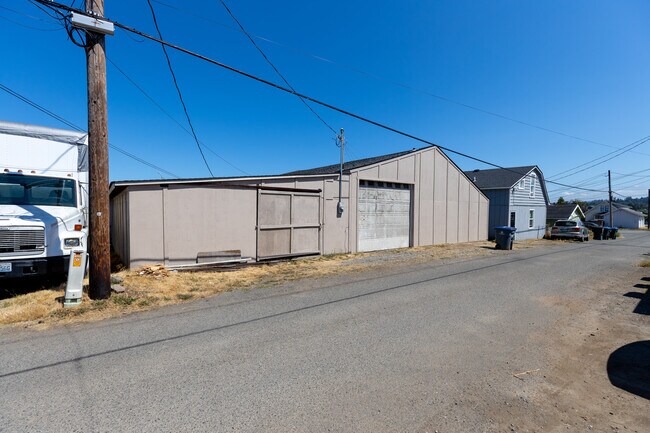
Property Detail
230 W 8Th St
58428
N2 AND W15 S2 LOT 7 AND LOT 8 BLK 266
Storebuilding
CLALLAM
PCN
Washington
B and X Area of moderate flood hazard, usually the area between the limits of the 100-year and 500-year floods.
7,8
2025
0.27 AC
2026
Bellingham/Northwest
000900
Other Market Areas
3,840 SF
Port Angeles, WA
NEARBY LISTINGS FOR SALE OR LEASE
DEMOGRAPHICS near 230 W 8Th St
1 mile
3 mile
5 mile
2025 Total Population
9,023
23,458
27,856
2030 Population
9,005
23,450
27,863
Pop Growth 2025-2030
(0.20%)
(0.03%)
+ 0.03%
Average Age
43
44
44
2025 Total Households
4,156
10,411
12,283
HH Growth 2025-2030
(0.34%)
(0.10%)
(0.07%)
Median Household Inc
$56,551
$62,949
$65,456
Avg Household Size
2.10
2.20
2.20
2025 Avg HH Vehicles
2.00
2.00
2.00
Median Home Value
$362,087
$374,398
$380,882
Median Year Built
1953
1971
1972
Nearby Places
Map Layers
Map Styles
 Street
 Aerial
Layers
 Traffic
 Biking
Places
Listings with unknown addresses are not visible on the map
- Restaurants
- Banks
- Shops
- Fitness
- Groceries
SALE & LEASE HISTORY
LISTING DATE
SALE/LEASE

Sep 03, 2021
For Lease
Jul 18, 2022
For Sale
Nearby Properties
Address
Land Use
TOTAL SIZE
Lot Size
Zoning
Address
Land Use
TOTAL SIZE
Lot Size
Zoning
15,388 SF
5.90 AC
CBD
Address
Land Use
TOTAL SIZE
Lot Size
Zoning
67,080 SF
3 AC
PIH
Address
Land Use
TOTAL SIZE
Lot Size
Zoning
65.60 AC
Address
Land Use
TOTAL SIZE
Lot Size
Zoning
63,575 SF
2.03 AC
UNC
Address
Land Use
TOTAL SIZE
Lot Size
Zoning
33,120 SF
2.50 AC
PCSD
Address
Land Use
TOTAL SIZE
Lot Size
Zoning
47,287 SF
4.73 AC
PCSD
Address
Land Use
TOTAL SIZE
Lot Size
Zoning
55,164 SF
4.29 AC
PCSD
Address
Land Use
TOTAL SIZE
Lot Size
Zoning
44,076 SF
3.29 AC
UNC
Address
Land Use
TOTAL SIZE
Lot Size
Zoning
18,410 SF
0.64 AC
CSD
Address
Land Use
TOTAL SIZE
Lot Size
Zoning
16,280 SF
0.81 AC
Address
Land Use
TOTAL SIZE
Lot Size
Zoning
2,391 SF
1.93 AC
PCA
Address
Land Use
TOTAL SIZE
Lot Size
Zoning
7.60 AC
Address
Land Use
TOTAL SIZE
Lot Size
Zoning
58,145 SF
30.33 AC
M
Address
Land Use
TOTAL SIZE
Lot Size
Zoning
36,253 SF
44.94 AC
M
Address
Land Use
TOTAL SIZE
Lot Size
Zoning
32,601 SF
2.36 AC
RMD
Address
Land Use
TOTAL SIZE
Lot Size
Zoning
17,118 SF
0.60 AC
UNC
Address
Land Use
TOTAL SIZE
Lot Size
Zoning
7.60 AC
Address
Land Use
TOTAL SIZE
Lot Size
Zoning
16,693 SF
2.46 AC
PRHD
Address
Land Use
TOTAL SIZE
Lot Size
Zoning
2.64 AC
Address
Land Use
TOTAL SIZE
Lot Size
Zoning
37,166 SF
1.93 AC
RMD
Address
Land Use
TOTAL SIZE
Lot Size
Zoning
43,760 SF
1 AC
M
Address
Land Use
TOTAL SIZE
Lot Size
Zoning
30,189 SF
2.63 AC
PCA
Address
Land Use
TOTAL SIZE
Lot Size
Zoning
21,000 SF
2.09 AC
UNC
Address
Land Use
TOTAL SIZE
Lot Size
Zoning
1,196 SF
4.15 AC
RHD
Address
Land Use
TOTAL SIZE
Lot Size
Zoning
18,913 SF
0.96 AC
PCN
Address
Land Use
TOTAL SIZE
Lot Size
Zoning
Address
Land Use
TOTAL SIZE
Lot Size
Zoning
22.85 AC
IH
Address
Land Use
TOTAL SIZE
Lot Size
Zoning
Address
Land Use
TOTAL SIZE
Lot Size
Zoning
24,087 SF
13.28 AC
Address
Land Use
TOTAL SIZE
Lot Size
Zoning
27,814 SF
0.32 AC
PCBD
The World's #1 Commercial Real Estate Marketplace
Connect with us
© 2026 CoStar Group
The information above has been obtained from sources believed reliable. While we do not doubt its accuracy we have not verified it and make no guarantee, warranty or representation about it. It is your responsibility to independently confirm its accuracy and completeness. Any projections, opinions, assumptions, or estimates used are for example only and do not represent the current or future performance of the property. The value of this transaction to you depends on tax and other factors which should be evaluated by your tax, financial, and legal advisors. You and your advisors should conduct a careful, independent investigation of the property to determine to your satisfaction the suitability of the property for your needs.