Property Record
232 Barre Paxton Rd, Rutland, MA 01543

Current Lease Availabilities
NEARBY LISTINGS FOR SALE OR LEASE
-
-
View all Rutland listings for lease on LoopNet.com
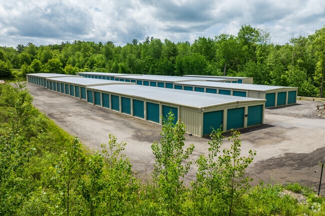
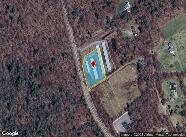
Property Detail
232 Barre Paxton Rd
RUTL-000014-C000000-000002
Worcester
Commercialbuilding
Massachusetts
X
2
25027C0580F
1.24 AC
2025
Outlying Worcester
2025
Boston
721104
Worcester, MA-CT
8,100 SF
DEMOGRAPHICS near 232 Barre Paxton Rd
1 Mile
3 Mile
5 Mile
2024 Total Population
503
6,302
15,313
2029 Population
505
6,308
15,331
Pop Growth 2024-2029
+ 0.40%
+ 0.10%
+ 0.12%
Average Age
42
41
41
2024 Total Households
199
2,359
5,477
HH Growth 2024-2029
0.00%
+ 0.08%
+ 0.11%
Median Household Inc
$95,624
$106,602
$117,577
Avg Household Size
2.50
2.70
2.70
2024 Avg HH Vehicles
2.00
2.00
2.00
Median Home Value
$360,416
$390,078
$395,751
Median Year Built
1981
1982
1981
Nearby Places
Map Layers
Map Styles
 Street
 Aerial
- Restaurants
- Banks
- Shops
- Fitness
- Groceries
PUBLIC TRANSPORTATION
AIRPORT
Worcester Regional
DRIVE
WALK
Distance
Worcester Regional
18 min
9.2 mi
Freight Ports
Port of Boston
DRIVE
WALK
Distance
Port of Boston
82 min
57.6 mi
Nearby Properties
Address
Land Use
TOTAL SIZE
Lot Size
Zoning
Address
Land Use
TOTAL SIZE
Lot Size
Zoning
61,982 SF
47.17 AC
Address
Land Use
TOTAL SIZE
Lot Size
Zoning
25,586 SF
67.88 AC
Address
Land Use
TOTAL SIZE
Lot Size
Zoning
17,543 SF
5.82 AC
Address
Land Use
TOTAL SIZE
Lot Size
Zoning
315.88 AC
R4
Address
Land Use
TOTAL SIZE
Lot Size
Zoning
30,556 SF
0.59 AC
Address
Land Use
TOTAL SIZE
Lot Size
Zoning
12,327 SF
5.49 AC
Address
Land Use
TOTAL SIZE
Lot Size
Zoning
13,727 SF
0.83 AC
Address
Land Use
TOTAL SIZE
Lot Size
Zoning
442 SF
190.08 AC
Address
Land Use
TOTAL SIZE
Lot Size
Zoning
66.49 AC
Address
Land Use
TOTAL SIZE
Lot Size
Zoning
3,056 SF
32.81 AC
Address
Land Use
TOTAL SIZE
Lot Size
Zoning
12,320 SF
9.30 AC
Address
Land Use
TOTAL SIZE
Lot Size
Zoning
4,392 SF
3.88 AC
Address
Land Use
TOTAL SIZE
Lot Size
Zoning
446 AC
Address
Land Use
TOTAL SIZE
Lot Size
Zoning
422 AC
Address
Land Use
TOTAL SIZE
Lot Size
Zoning
4,508 SF
3.72 AC
Address
Land Use
TOTAL SIZE
Lot Size
Zoning
5,775 SF
0.81 AC
Address
Land Use
TOTAL SIZE
Lot Size
Zoning
7,099 SF
4 AC
Address
Land Use
TOTAL SIZE
Lot Size
Zoning
11,542 SF
1.50 AC
Address
Land Use
TOTAL SIZE
Lot Size
Zoning
1,712 SF
1.54 AC
Address
Land Use
TOTAL SIZE
Lot Size
Zoning
4,590 SF
5.38 AC
Address
Land Use
TOTAL SIZE
Lot Size
Zoning
5,500 SF
1.22 AC
Address
Land Use
TOTAL SIZE
Lot Size
Zoning
1,014 SF
0.77 AC
Address
Land Use
TOTAL SIZE
Lot Size
Zoning
5,026 SF
1.01 AC
Address
Land Use
TOTAL SIZE
Lot Size
Zoning
8,089 SF
0.30 AC
Address
Land Use
TOTAL SIZE
Lot Size
Zoning
1,900 SF
93.35 AC
Address
Land Use
TOTAL SIZE
Lot Size
Zoning
74 AC
Address
Land Use
TOTAL SIZE
Lot Size
Zoning
130 AC
Address
Land Use
TOTAL SIZE
Lot Size
Zoning
3,740 SF
2 AC
Address
Land Use
TOTAL SIZE
Lot Size
Zoning
5,068 SF
0.38 AC
Address
Land Use
TOTAL SIZE
Lot Size
Zoning
15,256 SF
9.08 AC
The World's #1 Commercial Real Estate Marketplace
Connect with us
© 2026 CoStar Group
The information above has been obtained from sources believed reliable. While we do not doubt its accuracy we have not verified it and make no guarantee, warranty or representation about it. It is your responsibility to independently confirm its accuracy and completeness. Any projections, opinions, assumptions, or estimates used are for example only and do not represent the current or future performance of the property. The value of this transaction to you depends on tax and other factors which should be evaluated by your tax, financial, and legal advisors. You and your advisors should conduct a careful, independent investigation of the property to determine to your satisfaction the suitability of the property for your needs.