Property Record
232 Chestnut St, Brentwood, CA 94513
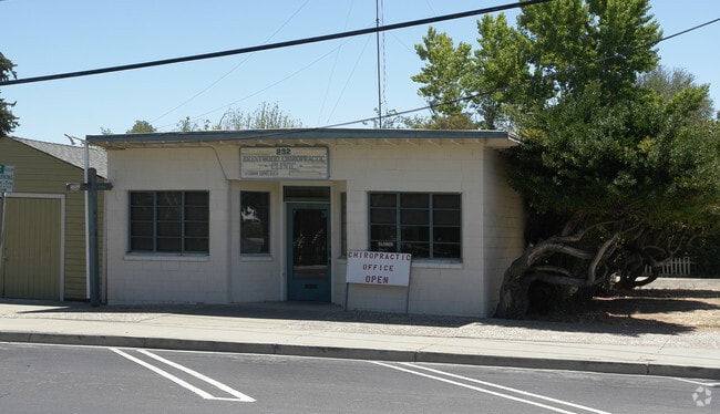


Property Detail
232 Chestnut St
Oakland-Fremont-Berkeley, CA
PORTION LOT4
013-133-019-3
CONTRA COSTA
Medicalbuilding
California
B and X Area of moderate flood hazard, usually the area between the limits of the 100-year and 500-year floods.
4
2025
0.12 AC
2025
Antioch/Pittsburg
303107
East Bay/Oakland
1,250 SF
NEARBY LISTINGS FOR SALE OR LEASE
DEMOGRAPHICS near 232 Chestnut St
1 mile
3 mile
5 mile
2025 Total Population
19,142
65,050
136,294
2030 Population
19,368
65,847
138,545
Pop Growth 2025-2030
+ 1.18%
+ 1.23%
+ 1.65%
Average Age
37
40
39
2025 Total Households
6,036
21,145
42,214
HH Growth 2025-2030
+ 1.19%
+ 1.33%
+ 1.69%
Median Household Inc
$124,933
$139,173
$139,891
Avg Household Size
3.20
3.00
3.20
2025 Avg HH Vehicles
2.00
2.00
3.00
Median Home Value
$743,131
$786,319
$760,890
Median Year Built
2000
2002
2001
Nearby Places
Map Layers
Map Styles
 Street
 Aerial
Layers
 Traffic
 Biking
Places
Listings with unknown addresses are not visible on the map
- Restaurants
- Banks
- Shops
- Fitness
- Groceries
PUBLIC TRANSPORTATION
AIRPORT
Stockton Metro
Drive
Walk
Distance
Stockton Metro
48 min
30.6 mi
Metro Oakland International
Drive
Walk
Distance
Metro Oakland International
68 min
49.8 mi
Freight Ports
Port of Stockton
Drive
Walk
Distance
Port of Stockton
44 min
28.3 mi
Nearby Properties
Address
Land Use
TOTAL SIZE
Lot Size
Zoning
Address
Land Use
TOTAL SIZE
Lot Size
Zoning
14,968 SF
7.07 AC
Address
Land Use
TOTAL SIZE
Lot Size
Zoning
129,450 SF
6.69 AC
Address
Land Use
TOTAL SIZE
Lot Size
Zoning
67,691 SF
28.26 AC
Address
Land Use
TOTAL SIZE
Lot Size
Zoning
67,133 SF
8.65 AC
Address
Land Use
TOTAL SIZE
Lot Size
Zoning
117,486 SF
7.26 AC
Address
Land Use
TOTAL SIZE
Lot Size
Zoning
15,000 SF
17.17 AC
Address
Land Use
TOTAL SIZE
Lot Size
Zoning
59,066 SF
3.89 AC
Address
Land Use
TOTAL SIZE
Lot Size
Zoning
113,902 SF
9.71 AC
Address
Land Use
TOTAL SIZE
Lot Size
Zoning
141,367 SF
4.72 AC
Address
Land Use
TOTAL SIZE
Lot Size
Zoning
107,230 SF
1.54 AC
Address
Land Use
TOTAL SIZE
Lot Size
Zoning
112,715 SF
4.48 AC
Address
Land Use
TOTAL SIZE
Lot Size
Zoning
51,980 SF
3.70 AC
Address
Land Use
TOTAL SIZE
Lot Size
Zoning
62,441 SF
5.65 AC
Address
Land Use
TOTAL SIZE
Lot Size
Zoning
65,898 SF
8.72 AC
Address
Land Use
TOTAL SIZE
Lot Size
Zoning
23,822 SF
7.16 AC
Address
Land Use
TOTAL SIZE
Lot Size
Zoning
10.44 AC
Address
Land Use
TOTAL SIZE
Lot Size
Zoning
32,198 SF
1.08 AC
Address
Land Use
TOTAL SIZE
Lot Size
Zoning
47,642 SF
3.10 AC
Address
Land Use
TOTAL SIZE
Lot Size
Zoning
36,915 SF
6.90 AC
Address
Land Use
TOTAL SIZE
Lot Size
Zoning
18,700 SF
19.01 AC
Address
Land Use
TOTAL SIZE
Lot Size
Zoning
7,818 SF
9.03 AC
Address
Land Use
TOTAL SIZE
Lot Size
Zoning
71,680 SF
4.82 AC
Address
Land Use
TOTAL SIZE
Lot Size
Zoning
6,567 SF
1.87 AC
Address
Land Use
TOTAL SIZE
Lot Size
Zoning
92,830 SF
4.45 AC
Address
Land Use
TOTAL SIZE
Lot Size
Zoning
94,156 SF
4.73 AC
Address
Land Use
TOTAL SIZE
Lot Size
Zoning
54,973 SF
5.04 AC
Address
Land Use
TOTAL SIZE
Lot Size
Zoning
45,886 SF
4.57 AC
Address
Land Use
TOTAL SIZE
Lot Size
Zoning
28,208 SF
13.75 AC
Address
Land Use
TOTAL SIZE
Lot Size
Zoning
162,909 SF
7.14 AC
Address
Land Use
TOTAL SIZE
Lot Size
Zoning
3,054 SF
1.99 AC
The World's #1 Commercial Real Estate Marketplace
Connect with us
© 2026 CoStar Group
The information above has been obtained from sources believed reliable. While we do not doubt its accuracy we have not verified it and make no guarantee, warranty or representation about it. It is your responsibility to independently confirm its accuracy and completeness. Any projections, opinions, assumptions, or estimates used are for example only and do not represent the current or future performance of the property. The value of this transaction to you depends on tax and other factors which should be evaluated by your tax, financial, and legal advisors. You and your advisors should conduct a careful, independent investigation of the property to determine to your satisfaction the suitability of the property for your needs.