Property Record
232 N 300 E, Columbus, IN 47203
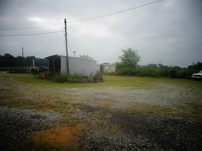

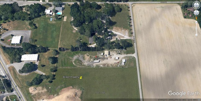
Property Detail
232 N 300 E
03-96-28-000-000.200-004
PARCEL OF LAND NE/4 NE/4, BEGINNING AT POINT ON E LINE OF NE/4 600 FT S OF NE CORNER MP 096.0000053.0000
Officebuilding
BARTHOLOMEW
B and X Area of moderate flood hazard, usually the area between the limits of the 100-year and 500-year floods.
Indiana
2024
3.09 AC
2025
Other Market Areas
011400
Columbus, IN
576 SF
NEARBY LISTINGS FOR SALE OR LEASE
DEMOGRAPHICS near 232 N 300 E
1 mile
3 mile
5 mile
2024 Total Population
1,495
25,744
46,571
2029 Population
1,546
26,412
47,798
Pop Growth 2024-2029
+ 3.41%
+ 2.59%
+ 2.63%
Average Age
40
40
40
2024 Total Households
567
11,108
19,275
HH Growth 2024-2029
+ 3.35%
+ 2.61%
+ 2.72%
Median Household Inc
$83,724
$64,147
$70,940
Avg Household Size
2.60
2.30
2.30
2024 Avg HH Vehicles
2.00
2.00
2.00
Median Home Value
$234,375
$225,213
$243,609
Median Year Built
1971
1971
1971
Nearby Places
Map Layers
Map Styles
 Street
 Aerial
Transit
 Traffic
 Biking
Places
Listings with unknown addresses are not visible on the map
- Restaurants
- Banks
- Shops
- Fitness
- Groceries
SALE & LEASE HISTORY
LISTING DATE
SALE/LEASE

Sep 24, 2016
For Sale
Jul 27, 2017
For Sale
Nearby Properties
Address
Land Use
TOTAL SIZE
Lot Size
Zoning
Address
Land Use
TOTAL SIZE
Lot Size
Zoning
539,006 SF
17.07 AC
Address
Land Use
TOTAL SIZE
Lot Size
Zoning
1,915,833 SF
49.19 AC
Address
Land Use
TOTAL SIZE
Lot Size
Zoning
126,734 SF
8.37 AC
Address
Land Use
TOTAL SIZE
Lot Size
Zoning
24,900 SF
9.76 AC
Address
Land Use
TOTAL SIZE
Lot Size
Zoning
17,880 SF
22.03 AC
Address
Land Use
TOTAL SIZE
Lot Size
Zoning
627,868 SF
47.53 AC
Address
Land Use
TOTAL SIZE
Lot Size
Zoning
73,732 SF
17.18 AC
Address
Land Use
TOTAL SIZE
Lot Size
Zoning
120,130 SF
9.22 AC
Address
Land Use
TOTAL SIZE
Lot Size
Zoning
106,400 SF
21.66 AC
Address
Land Use
TOTAL SIZE
Lot Size
Zoning
7,896 SF
14.41 AC
Address
Land Use
TOTAL SIZE
Lot Size
Zoning
207,914 SF
21.56 AC
Address
Land Use
TOTAL SIZE
Lot Size
Zoning
1,455 SF
8.33 AC
Address
Land Use
TOTAL SIZE
Lot Size
Zoning
457,838 SF
39.30 AC
Address
Land Use
TOTAL SIZE
Lot Size
Zoning
158,781 SF
20.60 AC
Address
Land Use
TOTAL SIZE
Lot Size
Zoning
2,128 SF
16.60 AC
Address
Land Use
TOTAL SIZE
Lot Size
Zoning
50,885 SF
11.71 AC
Address
Land Use
TOTAL SIZE
Lot Size
Zoning
2,186 SF
7.83 AC
Address
Land Use
TOTAL SIZE
Lot Size
Zoning
17,984 SF
27 AC
Address
Land Use
TOTAL SIZE
Lot Size
Zoning
20,700 SF
4.74 AC
Address
Land Use
TOTAL SIZE
Lot Size
Zoning
1,696 SF
9 AC
Address
Land Use
TOTAL SIZE
Lot Size
Zoning
144,601 SF
15.69 AC
Address
Land Use
TOTAL SIZE
Lot Size
Zoning
126,761 SF
11.62 AC
Address
Land Use
TOTAL SIZE
Lot Size
Zoning
1,440 SF
5.10 AC
Address
Land Use
TOTAL SIZE
Lot Size
Zoning
35,340 SF
3.54 AC
Address
Land Use
TOTAL SIZE
Lot Size
Zoning
7,403 SF
7.75 AC
Address
Land Use
TOTAL SIZE
Lot Size
Zoning
2,561 SF
4.51 AC
Address
Land Use
TOTAL SIZE
Lot Size
Zoning
2,142 SF
2.16 AC
Address
Land Use
TOTAL SIZE
Lot Size
Zoning
5,856 SF
6.10 AC
Address
Land Use
TOTAL SIZE
Lot Size
Zoning
96,066 SF
12.93 AC
Address
Land Use
TOTAL SIZE
Lot Size
Zoning
236,776 SF
15.91 AC
The World's #1 Commercial Real Estate Marketplace
Connect with us
© 2026 CoStar Group
The information above has been obtained from sources believed reliable. While we do not doubt its accuracy we have not verified it and make no guarantee, warranty or representation about it. It is your responsibility to independently confirm its accuracy and completeness. Any projections, opinions, assumptions, or estimates used are for example only and do not represent the current or future performance of the property. The value of this transaction to you depends on tax and other factors which should be evaluated by your tax, financial, and legal advisors. You and your advisors should conduct a careful, independent investigation of the property to determine to your satisfaction the suitability of the property for your needs.