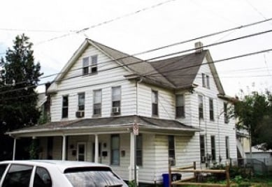
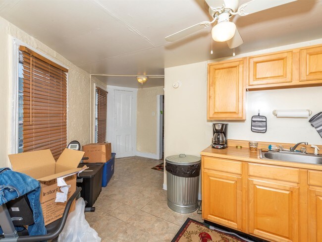
Property Record
232 State St, Enola, PA 17025
NEARBY LISTINGS FOR SALE OR LEASE
Property Detail
232 State St
Harrisburg-Carlisle, PA
Mays Addition
45-17-1044-196
PO LOT 7
Apartment
Cumberland
X
Pennsylvania
42041C0118F
7
2025
0.03 AC
2025
West Shore/Mechanicsburg
010300
Philadelphia
DEMOGRAPHICS near 232 State St
1 Mile
3 Mile
5 Mile
2024 Total Population
7,508
86,057
193,600
2029 Population
8,032
90,798
202,656
Pop Growth 2024-2029
+ 6.98%
+ 5.51%
+ 4.68%
Average Age
39
39
40
2024 Total Households
3,338
37,225
79,792
HH Growth 2024-2029
+ 7.25%
+ 5.65%
+ 4.97%
Median Household Inc
$71,872
$66,345
$70,667
Avg Household Size
2.20
2.20
2.30
2024 Avg HH Vehicles
2.00
1.00
2.00
Median Home Value
$174,048
$197,606
$199,900
Median Year Built
1969
1959
1963
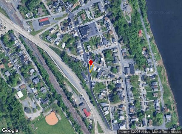
Nearby Places
Map Layers
Map Styles
 Street
 Aerial
- Restaurants
- Banks
- Shops
- Fitness
- Groceries
PUBLIC TRANSPORTATION
COMMUTER RAIL
Harrisburg (Keystone Service - Amtrak, Pennsylvanian - Amtrak)
DRIVE
WALK
Distance
Harrisburg (Keystone Service - Amtrak, Pennsylvanian - Amtrak)
7 min
3.5 mi
AIRPORT
Harrisburg International
DRIVE
WALK
Distance
Harrisburg International
24 min
14.0 mi
Freight Ports
Port of Baltimore
DRIVE
WALK
Distance
Port of Baltimore
113 min
81.9 mi
SALE & LEASE HISTORY
LISTING DATE
SALE/LEASE

Jan 07, 2020
For Sale
Nearby Properties
Address
Land Use
TOTAL SIZE
Lot Size
Zoning
Address
Land Use
TOTAL SIZE
Lot Size
Zoning
474,282 SF
4.71 AC
Address
Land Use
TOTAL SIZE
Lot Size
Zoning
22.15 AC
Address
Land Use
TOTAL SIZE
Lot Size
Zoning
615,797 SF
59.70 AC
Address
Land Use
TOTAL SIZE
Lot Size
Zoning
72.78 AC
Address
Land Use
TOTAL SIZE
Lot Size
Zoning
3,025 SF
274.13 AC
Address
Land Use
TOTAL SIZE
Lot Size
Zoning
725,856 SF
2.15 AC
Address
Land Use
TOTAL SIZE
Lot Size
Zoning
372,234 SF
1.01 AC
Address
Land Use
TOTAL SIZE
Lot Size
Zoning
40.97 AC
Address
Land Use
TOTAL SIZE
Lot Size
Zoning
482,564 SF
5 AC
Address
Land Use
TOTAL SIZE
Lot Size
Zoning
35.15 AC
Address
Land Use
TOTAL SIZE
Lot Size
Zoning
577,075 SF
39.55 AC
Address
Land Use
TOTAL SIZE
Lot Size
Zoning
0.67 AC
Address
Land Use
TOTAL SIZE
Lot Size
Zoning
1,155,340 SF
3.94 AC
Address
Land Use
TOTAL SIZE
Lot Size
Zoning
38.26 AC
Address
Land Use
TOTAL SIZE
Lot Size
Zoning
638,721 SF
47.78 AC
Address
Land Use
TOTAL SIZE
Lot Size
Zoning
349,587 SF
0.53 AC
Address
Land Use
TOTAL SIZE
Lot Size
Zoning
307,080 SF
25 AC
Address
Land Use
TOTAL SIZE
Lot Size
Zoning
329,377 SF
1.66 AC
Address
Land Use
TOTAL SIZE
Lot Size
Zoning
30.87 AC
Address
Land Use
TOTAL SIZE
Lot Size
Zoning
725 SF
19.33 AC
Address
Land Use
TOTAL SIZE
Lot Size
Zoning
9.37 AC
Address
Land Use
TOTAL SIZE
Lot Size
Zoning
352,350 SF
2.90 AC
Address
Land Use
TOTAL SIZE
Lot Size
Zoning
125,255 SF
26.65 AC
Address
Land Use
TOTAL SIZE
Lot Size
Zoning
79.43 AC
Address
Land Use
TOTAL SIZE
Lot Size
Zoning
215,800 SF
16 AC
Address
Land Use
TOTAL SIZE
Lot Size
Zoning
358,680 SF
3.79 AC
Address
Land Use
TOTAL SIZE
Lot Size
Zoning
186,900 SF
Address
Land Use
TOTAL SIZE
Lot Size
Zoning
167,935 SF
0.57 AC
Address
Land Use
TOTAL SIZE
Lot Size
Zoning
218,468 SF
0.76 AC
Address
Land Use
TOTAL SIZE
Lot Size
Zoning
13.57 AC
The World's #1 Commercial Real Estate Marketplace
Connect with us
© 2025 CoStar Group
The information above has been obtained from sources believed reliable. While we do not doubt its accuracy we have not verified it and make no guarantee, warranty or representation about it. It is your responsibility to independently confirm its accuracy and completeness. Any projections, opinions, assumptions, or estimates used are for example only and do not represent the current or future performance of the property. The value of this transaction to you depends on tax and other factors which should be evaluated by your tax, financial, and legal advisors. You and your advisors should conduct a careful, independent investigation of the property to determine to your satisfaction the suitability of the property for your needs.