Property Record
232 Sw 8Th St, Miami, FL 33130
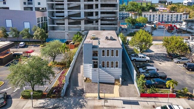


Property Detail
232 Sw 8Th St
01-0205-080-1030
CITY OF MIAMI SOUTH PB B-41 LOT 5 LESS N10FT FOR R/W BLK 58 LOT SIZE 50.000 X 140 OR 17499-2838 0197 1
Officebuilding
Miami-Dade
6402
Florida
B and X Area of moderate flood hazard, usually the area between the limits of the 100-year and 500-year floods.
5
2025
0.16 AC
2025
Brickell
006604
South Florida
11,287 SF
Miami-Miami Beach-Kendall, FL
NEARBY LISTINGS FOR SALE OR LEASE
DEMOGRAPHICS near 232 Sw 8Th St
1 mile
3 mile
5 mile
2025 Total Population
94,730
276,242
535,593
2030 Population
103,753
300,536
582,649
Pop Growth 2025-2030
+ 9.52%
+ 8.79%
+ 8.79%
Average Age
40
41
41
2025 Total Households
46,974
124,498
235,258
HH Growth 2025-2030
+ 9.31%
+ 9.04%
+ 9.12%
Median Household Inc
$99,676
$74,680
$69,694
Avg Household Size
1.90
2.10
2.20
2025 Avg HH Vehicles
1.00
1.00
1.00
Median Home Value
$688,736
$675,324
$657,468
Median Year Built
2003
1994
1978
Nearby Places
Map Layers
Map Styles
 Street
 Aerial
Layers
 Traffic
 Biking
Places
Listings with unknown addresses are not visible on the map
- Restaurants
- Banks
- Shops
- Fitness
- Groceries
PUBLIC TRANSPORTATION
TRANSIT/SUBWAY
Brickell (Metrorail) (Metrorail Green Line - Miami-Dade Transit (Metrorail/Metromover))
Drive
Walk
Distance
Brickell (Metrorail) (Metrorail Green Line - Miami-Dade Transit (Metrorail/Metromover))
1 min
7 min
0.4 mi
Eighth Street (Metromover Brickell Loop - Miami-Dade Transit (Metrorail/Metromover))
Drive
Walk
Distance
Eighth Street (Metromover Brickell Loop - Miami-Dade Transit (Metrorail/Metromover))
1 min
9 min
0.4 mi
Brickell (Metromover) (Metromover Brickell Loop - Miami-Dade Transit (Metrorail/Metromover))
Drive
Walk
Distance
Brickell (Metromover) (Metromover Brickell Loop - Miami-Dade Transit (Metrorail/Metromover))
1 min
9 min
0.4 mi
Tenth Street/Promenade (Metromover Brickell Loop - Miami-Dade Transit (Metrorail/Metromover))
Drive
Walk
Distance
Tenth Street/Promenade (Metromover Brickell Loop - Miami-Dade Transit (Metrorail/Metromover))
2 min
10 min
0.5 mi
Fifth Street (Metromover Brickell Loop - Miami-Dade Transit (Metrorail/Metromover))
Drive
Walk
Distance
Fifth Street (Metromover Brickell Loop - Miami-Dade Transit (Metrorail/Metromover))
2 min
11 min
0.6 mi
COMMUTER RAIL
Brickell (Metrorail) (Metrorail Green Line - Miami-Dade Transit (Metrorail/Metromover))
Drive
Walk
Distance
Brickell (Metrorail) (Metrorail Green Line - Miami-Dade Transit (Metrorail/Metromover))
1 min
7 min
0.4 mi
Government Center (Metromover Brickell Loop - Miami-Dade Transit (Metrorail/Metromover), Metromover Downtown Loop - Miami-Dade Transit (Metrorail/Metromover), Metromover Omni Loop - Miami-Dade Transit (Metrorail/Metromover), Metrorail Green Line - Miami-Dade Transit (Metrorail/Metromover))
Drive
Walk
Distance
Government Center (Metromover Brickell Loop - Miami-Dade Transit (Metrorail/Metromover), Metromover Downtown Loop - Miami-Dade Transit (Metrorail/Metromover), Metromover Omni Loop - Miami-Dade Transit (Metrorail/Metromover), Metrorail Green Line - Miami-Dade Transit (Metrorail/Metromover))
3 min
18 min
0.9 mi
AIRPORT
Miami International
Drive
Walk
Distance
Miami International
24 min
12.4 mi
Fort Lauderdale/Hollywood International
Drive
Walk
Distance
Fort Lauderdale/Hollywood International
35 min
24.1 mi
Freight Ports
Port of Miami
Drive
Walk
Distance
Port of Miami
9 min
3.2 mi
SALE & LEASE HISTORY
LISTING DATE
SALE/LEASE

Sep 24, 2016
For Sale
Sep 24, 2016
For Sale
Sep 20, 2017
For Lease
Oct 31, 2017
For Lease
May 31, 2018
For Sale
May 03, 2021
For Sale
Jun 19, 2025
For Sale
Jul 27, 2018
For Sale
Jan 23, 2020
For Sale
Jan 11, 2017
For Sale
Nearby Properties
Address
Land Use
TOTAL SIZE
Lot Size
Zoning
Address
Land Use
TOTAL SIZE
Lot Size
Zoning
1,050,691 SF
0.83 AC
6408
Address
Land Use
TOTAL SIZE
Lot Size
Zoning
4,758,614 SF
810.91 AC
8000
Address
Land Use
TOTAL SIZE
Lot Size
Zoning
955,966 SF
38.91 AC
9600
Address
Land Use
TOTAL SIZE
Lot Size
Zoning
2,559,318 SF
2.21 AC
6407
Address
Land Use
TOTAL SIZE
Lot Size
Zoning
2,039,308 SF
2.46 AC
6401
Address
Land Use
TOTAL SIZE
Lot Size
Zoning
928,000 SF
14.30 AC
8000
Address
Land Use
TOTAL SIZE
Lot Size
Zoning
1,110,657 SF
3.83 AC
6407
Address
Land Use
TOTAL SIZE
Lot Size
Zoning
1,346,294 SF
1.89 AC
6408
Address
Land Use
TOTAL SIZE
Lot Size
Zoning
2,403,353 SF
7.37 AC
6100
Address
Land Use
TOTAL SIZE
Lot Size
Zoning
1,938,271 SF
6.62 AC
6402
Address
Land Use
TOTAL SIZE
Lot Size
Zoning
1,162,113 SF
1.92 AC
6407
Address
Land Use
TOTAL SIZE
Lot Size
Zoning
1,075,124 SF
1.61 AC
6405
Address
Land Use
TOTAL SIZE
Lot Size
Zoning
1,544,491 SF
0.97 AC
6401
Address
Land Use
TOTAL SIZE
Lot Size
Zoning
782,686 SF
0.06 AC
6401
Address
Land Use
TOTAL SIZE
Lot Size
Zoning
1,657,362 SF
1.15 AC
6401
Address
Land Use
TOTAL SIZE
Lot Size
Zoning
1,072,012 SF
1.78 AC
6407
Address
Land Use
TOTAL SIZE
Lot Size
Zoning
244,533 SF
3.53 AC
6600
Address
Land Use
TOTAL SIZE
Lot Size
Zoning
694,863 SF
1.90 AC
6407
Address
Land Use
TOTAL SIZE
Lot Size
Zoning
656,821 SF
2.06 AC
6407
Address
Land Use
TOTAL SIZE
Lot Size
Zoning
303,989 SF
1.47 AC
6600
Address
Land Use
TOTAL SIZE
Lot Size
Zoning
416,675 SF
6.48 AC
6401
Address
Land Use
TOTAL SIZE
Lot Size
Zoning
1,004,006 SF
0.92 AC
6401
Address
Land Use
TOTAL SIZE
Lot Size
Zoning
2.50 AC
6407
Address
Land Use
TOTAL SIZE
Lot Size
Zoning
585,775 SF
1.86 AC
6101
Address
Land Use
TOTAL SIZE
Lot Size
Zoning
868,860 SF
2.14 AC
6402
Address
Land Use
TOTAL SIZE
Lot Size
Zoning
491,308 SF
0.14 AC
6401
Address
Land Use
TOTAL SIZE
Lot Size
Zoning
903,993 SF
0.60 AC
6412
Address
Land Use
TOTAL SIZE
Lot Size
Zoning
872,245 SF
0.56 AC
6401
Address
Land Use
TOTAL SIZE
Lot Size
Zoning
727,757 SF
0.64 AC
6408
Address
Land Use
TOTAL SIZE
Lot Size
Zoning
2 AC
8000
The World's #1 Commercial Real Estate Marketplace
Connect with us
© 2026 CoStar Group
The information above has been obtained from sources believed reliable. While we do not doubt its accuracy we have not verified it and make no guarantee, warranty or representation about it. It is your responsibility to independently confirm its accuracy and completeness. Any projections, opinions, assumptions, or estimates used are for example only and do not represent the current or future performance of the property. The value of this transaction to you depends on tax and other factors which should be evaluated by your tax, financial, and legal advisors. You and your advisors should conduct a careful, independent investigation of the property to determine to your satisfaction the suitability of the property for your needs.