Property Record
W Red Cross Rd, Oakboro, NC 28129

NEARBY LISTINGS FOR SALE OR LEASE
-
-
View all Oakboro listings for sale on LoopNet.com
Property Detail
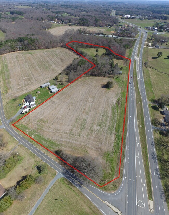
W Red Cross Rd
5595-01-45-8631
VAC W RED CROSS RD 559500385
Vacantlandnec
Stanly
X
North Carolina
3710558400J
8.25 AC
2025
Stanly County
2025
Charlotte
930902
Albemarle, NC
DEMOGRAPHICS near W Red Cross Rd
1 Mile
3 Mile
5 Mile
2024 Total Population
575
4,942
15,796
2029 Population
623
5,326
17,122
Pop Growth 2024-2029
+ 8.35%
+ 7.77%
+ 8.39%
Average Age
41
41
41
2024 Total Households
227
1,948
6,290
HH Growth 2024-2029
+ 7.93%
+ 7.60%
+ 8.17%
Median Household Inc
$56,399
$60,833
$62,898
Avg Household Size
2.50
2.50
2.50
2024 Avg HH Vehicles
2.00
3.00
2.00
Median Home Value
$198,700
$197,170
$225,632
Median Year Built
1991
1990
1990
Nearby Places
Map Layers
Map Styles
 Street
 Aerial
- Restaurants
- Banks
- Shops
- Fitness
- Groceries
PUBLIC TRANSPORTATION
AIRPORT
Concord-Padgett Regional
DRIVE
WALK
Distance
Concord-Padgett Regional
46 min
32.4 mi
Charlotte/Douglas International
DRIVE
WALK
Distance
Charlotte/Douglas International
61 min
37.9 mi
SALE & LEASE HISTORY
LISTING DATE
SALE/LEASE

Sep 25, 2016
For Lease
May 13, 2020
For Sale
Nearby Properties
Address
Land Use
TOTAL SIZE
Lot Size
Zoning
Address
Land Use
TOTAL SIZE
Lot Size
Zoning
59,734 SF
31.33 AC
R-A
Address
Land Use
TOTAL SIZE
Lot Size
Zoning
84,210 SF
38.09 AC
R-A
Address
Land Use
TOTAL SIZE
Lot Size
Zoning
40,059 SF
14.23 AC
R-20
Address
Land Use
TOTAL SIZE
Lot Size
Zoning
10,594 SF
7.33 AC
CBI
Address
Land Use
TOTAL SIZE
Lot Size
Zoning
23,218 SF
9.96 AC
Address
Land Use
TOTAL SIZE
Lot Size
Zoning
2,211 SF
31.50 AC
MULTIPLE
Address
Land Use
TOTAL SIZE
Lot Size
Zoning
43.19 AC
R-A
Address
Land Use
TOTAL SIZE
Lot Size
Zoning
9,785 SF
9.30 AC
R-20
Address
Land Use
TOTAL SIZE
Lot Size
Zoning
3,362 SF
21.06 AC
Address
Land Use
TOTAL SIZE
Lot Size
Zoning
17,883 SF
1.50 AC
RA
Address
Land Use
TOTAL SIZE
Lot Size
Zoning
12,796 SF
3.77 AC
MULTIPLE
Address
Land Use
TOTAL SIZE
Lot Size
Zoning
7,764 SF
5.33 AC
OPS
Address
Land Use
TOTAL SIZE
Lot Size
Zoning
18 AC
R-A
Address
Land Use
TOTAL SIZE
Lot Size
Zoning
9,100 SF
1.11 AC
H-B
Address
Land Use
TOTAL SIZE
Lot Size
Zoning
18,000 SF
108.20 AC
Address
Land Use
TOTAL SIZE
Lot Size
Zoning
12,141 SF
4.51 AC
MULTIPLE
Address
Land Use
TOTAL SIZE
Lot Size
Zoning
14,400 SF
2.47 AC
G-B
Address
Land Use
TOTAL SIZE
Lot Size
Zoning
2,657 SF
12.57 AC
Address
Land Use
TOTAL SIZE
Lot Size
Zoning
5,507 SF
8.51 AC
R-20
Address
Land Use
TOTAL SIZE
Lot Size
Zoning
11,785 SF
42.23 AC
MULTIPLE
Address
Land Use
TOTAL SIZE
Lot Size
Zoning
16,000 SF
1.62 AC
G-B
Address
Land Use
TOTAL SIZE
Lot Size
Zoning
7,380 SF
4.50 AC
HB
Address
Land Use
TOTAL SIZE
Lot Size
Zoning
1,155 SF
15 AC
G-B
Address
Land Use
TOTAL SIZE
Lot Size
Zoning
6,000 SF
33.89 AC
RA
Address
Land Use
TOTAL SIZE
Lot Size
Zoning
9.84 AC
R-A
Address
Land Use
TOTAL SIZE
Lot Size
Zoning
2,979 SF
1.63 AC
Address
Land Use
TOTAL SIZE
Lot Size
Zoning
3,054 SF
1.09 AC
R-20
Address
Land Use
TOTAL SIZE
Lot Size
Zoning
8,130 SF
2.74 AC
Address
Land Use
TOTAL SIZE
Lot Size
Zoning
4,500 SF
8.44 AC
Address
Land Use
TOTAL SIZE
Lot Size
Zoning
18,260 SF
1.99 AC
R-20
The World's #1 Commercial Real Estate Marketplace
Connect with us
© 2025 CoStar Group
The information above has been obtained from sources believed reliable. While we do not doubt its accuracy we have not verified it and make no guarantee, warranty or representation about it. It is your responsibility to independently confirm its accuracy and completeness. Any projections, opinions, assumptions, or estimates used are for example only and do not represent the current or future performance of the property. The value of this transaction to you depends on tax and other factors which should be evaluated by your tax, financial, and legal advisors. You and your advisors should conduct a careful, independent investigation of the property to determine to your satisfaction the suitability of the property for your needs.