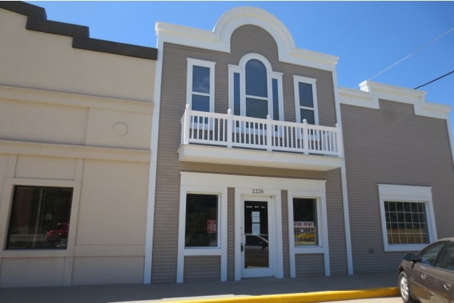
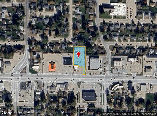
Property Record
2320 1/2 23Rd St, Columbus, NE 68601
NEARBY LISTINGS FOR SALE OR LEASE
Property Detail
2320 1/2 23Rd St
Columbus, NE
Mahood
710097692
PT LOT 20 & E22'1 LOT 21 BLK E MAHOOD COLUMBUS
Officebuilding
Platte
X
Nebraska
31037C0225D
20,21
2024
0.71 AC
2025
Nebraska Area
965400
Other Market Areas
3,965 SF
DEMOGRAPHICS near 2320 1/2 23Rd St
1 mile
3 mile
5 mile
2024 Total Population
10,579
25,948
28,629
2029 Population
10,600
26,029
28,730
Pop Growth 2024-2029
+ 0.20%
+ 0.31%
+ 0.35%
Average Age
39
39
39
2024 Total Households
4,247
10,137
11,125
HH Growth 2024-2029
+ 0.24%
+ 0.33%
+ 0.36%
Median Household Inc
$56,687
$62,855
$64,153
Avg Household Size
2.40
2.50
2.50
2024 Avg HH Vehicles
2.00
2.00
2.00
Median Home Value
$170,568
$175,252
$177,999
Median Year Built
1965
1972
1972
Nearby Places
Map Layers
Map Styles
 Street
 Aerial
Transit
 Traffic
 Biking
Places
Listings with unknown addresses are not visible on the map
- Restaurants
- Banks
- Shops
- Fitness
- Groceries
SALE & LEASE HISTORY
LISTING DATE
SALE/LEASE

Sep 25, 2016
For Lease
Nearby Properties
Address
Land Use
TOTAL SIZE
Lot Size
Zoning
Address
Land Use
TOTAL SIZE
Lot Size
Zoning
124,771 SF
3.30 AC
04-INDUSTR
Address
Land Use
TOTAL SIZE
Lot Size
Zoning
2,944 SF
7.37 AC
03-COMMERC
Address
Land Use
TOTAL SIZE
Lot Size
Zoning
99,556 SF
1 AC
04-INDUSTR
Address
Land Use
TOTAL SIZE
Lot Size
Zoning
222,895 SF
2.55 AC
03-COMMERC
Address
Land Use
TOTAL SIZE
Lot Size
Zoning
121,000 SF
1.62 AC
04-INDUSTR
Address
Land Use
TOTAL SIZE
Lot Size
Zoning
161,640 SF
15 AC
03-COMMERC
Address
Land Use
TOTAL SIZE
Lot Size
Zoning
201,720 SF
1 AC
04-INDUSTR
Address
Land Use
TOTAL SIZE
Lot Size
Zoning
13,688 SF
5.86 AC
02-MULTI-F
Address
Land Use
TOTAL SIZE
Lot Size
Zoning
68,614 SF
1 AC
03-COMMERC
Address
Land Use
TOTAL SIZE
Lot Size
Zoning
47,120 SF
5.96 AC
03-COMMERC
Address
Land Use
TOTAL SIZE
Lot Size
Zoning
38,519 SF
3.75 AC
03-COMMERC
Address
Land Use
TOTAL SIZE
Lot Size
Zoning
76,800 SF
2.04 AC
03-COMMERC
Address
Land Use
TOTAL SIZE
Lot Size
Zoning
64,860 SF
2.92 AC
03-COMMERC
Address
Land Use
TOTAL SIZE
Lot Size
Zoning
8,364 SF
3.30 AC
02-MULTI-F
Address
Land Use
TOTAL SIZE
Lot Size
Zoning
34,885 SF
18.25 AC
03-COMMERC
Address
Land Use
TOTAL SIZE
Lot Size
Zoning
70,212 SF
6.81 AC
03-COMMERC
Address
Land Use
TOTAL SIZE
Lot Size
Zoning
63,927 SF
5.71 AC
04-INDUSTR
Address
Land Use
TOTAL SIZE
Lot Size
Zoning
90,056 SF
03-COMMERC
Address
Land Use
TOTAL SIZE
Lot Size
Zoning
16,845 SF
5.72 AC
03-COMMERC
Address
Land Use
TOTAL SIZE
Lot Size
Zoning
23,664 SF
3.29 AC
02-MULTI-F
Address
Land Use
TOTAL SIZE
Lot Size
Zoning
46,135 SF
16.30 AC
04-INDUSTR
Address
Land Use
TOTAL SIZE
Lot Size
Zoning
42,980 SF
2.74 AC
03-COMMERC
Address
Land Use
TOTAL SIZE
Lot Size
Zoning
20,800 SF
3.06 AC
03-COMMERC
Address
Land Use
TOTAL SIZE
Lot Size
Zoning
28,891 SF
6.07 AC
03-COMMERC
Address
Land Use
TOTAL SIZE
Lot Size
Zoning
50,864 SF
1.79 AC
03-COMMERC
Address
Land Use
TOTAL SIZE
Lot Size
Zoning
68,614 SF
10.01 AC
03-COMMERC
Address
Land Use
TOTAL SIZE
Lot Size
Zoning
85,182 SF
6.17 AC
03-COMMERC
Address
Land Use
TOTAL SIZE
Lot Size
Zoning
54,466 SF
8.99 AC
03-COMMERC
The World's #1 Commercial Real Estate Marketplace
Connect with us
© 2026 CoStar Group
The information above has been obtained from sources believed reliable. While we do not doubt its accuracy we have not verified it and make no guarantee, warranty or representation about it. It is your responsibility to independently confirm its accuracy and completeness. Any projections, opinions, assumptions, or estimates used are for example only and do not represent the current or future performance of the property. The value of this transaction to you depends on tax and other factors which should be evaluated by your tax, financial, and legal advisors. You and your advisors should conduct a careful, independent investigation of the property to determine to your satisfaction the suitability of the property for your needs.