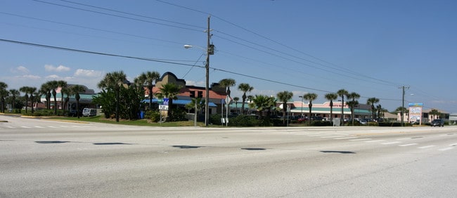
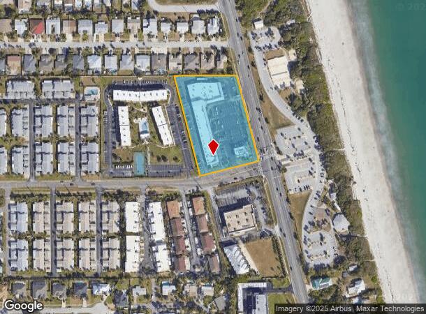
Property Record
2320 N Highway A1a, Indialantic, FL 32903

NEARBY LISTINGS FOR SALE OR LEASE
Property Detail
2320 N Highway A1a
27-37-24-00-00031.0-0000.00
PART OF GOVT LOT 6 W OF A1A AS DES IN ORB 2097 PG 453
Storebuilding
Brevard
X
Florida
12009C0602H
6
2024
3.25 AC
2025
Brevard County
066301
Orlando
37,331 SF
Palm Bay-Melbourne-Titusville, FL
DEMOGRAPHICS near 2320 N Highway A1a
1 Mile
3 Mile
5 Mile
2024 Total Population
6,460
27,399
77,020
2029 Population
7,053
29,963
84,414
Pop Growth 2024-2029
+ 9.18%
+ 9.36%
+ 9.60%
Average Age
47
47
45
2024 Total Households
2,866
12,166
33,729
HH Growth 2024-2029
+ 9.00%
+ 9.21%
+ 9.47%
Median Household Inc
$91,147
$83,321
$64,030
Avg Household Size
2.20
2.20
2.20
2024 Avg HH Vehicles
2.00
2.00
2.00
Median Home Value
$462,816
$396,162
$314,873
Median Year Built
1983
1977
1977
Nearby Places
Map Layers
Map Styles
 Street
 Aerial
- Restaurants
- Banks
- Shops
- Fitness
- Groceries
PUBLIC TRANSPORTATION
AIRPORT
Melbourne Orlando International
DRIVE
WALK
Distance
Melbourne Orlando International
20 min
8.4 mi
Freight Ports
Port Canaveral
DRIVE
WALK
Distance
Port Canaveral
41 min
20.4 mi
SALE & LEASE HISTORY
LISTING DATE
SALE/LEASE

Feb 15, 2024
For Sale
Nearby Properties
Address
Land Use
TOTAL SIZE
Lot Size
Zoning
Address
Land Use
TOTAL SIZE
Lot Size
Zoning
289,263 SF
13.96 AC
R2
Address
Land Use
TOTAL SIZE
Lot Size
Zoning
225,168 SF
7.06 AC
R3
Address
Land Use
TOTAL SIZE
Lot Size
Zoning
187,107 SF
10.87 AC
Address
Land Use
TOTAL SIZE
Lot Size
Zoning
364,027 SF
22.91 AC
C2
Address
Land Use
TOTAL SIZE
Lot Size
Zoning
147,294 SF
5.18 AC
TU1
Address
Land Use
TOTAL SIZE
Lot Size
Zoning
173,965 SF
4.28 AC
C1
Address
Land Use
TOTAL SIZE
Lot Size
Zoning
169,387 SF
28.25 AC
INL
Address
Land Use
TOTAL SIZE
Lot Size
Zoning
2,710 SF
12.04 AC
I1
Address
Land Use
TOTAL SIZE
Lot Size
Zoning
252,942 SF
29.76 AC
R3
Address
Land Use
TOTAL SIZE
Lot Size
Zoning
116,309 SF
2.56 AC
TU-1
Address
Land Use
TOTAL SIZE
Lot Size
Zoning
192,888 SF
5.66 AC
Address
Land Use
TOTAL SIZE
Lot Size
Zoning
182,969 SF
14.64 AC
B1
Address
Land Use
TOTAL SIZE
Lot Size
Zoning
118,607 SF
9.67 AC
CP
Address
Land Use
TOTAL SIZE
Lot Size
Zoning
106,333 SF
2.52 AC
B1
Address
Land Use
TOTAL SIZE
Lot Size
Zoning
135,578 SF
3.86 AC
I1
Address
Land Use
TOTAL SIZE
Lot Size
Zoning
81,119 SF
7.14 AC
BU1
Address
Land Use
TOTAL SIZE
Lot Size
Zoning
74,189 SF
4.39 AC
C2
Address
Land Use
TOTAL SIZE
Lot Size
Zoning
107,169 SF
34.23 AC
GU
Address
Land Use
TOTAL SIZE
Lot Size
Zoning
92,718 SF
11.99 AC
GU
Address
Land Use
TOTAL SIZE
Lot Size
Zoning
83,216 SF
1.95 AC
CC1
Address
Land Use
TOTAL SIZE
Lot Size
Zoning
144,052 SF
13.28 AC
B1
Address
Land Use
TOTAL SIZE
Lot Size
Zoning
742 SF
2.04 AC
GML
Address
Land Use
TOTAL SIZE
Lot Size
Zoning
52,325 SF
2.40 AC
C1
Address
Land Use
TOTAL SIZE
Lot Size
Zoning
103,298 SF
7.62 AC
C2
Address
Land Use
TOTAL SIZE
Lot Size
Zoning
45,690 SF
3.31 AC
Address
Land Use
TOTAL SIZE
Lot Size
Zoning
55,552 SF
1.50 AC
Address
Land Use
TOTAL SIZE
Lot Size
Zoning
49,180 SF
5.81 AC
C2
Address
Land Use
TOTAL SIZE
Lot Size
Zoning
81,545 SF
4.79 AC
Address
Land Use
TOTAL SIZE
Lot Size
Zoning
99,628 SF
9.97 AC
CP
Address
Land Use
TOTAL SIZE
Lot Size
Zoning
The World's #1 Commercial Real Estate Marketplace
Connect with us
© 2025 CoStar Group
The information above has been obtained from sources believed reliable. While we do not doubt its accuracy we have not verified it and make no guarantee, warranty or representation about it. It is your responsibility to independently confirm its accuracy and completeness. Any projections, opinions, assumptions, or estimates used are for example only and do not represent the current or future performance of the property. The value of this transaction to you depends on tax and other factors which should be evaluated by your tax, financial, and legal advisors. You and your advisors should conduct a careful, independent investigation of the property to determine to your satisfaction the suitability of the property for your needs.