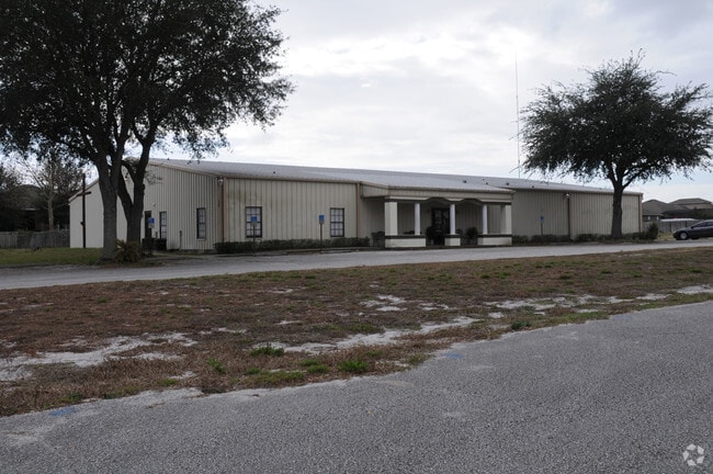
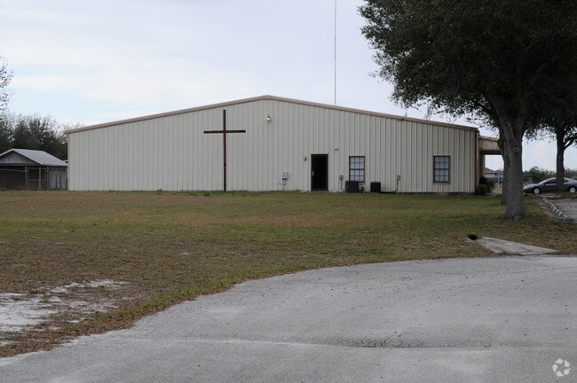
Property Record
2320 Rock Springs Rd, Apopka, FL 32712

NEARBY LISTINGS FOR SALE OR LEASE
-
-
View all Apopka listings for sale on LoopNet.com
Property Detail
2320 Rock Springs Rd
Orlando-Kissimmee-Sanford, FL
Acreage & Unrec
28-2028-0000-00-022
N1/2 OF S1/2 OF NE1/4 OF SE1/4 (LESS E 50 FT FOR SR #435) OF SEC 28-20-28
Religious
Orange
X
Florida
12095C0110H
22
2024
9.59 AC
2025
NW Orange Outlying
017809
Orlando
13,848 SF
DEMOGRAPHICS near 2320 Rock Springs Rd
1 Mile
3 Mile
5 Mile
2024 Total Population
5,598
45,319
99,666
2029 Population
5,809
46,666
103,101
Pop Growth 2024-2029
+ 3.77%
+ 2.97%
+ 3.45%
Average Age
39
40
41
2024 Total Households
1,805
14,992
34,607
HH Growth 2024-2029
+ 3.71%
+ 2.91%
+ 3.42%
Median Household Inc
$93,518
$89,092
$75,317
Avg Household Size
3.00
2.90
2.80
2024 Avg HH Vehicles
2.00
2.00
2.00
Median Home Value
$346,507
$343,260
$317,726
Median Year Built
2001
1996
1990
Nearby Places
Map Layers
Map Styles
 Street
 Aerial
- Restaurants
- Banks
- Shops
- Fitness
- Groceries
PUBLIC TRANSPORTATION
AIRPORT
Orlando Sanford International
DRIVE
WALK
Distance
Orlando Sanford International
40 min
22.9 mi
Orlando International
DRIVE
WALK
Distance
Orlando International
48 min
29.2 mi
Freight Ports
Port Canaveral
DRIVE
WALK
Distance
Port Canaveral
94 min
71.2 mi
Nearby Properties
Address
Land Use
TOTAL SIZE
Lot Size
Zoning
Address
Land Use
TOTAL SIZE
Lot Size
Zoning
792,152 SF
53.04 AC
O
Address
Land Use
TOTAL SIZE
Lot Size
Zoning
341,131 SF
39.88 AC
O
Address
Land Use
TOTAL SIZE
Lot Size
Zoning
313,324 SF
32.44 AC
PR
Address
Land Use
TOTAL SIZE
Lot Size
Zoning
83,209 SF
5,971.65 AC
A-2
Address
Land Use
TOTAL SIZE
Lot Size
Zoning
75.90 AC
MU-KPI
Address
Land Use
TOTAL SIZE
Lot Size
Zoning
67,945 SF
18.66 AC
O
Address
Land Use
TOTAL SIZE
Lot Size
Zoning
3,688 SF
71.90 AC
MU-KPI
Address
Land Use
TOTAL SIZE
Lot Size
Zoning
185,772 SF
16.70 AC
O
Address
Land Use
TOTAL SIZE
Lot Size
Zoning
178,662 SF
17.71 AC
PUD
Address
Land Use
TOTAL SIZE
Lot Size
Zoning
175,687 SF
15.13 AC
O
Address
Land Use
TOTAL SIZE
Lot Size
Zoning
108,529 SF
18.20 AC
PUD
Address
Land Use
TOTAL SIZE
Lot Size
Zoning
136,824 SF
11.66 AC
C-C
Address
Land Use
TOTAL SIZE
Lot Size
Zoning
189,143 SF
16.44 AC
O
Address
Land Use
TOTAL SIZE
Lot Size
Zoning
29 AC
D-APK-MU-K
Address
Land Use
TOTAL SIZE
Lot Size
Zoning
216,008 SF
19.20 AC
O
Address
Land Use
TOTAL SIZE
Lot Size
Zoning
104,860 SF
5.09 AC
PD
Address
Land Use
TOTAL SIZE
Lot Size
Zoning
88,655 SF
1.92 AC
RSTD C-1
Address
Land Use
TOTAL SIZE
Lot Size
Zoning
67,867 SF
7.99 AC
PUD
Address
Land Use
TOTAL SIZE
Lot Size
Zoning
14.64 AC
AG
Address
Land Use
TOTAL SIZE
Lot Size
Zoning
18,594 SF
272.21 AC
O
Address
Land Use
TOTAL SIZE
Lot Size
Zoning
98,625 SF
4.71 AC
C-C
Address
Land Use
TOTAL SIZE
Lot Size
Zoning
86,011 SF
7.94 AC
C-C
Address
Land Use
TOTAL SIZE
Lot Size
Zoning
61,725 SF
4 AC
RMF
Address
Land Use
TOTAL SIZE
Lot Size
Zoning
57,394 SF
6.54 AC
O
Address
Land Use
TOTAL SIZE
Lot Size
Zoning
108,520 SF
8.17 AC
PUD
Address
Land Use
TOTAL SIZE
Lot Size
Zoning
49,816 SF
6.82 AC
C-C
Address
Land Use
TOTAL SIZE
Lot Size
Zoning
53,172 SF
6.85 AC
PD
Address
Land Use
TOTAL SIZE
Lot Size
Zoning
51,811 SF
4.24 AC
RMF
Address
Land Use
TOTAL SIZE
Lot Size
Zoning
80,746 SF
9.20 AC
PUD
Address
Land Use
TOTAL SIZE
Lot Size
Zoning
84,054 SF
3.84 AC
PUD
The World's #1 Commercial Real Estate Marketplace
Connect with us
© 2026 CoStar Group
The information above has been obtained from sources believed reliable. While we do not doubt its accuracy we have not verified it and make no guarantee, warranty or representation about it. It is your responsibility to independently confirm its accuracy and completeness. Any projections, opinions, assumptions, or estimates used are for example only and do not represent the current or future performance of the property. The value of this transaction to you depends on tax and other factors which should be evaluated by your tax, financial, and legal advisors. You and your advisors should conduct a careful, independent investigation of the property to determine to your satisfaction the suitability of the property for your needs.