Property Record
2320 Rothsville Rd, Lititz, PA 17543


NEARBY LISTINGS FOR SALE OR LEASE
Property Detail
2320 Rothsville Rd
Lancaster, PA
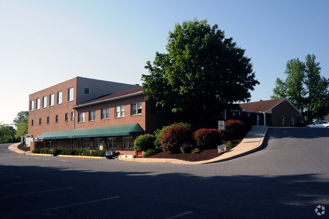
Rothsville Medical Center
600-79505-0-0000
2320 ROTHSVILLE RD
Officebuilding
Lancaster
X
Pennsylvania
42071C0188F
12
2024
3.95 AC
2025
Lancaster County
012106
Philadelphia
17,176 SF
DEMOGRAPHICS near 2320 Rothsville Rd
1 Mile
3 Mile
5 Mile
2024 Total Population
3,563
25,586
84,580
2029 Population
3,589
25,736
85,307
Pop Growth 2024-2029
+ 0.73%
+ 0.59%
+ 0.86%
Average Age
40
42
43
2024 Total Households
1,288
9,916
32,557
HH Growth 2024-2029
+ 0.85%
+ 0.58%
+ 0.94%
Median Household Inc
$91,353
$78,782
$76,904
Avg Household Size
2.70
2.50
2.50
2024 Avg HH Vehicles
2.00
2.00
2.00
Median Home Value
$255,087
$249,562
$260,082
Median Year Built
1983
1984
1981
Nearby Places
Map Layers
Map Styles
 Street
 Aerial
- Restaurants
- Banks
- Shops
- Fitness
- Groceries
PUBLIC TRANSPORTATION
AIRPORT
Harrisburg International
DRIVE
WALK
Distance
Harrisburg International
49 min
35.9 mi
Freight Ports
Port of Wilmington, RI
DRIVE
WALK
Distance
Port of Wilmington, RI
95 min
54.4 mi
Nearby Properties
Address
Land Use
TOTAL SIZE
Lot Size
Zoning
Address
Land Use
TOTAL SIZE
Lot Size
Zoning
213,584 SF
3.80 AC
CC
Address
Land Use
TOTAL SIZE
Lot Size
Zoning
148,187 SF
40 AC
R-1
Address
Land Use
TOTAL SIZE
Lot Size
Zoning
188,543 SF
26.76 AC
R-2
Address
Land Use
TOTAL SIZE
Lot Size
Zoning
94,951 SF
26.80 AC
R-1
Address
Land Use
TOTAL SIZE
Lot Size
Zoning
80,125 SF
19.27 AC
Address
Land Use
TOTAL SIZE
Lot Size
Zoning
103,448 SF
79.90 AC
A
Address
Land Use
TOTAL SIZE
Lot Size
Zoning
109,519 SF
10.50 AC
R-2
Address
Land Use
TOTAL SIZE
Lot Size
Zoning
122,512 SF
22.36 AC
I
Address
Land Use
TOTAL SIZE
Lot Size
Zoning
123,018 SF
14.30 AC
HC
Address
Land Use
TOTAL SIZE
Lot Size
Zoning
75,760 SF
4.85 AC
RMD
Address
Land Use
TOTAL SIZE
Lot Size
Zoning
92,968 SF
12.90 AC
RA
Address
Land Use
TOTAL SIZE
Lot Size
Zoning
73,648 SF
10.20 AC
R-1
Address
Land Use
TOTAL SIZE
Lot Size
Zoning
92,217 SF
11.50 AC
C
Address
Land Use
TOTAL SIZE
Lot Size
Zoning
51,954 SF
11.80 AC
R-1
Address
Land Use
TOTAL SIZE
Lot Size
Zoning
81,044 SF
4.67 AC
Address
Land Use
TOTAL SIZE
Lot Size
Zoning
36,831 SF
14.70 AC
A
Address
Land Use
TOTAL SIZE
Lot Size
Zoning
43,522 SF
15.70 AC
A
Address
Land Use
TOTAL SIZE
Lot Size
Zoning
104,828 SF
5.94 AC
I
Address
Land Use
TOTAL SIZE
Lot Size
Zoning
59,702 SF
9.20 AC
R-2
Address
Land Use
TOTAL SIZE
Lot Size
Zoning
220,374 SF
20.62 AC
I
Address
Land Use
TOTAL SIZE
Lot Size
Zoning
16,054 SF
4.50 AC
HC
Address
Land Use
TOTAL SIZE
Lot Size
Zoning
14.50 AC
I
Address
Land Use
TOTAL SIZE
Lot Size
Zoning
51,064 SF
1.28 AC
Address
Land Use
TOTAL SIZE
Lot Size
Zoning
20,116 SF
3.50 AC
HC
Address
Land Use
TOTAL SIZE
Lot Size
Zoning
34,394 SF
1.82 AC
Address
Land Use
TOTAL SIZE
Lot Size
Zoning
44,625 SF
9.61 AC
C-2
Address
Land Use
TOTAL SIZE
Lot Size
Zoning
45,024 SF
7.40 AC
R2
Address
Land Use
TOTAL SIZE
Lot Size
Zoning
46,339 SF
39 AC
RMD
Address
Land Use
TOTAL SIZE
Lot Size
Zoning
29,519 SF
9.17 AC
A
The World's #1 Commercial Real Estate Marketplace
Connect with us
© 2025 CoStar Group
The information above has been obtained from sources believed reliable. While we do not doubt its accuracy we have not verified it and make no guarantee, warranty or representation about it. It is your responsibility to independently confirm its accuracy and completeness. Any projections, opinions, assumptions, or estimates used are for example only and do not represent the current or future performance of the property. The value of this transaction to you depends on tax and other factors which should be evaluated by your tax, financial, and legal advisors. You and your advisors should conduct a careful, independent investigation of the property to determine to your satisfaction the suitability of the property for your needs.