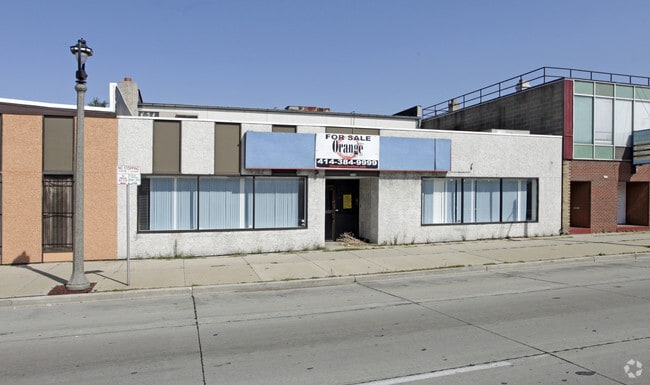
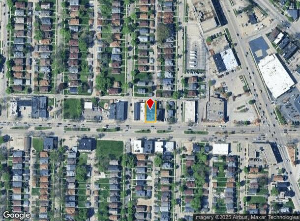
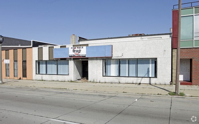
Property Record
2320 W Capitol Dr, Milwaukee, WI 53206
NEARBY LISTINGS FOR SALE OR LEASE
-
-
-
-
-
-
-
-
-
-
1801-1805 N Dr Martin Luther King Jr Dr
Milwaukee, WI 53212
$280,000 - $760,000
1,721 - 6,714 SF
Retail
-
View all Milwaukee listings for lease on LoopNet.com
Property Detail
2320 W Capitol Dr
Milwaukee-Waukesha-West Allis, WI
Lake Blvd Heights
245-2322-000-0
CERTIFIED SURVEY MAP NO 3464 IN SW 1/4 SEC 6-7-22 PARCEL 2 BID #29 BID #52
Retailwithmorethanonenonretailuse
Milwaukee
X
Wisconsin
55079C0100E
13,14
2024
0.34 AC
2024
Milwaukee NW
004200
Milwaukee/Madison
9,844 SF
DEMOGRAPHICS near 2320 W Capitol Dr
1 Mile
3 Mile
5 Mile
2024 Total Population
23,900
203,110
422,136
2029 Population
23,867
200,846
415,616
Pop Growth 2024-2029
(0.14%)
(1.11%)
(1.54%)
Average Age
37
36
36
2024 Total Households
9,373
80,928
178,962
HH Growth 2024-2029
(0.29%)
(1.31%)
(1.58%)
Median Household Inc
$30,051
$40,008
$48,639
Avg Household Size
2.50
2.40
2.20
2024 Avg HH Vehicles
1.00
1.00
1.00
Median Home Value
$70,329
$142,878
$188,589
Median Year Built
1946
1948
1949
Nearby Places
Map Layers
Map Styles
 Street
 Aerial
- Restaurants
- Banks
- Shops
- Fitness
- Groceries
PUBLIC TRANSPORTATION
COMMUTER RAIL
DRIVE
WALK
Distance
11 min
5.1 mi
AIRPORT
General Mitchell International
DRIVE
WALK
Distance
General Mitchell International
22 min
11.6 mi
Freight Ports
Port Milwaukee
DRIVE
WALK
Distance
Port Milwaukee
14 min
7.5 mi
SALE & LEASE HISTORY
LISTING DATE
SALE/LEASE

Oct 13, 2016
For Lease
Jan 26, 2017
For Lease
Feb 16, 2017
For Lease
Feb 16, 2017
For Sale
Nearby Properties
Address
Land Use
TOTAL SIZE
Lot Size
Zoning
Address
Land Use
TOTAL SIZE
Lot Size
Zoning
305,573 SF
3.20 AC
Address
Land Use
TOTAL SIZE
Lot Size
Zoning
66,245 SF
10.21 AC
Address
Land Use
TOTAL SIZE
Lot Size
Zoning
527,776 SF
33.23 AC
Address
Land Use
TOTAL SIZE
Lot Size
Zoning
0.09 AC
LB2
Address
Land Use
TOTAL SIZE
Lot Size
Zoning
0.07 AC
RS6
Address
Land Use
TOTAL SIZE
Lot Size
Zoning
12.97 AC
TL
Address
Land Use
TOTAL SIZE
Lot Size
Zoning
85,000 SF
1.13 AC
Address
Land Use
TOTAL SIZE
Lot Size
Zoning
685,390 SF
26.20 AC
Address
Land Use
TOTAL SIZE
Lot Size
Zoning
152,640 SF
10.50 AC
Address
Land Use
TOTAL SIZE
Lot Size
Zoning
171,170 SF
25.88 AC
Address
Land Use
TOTAL SIZE
Lot Size
Zoning
12.74 AC
TL
Address
Land Use
TOTAL SIZE
Lot Size
Zoning
193,988 SF
1.28 AC
C9G
Address
Land Use
TOTAL SIZE
Lot Size
Zoning
224,756 SF
12 AC
RESIDENTIA
Address
Land Use
TOTAL SIZE
Lot Size
Zoning
0.71 AC
RM2
Address
Land Use
TOTAL SIZE
Lot Size
Zoning
0.71 AC
RM2
Address
Land Use
TOTAL SIZE
Lot Size
Zoning
145,605 SF
2.64 AC
Address
Land Use
TOTAL SIZE
Lot Size
Zoning
241,520 SF
6.60 AC
Address
Land Use
TOTAL SIZE
Lot Size
Zoning
165,296 SF
1.04 AC
Address
Land Use
TOTAL SIZE
Lot Size
Zoning
294,553 SF
6.19 AC
Address
Land Use
TOTAL SIZE
Lot Size
Zoning
113,542 SF
2.31 AC
Address
Land Use
TOTAL SIZE
Lot Size
Zoning
213,218 SF
11 AC
Address
Land Use
TOTAL SIZE
Lot Size
Zoning
1.76 AC
LB2
Address
Land Use
TOTAL SIZE
Lot Size
Zoning
90,714 SF
4.18 AC
Address
Land Use
TOTAL SIZE
Lot Size
Zoning
72,121 SF
10.93 AC
TL
Address
Land Use
TOTAL SIZE
Lot Size
Zoning
195,507 SF
1.92 AC
Address
Land Use
TOTAL SIZE
Lot Size
Zoning
4.25 AC
PD
Address
Land Use
TOTAL SIZE
Lot Size
Zoning
0.80 AC
RT4
Address
Land Use
TOTAL SIZE
Lot Size
Zoning
2.15 AC
RT4
Address
Land Use
TOTAL SIZE
Lot Size
Zoning
72,676 SF
6.22 AC
Address
Land Use
TOTAL SIZE
Lot Size
Zoning
66.42 AC
IL1
The World's #1 Commercial Real Estate Marketplace
Connect with us
© 2025 CoStar Group
The information above has been obtained from sources believed reliable. While we do not doubt its accuracy we have not verified it and make no guarantee, warranty or representation about it. It is your responsibility to independently confirm its accuracy and completeness. Any projections, opinions, assumptions, or estimates used are for example only and do not represent the current or future performance of the property. The value of this transaction to you depends on tax and other factors which should be evaluated by your tax, financial, and legal advisors. You and your advisors should conduct a careful, independent investigation of the property to determine to your satisfaction the suitability of the property for your needs.