Property Record
2321 Maggard Dr, Lexington, KY 40511


NEARBY LISTINGS FOR SALE OR LEASE
Property Detail
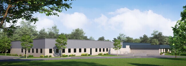
2321 Maggard Dr
Lexington-Fayette, KY
Burke Hockensmith & Maggard
38040710
L-490 BURKE HOCKENSMITH & MAGGARD UNIT 2-B LOT 4; BOOK: 3831 PAGE: 138
Warehouse
Fayette
X
Kentucky
2100670109E
4
2025
2.17 AC
2025
West Lexington/Fayette
003704
Lexington/Fayette
11,970 SF
DEMOGRAPHICS near 2321 Maggard Dr
1 Mile
3 Mile
5 Mile
2024 Total Population
5,243
55,860
138,131
2029 Population
5,330
56,466
138,866
Pop Growth 2024-2029
+ 1.66%
+ 1.08%
+ 0.53%
Average Age
37
37
37
2024 Total Households
2,044
22,499
56,719
HH Growth 2024-2029
+ 1.52%
+ 1.08%
+ 0.58%
Median Household Inc
$80,249
$55,846
$50,883
Avg Household Size
2.50
2.30
2.20
2024 Avg HH Vehicles
2.00
2.00
2.00
Median Home Value
$207,678
$193,548
$204,266
Median Year Built
2005
1993
1970
Nearby Places
Map Layers
Map Styles
 Street
 Aerial
- Restaurants
- Banks
- Shops
- Fitness
- Groceries
PUBLIC TRANSPORTATION
AIRPORT
Blue Grass
DRIVE
WALK
Distance
Blue Grass
18 min
9.8 mi
SALE & LEASE HISTORY
LISTING DATE
SALE/LEASE

Sep 27, 2022
For Lease
Apr 01, 2021
For Lease
Nearby Properties
Address
Land Use
TOTAL SIZE
Lot Size
Zoning
Address
Land Use
TOTAL SIZE
Lot Size
Zoning
14.90 AC
B-2B
Address
Land Use
TOTAL SIZE
Lot Size
Zoning
6,173 SF
301.57 AC
A-R
Address
Land Use
TOTAL SIZE
Lot Size
Zoning
1,344 SF
150.76 AC
A-U
Address
Land Use
TOTAL SIZE
Lot Size
Zoning
1.25 AC
B-2B
Address
Land Use
TOTAL SIZE
Lot Size
Zoning
163,536 SF
117.26 AC
I-1
Address
Land Use
TOTAL SIZE
Lot Size
Zoning
Address
Land Use
TOTAL SIZE
Lot Size
Zoning
292,191 SF
19.74 AC
B-5P
Address
Land Use
TOTAL SIZE
Lot Size
Zoning
61,965 SF
46.96 AC
A-U
Address
Land Use
TOTAL SIZE
Lot Size
Zoning
6,462 SF
332.36 AC
I-1
Address
Land Use
TOTAL SIZE
Lot Size
Zoning
278,944 SF
0.75 AC
B-2B
Address
Land Use
TOTAL SIZE
Lot Size
Zoning
340,698 SF
B-2B
Address
Land Use
TOTAL SIZE
Lot Size
Zoning
70.44 AC
I-1
Address
Land Use
TOTAL SIZE
Lot Size
Zoning
357,373 SF
2.43 AC
B-2B
Address
Land Use
TOTAL SIZE
Lot Size
Zoning
374,910 SF
0.78 AC
B-2B
Address
Land Use
TOTAL SIZE
Lot Size
Zoning
210 SF
46.68 AC
M-1P
Address
Land Use
TOTAL SIZE
Lot Size
Zoning
107,473 SF
17 AC
A-U
Address
Land Use
TOTAL SIZE
Lot Size
Zoning
206,496 SF
5.57 AC
R-5
Address
Land Use
TOTAL SIZE
Lot Size
Zoning
2,864 SF
7.34 AC
R-3
Address
Land Use
TOTAL SIZE
Lot Size
Zoning
16.93 AC
R-3
Address
Land Use
TOTAL SIZE
Lot Size
Zoning
441,100 SF
30 AC
I-1
Address
Land Use
TOTAL SIZE
Lot Size
Zoning
94,835 SF
21.09 AC
A-U
Address
Land Use
TOTAL SIZE
Lot Size
Zoning
Address
Land Use
TOTAL SIZE
Lot Size
Zoning
54,525 SF
25.78 AC
P-2
Address
Land Use
TOTAL SIZE
Lot Size
Zoning
255,490 SF
55.45 AC
I-1
Address
Land Use
TOTAL SIZE
Lot Size
Zoning
9.05 AC
R-3
Address
Land Use
TOTAL SIZE
Lot Size
Zoning
407,736 SF
29.54 AC
P-1
Address
Land Use
TOTAL SIZE
Lot Size
Zoning
187,120 SF
17.52 AC
I-1
Address
Land Use
TOTAL SIZE
Lot Size
Zoning
210,498 SF
18.36 AC
I-1
Address
Land Use
TOTAL SIZE
Lot Size
Zoning
73,236 SF
5.35 AC
R-4
Address
Land Use
TOTAL SIZE
Lot Size
Zoning
286,060 SF
P-2
The World's #1 Commercial Real Estate Marketplace
Connect with us
© 2025 CoStar Group
The information above has been obtained from sources believed reliable. While we do not doubt its accuracy we have not verified it and make no guarantee, warranty or representation about it. It is your responsibility to independently confirm its accuracy and completeness. Any projections, opinions, assumptions, or estimates used are for example only and do not represent the current or future performance of the property. The value of this transaction to you depends on tax and other factors which should be evaluated by your tax, financial, and legal advisors. You and your advisors should conduct a careful, independent investigation of the property to determine to your satisfaction the suitability of the property for your needs.