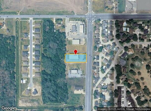
Property Record
2321 N Stuart Place Rd, Harlingen, TX 78552

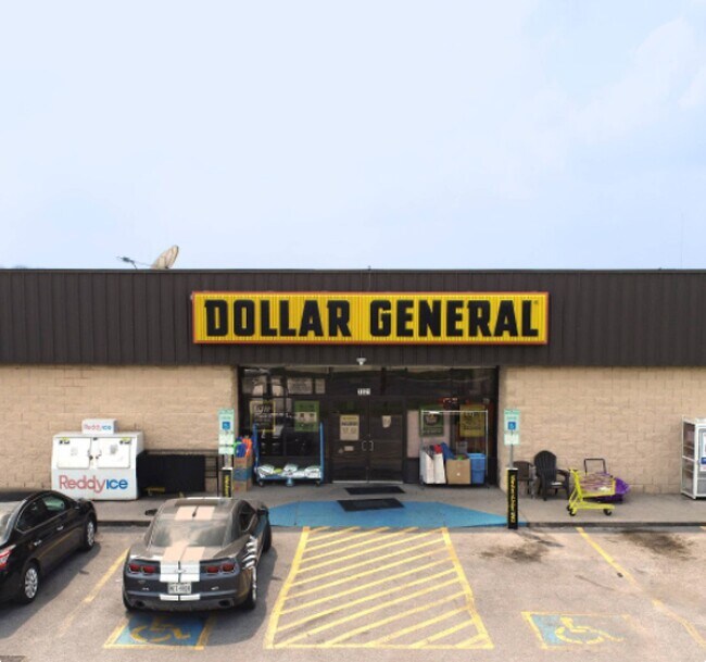
This Property Is For Sale
NEARBY LISTINGS FOR SALE OR LEASE
Property Detail
2321 N Stuart Place Rd
Brownsville-Harlingen, TX
North Star Business Center Subd
988081-0010-005000
NORTH STAR BUSINESS CENTER SUBD LOT 5 BLK 1 C1-2418-A
Commercialnec
Cameron
X
Texas
48061C0250F
5
2024
0.78 AC
2025
Outlying Cameron County
010304
Brownsville/Harlingen
9,217 SF
DEMOGRAPHICS near 2321 N Stuart Place Rd
1 Mile
3 Mile
5 Mile
2024 Total Population
4,990
28,950
75,113
2029 Population
5,041
29,616
76,768
Pop Growth 2024-2029
+ 1.02%
+ 2.30%
+ 2.20%
Average Age
39
38
37
2024 Total Households
1,794
9,707
25,261
HH Growth 2024-2029
+ 1.11%
+ 2.33%
+ 2.24%
Median Household Inc
$69,970
$60,406
$51,685
Avg Household Size
2.80
2.90
2.90
2024 Avg HH Vehicles
2.00
2.00
2.00
Median Home Value
$178,630
$123,833
$101,458
Median Year Built
1991
1993
1987
Nearby Places
Map Layers
Map Styles
 Street
 Aerial
- Restaurants
- Banks
- Shops
- Fitness
- Groceries
PUBLIC TRANSPORTATION
AIRPORT
Valley International
DRIVE
WALK
Distance
Valley International
26 min
14.3 mi
Brownsville/South Padre Island International
DRIVE
WALK
Distance
Brownsville/South Padre Island International
43 min
32.3 mi
McAllen International
DRIVE
WALK
Distance
McAllen International
42 min
34.0 mi
Freight Ports
Port of Brownsville
DRIVE
WALK
Distance
Port of Brownsville
36 min
30.0 mi
Nearby Properties
Address
Land Use
TOTAL SIZE
Lot Size
Zoning
Address
Land Use
TOTAL SIZE
Lot Size
Zoning
246,234 SF
16.40 AC
Address
Land Use
TOTAL SIZE
Lot Size
Zoning
74,848 SF
2.30 AC
Address
Land Use
TOTAL SIZE
Lot Size
Zoning
41,182 SF
34.14 AC
M-R
Address
Land Use
TOTAL SIZE
Lot Size
Zoning
152,724 SF
17.78 AC
Address
Land Use
TOTAL SIZE
Lot Size
Zoning
63,450 SF
2.88 AC
Address
Land Use
TOTAL SIZE
Lot Size
Zoning
13,924 SF
31.33 AC
C
Address
Land Use
TOTAL SIZE
Lot Size
Zoning
41,370 SF
3.40 AC
C
Address
Land Use
TOTAL SIZE
Lot Size
Zoning
51,748 SF
10 AC
Address
Land Use
TOTAL SIZE
Lot Size
Zoning
81,569 SF
36.61 AC
Address
Land Use
TOTAL SIZE
Lot Size
Zoning
91,630 SF
11.17 AC
Address
Land Use
TOTAL SIZE
Lot Size
Zoning
89,508 SF
9.90 AC
Address
Land Use
TOTAL SIZE
Lot Size
Zoning
47,539 SF
8.77 AC
C
Address
Land Use
TOTAL SIZE
Lot Size
Zoning
134,367 SF
14.42 AC
Address
Land Use
TOTAL SIZE
Lot Size
Zoning
68,826 SF
6.27 AC
Address
Land Use
TOTAL SIZE
Lot Size
Zoning
116,913 SF
8.44 AC
C
Address
Land Use
TOTAL SIZE
Lot Size
Zoning
77,077 SF
5.20 AC
Address
Land Use
TOTAL SIZE
Lot Size
Zoning
50,659 SF
6.43 AC
Address
Land Use
TOTAL SIZE
Lot Size
Zoning
20.64 AC
C
Address
Land Use
TOTAL SIZE
Lot Size
Zoning
18,016 SF
1.70 AC
Address
Land Use
TOTAL SIZE
Lot Size
Zoning
60,050 SF
1.98 AC
Address
Land Use
TOTAL SIZE
Lot Size
Zoning
47,388 SF
11.64 AC
Address
Land Use
TOTAL SIZE
Lot Size
Zoning
17,925 SF
6.34 AC
Address
Land Use
TOTAL SIZE
Lot Size
Zoning
144,000 SF
7.05 AC
Address
Land Use
TOTAL SIZE
Lot Size
Zoning
43,715 SF
8 AC
Address
Land Use
TOTAL SIZE
Lot Size
Zoning
82,320 SF
5.79 AC
Address
Land Use
TOTAL SIZE
Lot Size
Zoning
70,941 SF
3.68 AC
C
Address
Land Use
TOTAL SIZE
Lot Size
Zoning
26,300 SF
3.82 AC
Address
Land Use
TOTAL SIZE
Lot Size
Zoning
194,090 SF
13.17 AC
C
Address
Land Use
TOTAL SIZE
Lot Size
Zoning
1,216 SF
39.91 AC
A-R
Address
Land Use
TOTAL SIZE
Lot Size
Zoning
141,841 SF
9.99 AC
The World's #1 Commercial Real Estate Marketplace
Connect with us
© 2026 CoStar Group
The information above has been obtained from sources believed reliable. While we do not doubt its accuracy we have not verified it and make no guarantee, warranty or representation about it. It is your responsibility to independently confirm its accuracy and completeness. Any projections, opinions, assumptions, or estimates used are for example only and do not represent the current or future performance of the property. The value of this transaction to you depends on tax and other factors which should be evaluated by your tax, financial, and legal advisors. You and your advisors should conduct a careful, independent investigation of the property to determine to your satisfaction the suitability of the property for your needs.