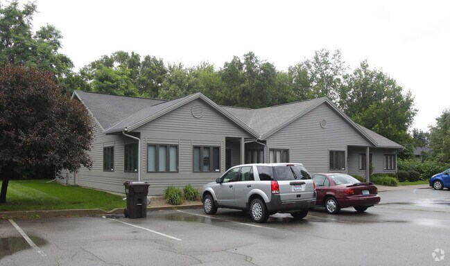
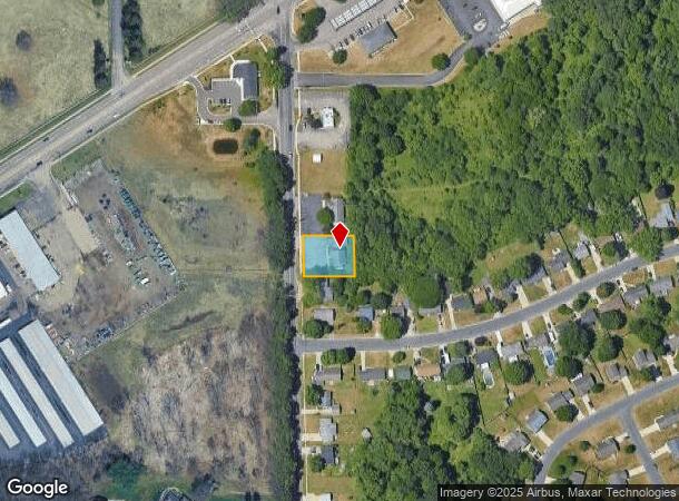
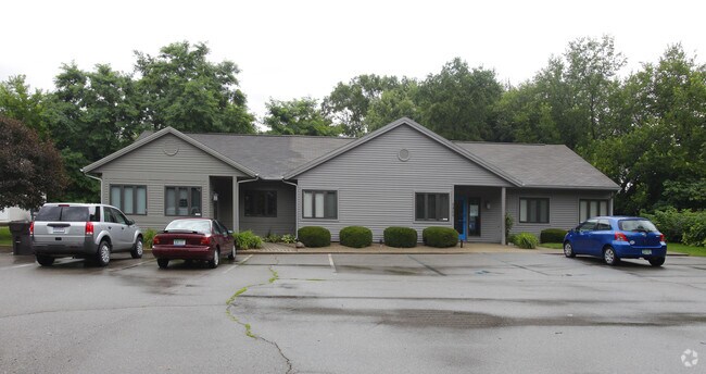
Property Record
2322 Nazareth Rd, Kalamazoo, MI 49048
NEARBY LISTINGS FOR SALE OR LEASE
Property Detail
2322 Nazareth Rd
Kalamazoo-Portage, MI
Gregory Park
06-12-280-182
2854540 3906 12 280 182 GREGORY PARK LOT 18 & S 37.5 FT OF LOT 19
Commercialnec
Kalamazoo
X
Michigan
26077C0185E
18-19
2024
0.33 AC
2025
NE Kalamazoo County
005502
West Michigan
2,812 SF
DEMOGRAPHICS near 2322 Nazareth Rd
1 Mile
3 Mile
5 Mile
2024 Total Population
6,633
38,474
92,927
2029 Population
6,579
38,534
92,956
Pop Growth 2024-2029
(0.81%)
+ 0.16%
+ 0.03%
Average Age
38
37
36
2024 Total Households
2,827
15,804
37,171
HH Growth 2024-2029
(0.85%)
+ 0.13%
+ 0.02%
Median Household Inc
$44,316
$49,692
$51,629
Avg Household Size
2.30
2.30
2.30
2024 Avg HH Vehicles
2.00
2.00
2.00
Median Home Value
$127,032
$137,642
$151,745
Median Year Built
1959
1959
1957
Nearby Places
Map Layers
Map Styles
 Street
 Aerial
- Restaurants
- Banks
- Shops
- Fitness
- Groceries
PUBLIC TRANSPORTATION
COMMUTER RAIL
DRIVE
WALK
Distance
6 min
3.3 mi
AIRPORT
Kalamazoo/Battle Creek International
DRIVE
WALK
Distance
Kalamazoo/Battle Creek International
18 min
6.9 mi
SALE & LEASE HISTORY
LISTING DATE
SALE/LEASE

Sep 24, 2016
For Sale
Nearby Properties
Address
Land Use
TOTAL SIZE
Lot Size
Zoning
Address
Land Use
TOTAL SIZE
Lot Size
Zoning
632,218 SF
10.84 AC
M-1
Address
Land Use
TOTAL SIZE
Lot Size
Zoning
429,500 SF
2 AC
CCBD
Address
Land Use
TOTAL SIZE
Lot Size
Zoning
877,422 SF
38.18 AC
M-2
Address
Land Use
TOTAL SIZE
Lot Size
Zoning
20.94 AC
Address
Land Use
TOTAL SIZE
Lot Size
Zoning
110,686 SF
9.45 AC
CCBD
Address
Land Use
TOTAL SIZE
Lot Size
Zoning
390,900 SF
14 AC
I-M IND
Address
Land Use
TOTAL SIZE
Lot Size
Zoning
275,595 SF
0.65 AC
CCBD
Address
Land Use
TOTAL SIZE
Lot Size
Zoning
50,826 SF
0.79 AC
CCBD
Address
Land Use
TOTAL SIZE
Lot Size
Zoning
185,107 SF
25.12 AC
RM
Address
Land Use
TOTAL SIZE
Lot Size
Zoning
196,221 SF
26.26 AC
RM
Address
Land Use
TOTAL SIZE
Lot Size
Zoning
185,092 SF
26.86 AC
RM
Address
Land Use
TOTAL SIZE
Lot Size
Zoning
12.58 AC
Address
Land Use
TOTAL SIZE
Lot Size
Zoning
274,412 SF
12.10 AC
RM-1
Address
Land Use
TOTAL SIZE
Lot Size
Zoning
226,051 SF
44.98 AC
B-2
Address
Land Use
TOTAL SIZE
Lot Size
Zoning
99,092 SF
1.45 AC
CCBD
Address
Land Use
TOTAL SIZE
Lot Size
Zoning
217,600 SF
21.30 AC
N/A
Address
Land Use
TOTAL SIZE
Lot Size
Zoning
133,600 SF
15.08 AC
B-1
Address
Land Use
TOTAL SIZE
Lot Size
Zoning
193,194 SF
23.96 AC
B-3
Address
Land Use
TOTAL SIZE
Lot Size
Zoning
99,017 SF
9.42 AC
RM
Address
Land Use
TOTAL SIZE
Lot Size
Zoning
185,528 SF
17.20 AC
R5
Address
Land Use
TOTAL SIZE
Lot Size
Zoning
129,780 SF
0.78 AC
CCBD
Address
Land Use
TOTAL SIZE
Lot Size
Zoning
98,360 SF
13.58 AC
R4
Address
Land Use
TOTAL SIZE
Lot Size
Zoning
143,760 SF
10.25 AC
M-2
Address
Land Use
TOTAL SIZE
Lot Size
Zoning
118,104 SF
10.40 AC
R4
Address
Land Use
TOTAL SIZE
Lot Size
Zoning
9.65 AC
RM-36
Address
Land Use
TOTAL SIZE
Lot Size
Zoning
49,216 SF
2.90 AC
RM-2
Address
Land Use
TOTAL SIZE
Lot Size
Zoning
275,595 SF
0.65 AC
CCBD
Address
Land Use
TOTAL SIZE
Lot Size
Zoning
1.72 AC
CMU
Address
Land Use
TOTAL SIZE
Lot Size
Zoning
673,310 SF
29.33 AC
A-H
Address
Land Use
TOTAL SIZE
Lot Size
Zoning
8,214 SF
2.39 AC
C-3 GEN
The World's #1 Commercial Real Estate Marketplace
Connect with us
© 2025 CoStar Group
The information above has been obtained from sources believed reliable. While we do not doubt its accuracy we have not verified it and make no guarantee, warranty or representation about it. It is your responsibility to independently confirm its accuracy and completeness. Any projections, opinions, assumptions, or estimates used are for example only and do not represent the current or future performance of the property. The value of this transaction to you depends on tax and other factors which should be evaluated by your tax, financial, and legal advisors. You and your advisors should conduct a careful, independent investigation of the property to determine to your satisfaction the suitability of the property for your needs.