Property Record
23221 Aldine Westfield Rd, Spring, TX 77373
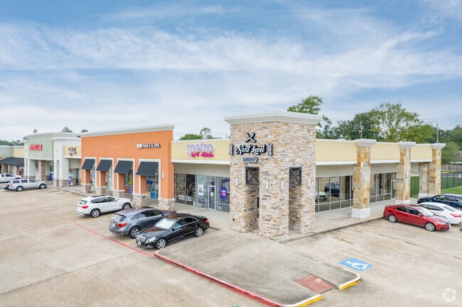
Property Detail
23221 Aldine Westfield Rd
1167280000004
RES B BROOKSHIRE PLAZA SEC 1
Regionalshoppingcenterormallwithanchorstore
HARRIS
AE The base floodplain where base flood elevations are provided. AE Zones are now used on new format FIRMs instead of A1-A30 Zones.
Texas
2024
8.93 AC
2025
Spring Creek
241201
Houston
104,562 SF
Houston-Pasadena-The Woodlands, TX
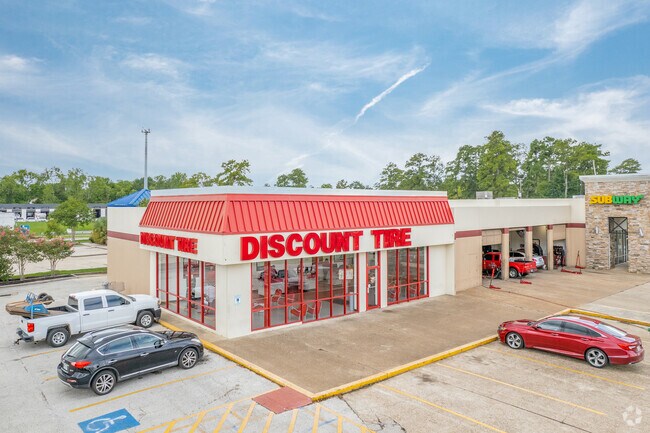
NEARBY LISTINGS FOR SALE OR LEASE
DEMOGRAPHICS near 23221 Aldine Westfield Rd
1 mile
3 mile
5 mile
2025 Total Population
17,249
89,055
216,403
2030 Population
18,509
96,194
235,343
Pop Growth 2025-2030
+ 7.30%
+ 8.02%
+ 8.75%
Average Age
36
36
35
2025 Total Households
5,869
29,814
73,684
HH Growth 2025-2030
+ 7.62%
+ 8.19%
+ 8.91%
Median Household Inc
$80,324
$81,789
$83,374
Avg Household Size
2.90
2.90
2.90
2025 Avg HH Vehicles
2.00
2.00
2.00
Median Home Value
$206,254
$246,345
$268,218
Median Year Built
1988
1997
2001
Nearby Places
Map Layers
Map Styles
 Street
 Aerial
Layers
 Traffic
 Biking
Places
Listings with unknown addresses are not visible on the map
- Restaurants
- Banks
- Shops
- Fitness
- Groceries
PUBLIC TRANSPORTATION
AIRPORT
George Bush Intcntl/Houston
Drive
Walk
Distance
George Bush Intcntl/Houston
19 min
11.0 mi
William P Hobby
Drive
Walk
Distance
William P Hobby
55 min
35.0 mi
Freight Ports
Port of Houston
Drive
Walk
Distance
Port of Houston
43 min
28.9 mi
SALE & LEASE HISTORY
LISTING DATE
SALE/LEASE

Apr 06, 2017
For Lease
Nearby Properties
Address
Land Use
TOTAL SIZE
Lot Size
Zoning
Address
Land Use
TOTAL SIZE
Lot Size
Zoning
409,480 SF
27.32 AC
Address
Land Use
TOTAL SIZE
Lot Size
Zoning
288,721 SF
Address
Land Use
TOTAL SIZE
Lot Size
Zoning
350,423 SF
122.83 AC
Address
Land Use
TOTAL SIZE
Lot Size
Zoning
280,283 SF
16.56 AC
Address
Land Use
TOTAL SIZE
Lot Size
Zoning
271,432 SF
35.81 AC
Address
Land Use
TOTAL SIZE
Lot Size
Zoning
136,748 SF
30.29 AC
Address
Land Use
TOTAL SIZE
Lot Size
Zoning
291,504 SF
17.17 AC
Address
Land Use
TOTAL SIZE
Lot Size
Zoning
259,000 SF
14.73 AC
Address
Land Use
TOTAL SIZE
Lot Size
Zoning
259,000 SF
15.73 AC
Address
Land Use
TOTAL SIZE
Lot Size
Zoning
158,081 SF
23.46 AC
Address
Land Use
TOTAL SIZE
Lot Size
Zoning
244,846 SF
10.03 AC
Address
Land Use
TOTAL SIZE
Lot Size
Zoning
134,368 SF
7.10 AC
Address
Land Use
TOTAL SIZE
Lot Size
Zoning
204,870 SF
13.40 AC
Address
Land Use
TOTAL SIZE
Lot Size
Zoning
223,231 SF
21.23 AC
Address
Land Use
TOTAL SIZE
Lot Size
Zoning
238,835 SF
9.98 AC
Address
Land Use
TOTAL SIZE
Lot Size
Zoning
249,296 SF
10.10 AC
Address
Land Use
TOTAL SIZE
Lot Size
Zoning
175,495 SF
8.92 AC
Address
Land Use
TOTAL SIZE
Lot Size
Zoning
267,250 SF
11.83 AC
Address
Land Use
TOTAL SIZE
Lot Size
Zoning
127,260 SF
14 AC
Address
Land Use
TOTAL SIZE
Lot Size
Zoning
92,975 SF
10.66 AC
Address
Land Use
TOTAL SIZE
Lot Size
Zoning
174,800 SF
14.43 AC
Address
Land Use
TOTAL SIZE
Lot Size
Zoning
59,589 SF
9.74 AC
Address
Land Use
TOTAL SIZE
Lot Size
Zoning
222,382 SF
10.44 AC
Address
Land Use
TOTAL SIZE
Lot Size
Zoning
230,633 SF
10.75 AC
Address
Land Use
TOTAL SIZE
Lot Size
Zoning
152,898 SF
17 AC
Address
Land Use
TOTAL SIZE
Lot Size
Zoning
135,628 SF
15.04 AC
Address
Land Use
TOTAL SIZE
Lot Size
Zoning
216,390 SF
8.42 AC
Address
Land Use
TOTAL SIZE
Lot Size
Zoning
281,563 SF
19.98 AC
Address
Land Use
TOTAL SIZE
Lot Size
Zoning
89,044 SF
13.17 AC
Address
Land Use
TOTAL SIZE
Lot Size
Zoning
64,010 SF
5.90 AC
The World's #1 Commercial Real Estate Marketplace
Connect with us
© 2026 CoStar Group
The information above has been obtained from sources believed reliable. While we do not doubt its accuracy we have not verified it and make no guarantee, warranty or representation about it. It is your responsibility to independently confirm its accuracy and completeness. Any projections, opinions, assumptions, or estimates used are for example only and do not represent the current or future performance of the property. The value of this transaction to you depends on tax and other factors which should be evaluated by your tax, financial, and legal advisors. You and your advisors should conduct a careful, independent investigation of the property to determine to your satisfaction the suitability of the property for your needs.