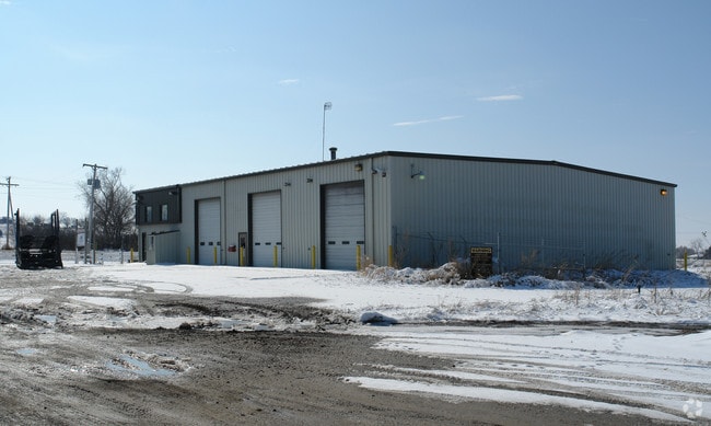
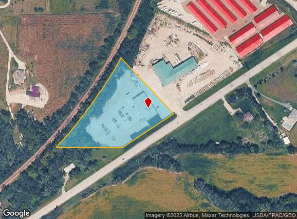
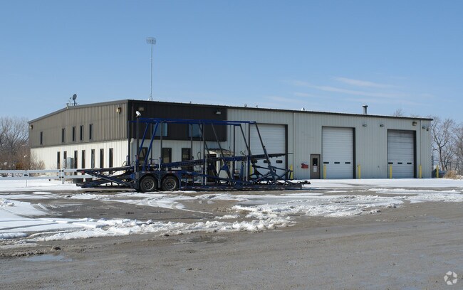
Property Record
23232 Highway 6, Gretna, NE 68028
NEARBY LISTINGS FOR SALE OR LEASE
Property Detail
23232 Highway 6
Omaha-Council Bluffs, NE-IA
Double S Development
011575959
LOT 1 DOUBLE S DEVELOPMENT (4.66 AC)
Industrialgeneral
Sarpy
X
Nebraska
31025C0050D
1
2024
1.10 AC
2025
Sarpy West
010701
Omaha/Council Bluffs
4,800 SF
DEMOGRAPHICS near 23232 Highway 6
1 Mile
3 Mile
5 Mile
2024 Total Population
127
2,196
14,213
2029 Population
134
2,345
15,470
Pop Growth 2024-2029
+ 5.51%
+ 6.79%
+ 8.84%
Average Age
40
39
37
2024 Total Households
43
727
4,905
HH Growth 2024-2029
+ 4.65%
+ 7.02%
+ 8.95%
Median Household Inc
$123,437
$136,005
$115,636
Avg Household Size
3.00
3.00
2.90
2024 Avg HH Vehicles
3.00
3.00
3.00
Median Home Value
$456,249
$461,864
$334,821
Median Year Built
1992
1995
2001
Nearby Places
Map Layers
Map Styles
 Street
 Aerial
- Restaurants
- Banks
- Shops
- Fitness
- Groceries
PUBLIC TRANSPORTATION
AIRPORT
Eppley Airfield
DRIVE
WALK
Distance
Eppley Airfield
40 min
28.8 mi
Lincoln
DRIVE
WALK
Distance
Lincoln
41 min
33.6 mi
Nearby Properties
Address
Land Use
TOTAL SIZE
Lot Size
Zoning
Address
Land Use
TOTAL SIZE
Lot Size
Zoning
46,338 SF
25.95 AC
Address
Land Use
TOTAL SIZE
Lot Size
Zoning
30.87 AC
Address
Land Use
TOTAL SIZE
Lot Size
Zoning
1,288 SF
157.59 AC
AG
Address
Land Use
TOTAL SIZE
Lot Size
Zoning
15.85 AC
Address
Land Use
TOTAL SIZE
Lot Size
Zoning
37,589 SF
6.76 AC
Address
Land Use
TOTAL SIZE
Lot Size
Zoning
6.78 AC
Address
Land Use
TOTAL SIZE
Lot Size
Zoning
17,250 SF
10.21 AC
Address
Land Use
TOTAL SIZE
Lot Size
Zoning
1.65 AC
I1
Address
Land Use
TOTAL SIZE
Lot Size
Zoning
Address
Land Use
TOTAL SIZE
Lot Size
Zoning
5.33 AC
Address
Land Use
TOTAL SIZE
Lot Size
Zoning
32,763 SF
3 AC
Address
Land Use
TOTAL SIZE
Lot Size
Zoning
41,075 SF
1.04 AC
Address
Land Use
TOTAL SIZE
Lot Size
Zoning
66,758 SF
10.55 AC
I1
Address
Land Use
TOTAL SIZE
Lot Size
Zoning
11,836 SF
6.12 AC
Address
Land Use
TOTAL SIZE
Lot Size
Zoning
20,400 SF
3.14 AC
Address
Land Use
TOTAL SIZE
Lot Size
Zoning
15,595 SF
12.24 AC
HC
Address
Land Use
TOTAL SIZE
Lot Size
Zoning
487 SF
31.22 AC
Address
Land Use
TOTAL SIZE
Lot Size
Zoning
10,500 SF
3.44 AC
I1
Address
Land Use
TOTAL SIZE
Lot Size
Zoning
0.96 AC
Address
Land Use
TOTAL SIZE
Lot Size
Zoning
4,000 SF
284.99 AC
AGFP
Address
Land Use
TOTAL SIZE
Lot Size
Zoning
35.39 AC
GC
Address
Land Use
TOTAL SIZE
Lot Size
Zoning
27,244 SF
1.97 AC
Address
Land Use
TOTAL SIZE
Lot Size
Zoning
20,000 SF
1.72 AC
Address
Land Use
TOTAL SIZE
Lot Size
Zoning
10,451 SF
2.07 AC
Address
Land Use
TOTAL SIZE
Lot Size
Zoning
22,225 SF
2.99 AC
Address
Land Use
TOTAL SIZE
Lot Size
Zoning
9,486 SF
1.38 AC
Address
Land Use
TOTAL SIZE
Lot Size
Zoning
314.90 AC
AGFP
Address
Land Use
TOTAL SIZE
Lot Size
Zoning
17,680 SF
1.52 AC
Address
Land Use
TOTAL SIZE
Lot Size
Zoning
0.40 AC
Address
Land Use
TOTAL SIZE
Lot Size
Zoning
18,000 SF
0.20 AC
I1
The World's #1 Commercial Real Estate Marketplace
Connect with us
© 2026 CoStar Group
The information above has been obtained from sources believed reliable. While we do not doubt its accuracy we have not verified it and make no guarantee, warranty or representation about it. It is your responsibility to independently confirm its accuracy and completeness. Any projections, opinions, assumptions, or estimates used are for example only and do not represent the current or future performance of the property. The value of this transaction to you depends on tax and other factors which should be evaluated by your tax, financial, and legal advisors. You and your advisors should conduct a careful, independent investigation of the property to determine to your satisfaction the suitability of the property for your needs.