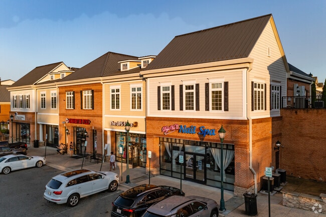
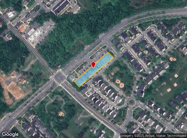
Property Record
23237 Stringtown Rd, Clarksburg, MD 20871


NEARBY LISTINGS FOR SALE OR LEASE
Property Detail
23237 Stringtown Rd
02-03480008
Clarksburg Highlands Codm
Storesoffices
UN 23237 CLARKSBURG HIGHLANDS CODM PH 1
X
Montgomery
24031C0160D
Maryland
2024
I-270 Corridor North
2025
Washington, DC
700316
Washington-Arlington-Alexandria, DC-VA-MD-WV
1,539 SF
DEMOGRAPHICS near 23237 Stringtown Rd
1 mile
3 mile
5 mile
2024 Total Population
9,284
38,890
106,675
2029 Population
9,180
38,324
105,230
Pop Growth 2024-2029
(1.12%)
(1.46%)
(1.35%)
Average Age
36
37
38
2024 Total Households
2,816
12,130
35,733
HH Growth 2024-2029
(1.28%)
(1.65%)
(1.51%)
Median Household Inc
$135,918
$143,171
$117,227
Avg Household Size
3.30
3.10
2.90
2024 Avg HH Vehicles
2.00
2.00
2.00
Median Home Value
$549,849
$615,167
$459,575
Median Year Built
2005
2004
1991
Nearby Places
Map Layers
Map Styles
 Street
 Aerial
Transit
 Traffic
 Biking
Places
Listings with unknown addresses are not visible on the map
- Restaurants
- Banks
- Shops
- Fitness
- Groceries
SALE & LEASE HISTORY
LISTING DATE
SALE/LEASE

Jan 14, 2021
For Sale
Feb 25, 2019
For Lease
Feb 23, 2018
For Lease
Nearby Properties
Address
Land Use
TOTAL SIZE
Lot Size
Zoning
Address
Land Use
TOTAL SIZE
Lot Size
Zoning
514,960 SF
32.57 AC
R30
Address
Land Use
TOTAL SIZE
Lot Size
Zoning
437,229 SF
50.58 AC
CRT0.
Address
Land Use
TOTAL SIZE
Lot Size
Zoning
6,140 SF
103.05 AC
EOF07
Address
Land Use
TOTAL SIZE
Lot Size
Zoning
309,216 SF
61.50 AC
R200
Address
Land Use
TOTAL SIZE
Lot Size
Zoning
211,475 SF
21.01 AC
CR2.0
Address
Land Use
TOTAL SIZE
Lot Size
Zoning
45,126 SF
19.19 AC
TS
Address
Land Use
TOTAL SIZE
Lot Size
Zoning
150,089 SF
22.37 AC
PD4
Address
Land Use
TOTAL SIZE
Lot Size
Zoning
233,346 SF
6.10 AC
R200
Address
Land Use
TOTAL SIZE
Lot Size
Zoning
97,000 SF
5.84 AC
CR0.7
Address
Land Use
TOTAL SIZE
Lot Size
Zoning
183,650 SF
5 AC
R200
Address
Land Use
TOTAL SIZE
Lot Size
Zoning
143,691 SF
5.12 AC
CRT0.
Address
Land Use
TOTAL SIZE
Lot Size
Zoning
102,734 SF
10.76 AC
CRT2.
Address
Land Use
TOTAL SIZE
Lot Size
Zoning
141,140 SF
4.53 AC
CRT0.
Address
Land Use
TOTAL SIZE
Lot Size
Zoning
109,424 SF
2.69 AC
CR0.7
Address
Land Use
TOTAL SIZE
Lot Size
Zoning
91,809 SF
9.79 AC
R200
Address
Land Use
TOTAL SIZE
Lot Size
Zoning
148,065 SF
23.29 AC
R200
Address
Land Use
TOTAL SIZE
Lot Size
Zoning
91,677 SF
9.61 AC
CRT0.
Address
Land Use
TOTAL SIZE
Lot Size
Zoning
110,054 SF
2.31 AC
CR0.7
Address
Land Use
TOTAL SIZE
Lot Size
Zoning
156,697 SF
2.89 AC
CR0.7
Address
Land Use
TOTAL SIZE
Lot Size
Zoning
88,042 SF
10.75 AC
R200
Address
Land Use
TOTAL SIZE
Lot Size
Zoning
136,782 SF
2.98 AC
PD4
Address
Land Use
TOTAL SIZE
Lot Size
Zoning
73,165 SF
2.89 AC
CRT07
Address
Land Use
TOTAL SIZE
Lot Size
Zoning
94,600 SF
11.12 AC
EOF07
Address
Land Use
TOTAL SIZE
Lot Size
Zoning
165,298 SF
15.32 AC
CRT07
Address
Land Use
TOTAL SIZE
Lot Size
Zoning
83,952 SF
9.23 AC
PD4
Address
Land Use
TOTAL SIZE
Lot Size
Zoning
84,800 SF
6.67 AC
EOF07
Address
Land Use
TOTAL SIZE
Lot Size
Zoning
1,872 SF
92.54 AC
RE1
Address
Land Use
TOTAL SIZE
Lot Size
Zoning
61,836 SF
9.29 AC
R200
Address
Land Use
TOTAL SIZE
Lot Size
Zoning
103,198 SF
5.62 AC
CR0.7
Address
Land Use
TOTAL SIZE
Lot Size
Zoning
2,424 SF
132.29 AC
RE2
The World's #1 Commercial Real Estate Marketplace
Connect with us
© 2026 CoStar Group
The information above has been obtained from sources believed reliable. While we do not doubt its accuracy we have not verified it and make no guarantee, warranty or representation about it. It is your responsibility to independently confirm its accuracy and completeness. Any projections, opinions, assumptions, or estimates used are for example only and do not represent the current or future performance of the property. The value of this transaction to you depends on tax and other factors which should be evaluated by your tax, financial, and legal advisors. You and your advisors should conduct a careful, independent investigation of the property to determine to your satisfaction the suitability of the property for your needs.