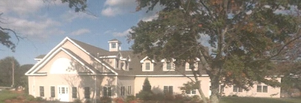
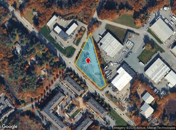
Property Record
2324 Turnpike St, North Andover, MA 01845
NEARBY LISTINGS FOR SALE OR LEASE
-
-
View all North Andover listings for sale on LoopNet.com
Property Detail
2324 Turnpike St
NAND-000108A-000008
Plan 6649
Daycare
Essex
X
Massachusetts
25009C0381G
1.52 AC
2025
Lawrence/Andover
2025
Boston
253204
Boston-Cambridge-Newton, MA-NH
13,039 SF
DEMOGRAPHICS near 2324 Turnpike St
1 Mile
3 Mile
5 Mile
2024 Total Population
1,585
13,947
65,947
2029 Population
1,577
13,902
65,748
Pop Growth 2024-2029
(0.50%)
(0.32%)
(0.30%)
Average Age
41
40
41
2024 Total Households
555
4,655
22,214
HH Growth 2024-2029
(0.36%)
(0.43%)
(0.36%)
Median Household Inc
$156,649
$178,897
$155,339
Avg Household Size
2.70
3.00
2.80
2024 Avg HH Vehicles
2.00
2.00
2.00
Median Home Value
$687,013
$735,813
$732,999
Median Year Built
2002
1984
1977
Nearby Places
Map Layers
Map Styles
 Street
 Aerial
- Restaurants
- Banks
- Shops
- Fitness
- Groceries
PUBLIC TRANSPORTATION
COMMUTER RAIL
Andover (Haverhill Line - Massachusetts Bay Transportation Authority Commuter Rail (Purple Line))
DRIVE
WALK
Distance
Andover (Haverhill Line - Massachusetts Bay Transportation Authority Commuter Rail (Purple Line))
13 min
6.6 mi
Lawrence (Haverhill Line - Massachusetts Bay Transportation Authority Commuter Rail (Purple Line))
DRIVE
WALK
Distance
Lawrence (Haverhill Line - Massachusetts Bay Transportation Authority Commuter Rail (Purple Line))
16 min
7.7 mi
AIRPORT
General Edward Lawrence Logan International
DRIVE
WALK
Distance
General Edward Lawrence Logan International
40 min
22.5 mi
Manchester Boston Regional
DRIVE
WALK
Distance
Manchester Boston Regional
57 min
36.7 mi
Portsmouth International at Pease
DRIVE
WALK
Distance
Portsmouth International at Pease
59 min
41.3 mi
Nearby Properties
Address
Land Use
TOTAL SIZE
Lot Size
Zoning
Address
Land Use
TOTAL SIZE
Lot Size
Zoning
26.09 AC
R2
Address
Land Use
TOTAL SIZE
Lot Size
Zoning
169,008 SF
33.35 AC
VC
Address
Land Use
TOTAL SIZE
Lot Size
Zoning
36,156 SF
754.25 AC
R1A
Address
Land Use
TOTAL SIZE
Lot Size
Zoning
81,746 SF
10.50 AC
R1A
Address
Land Use
TOTAL SIZE
Lot Size
Zoning
683.90 AC
SRC
Address
Land Use
TOTAL SIZE
Lot Size
Zoning
Address
Land Use
TOTAL SIZE
Lot Size
Zoning
94,999 SF
B1A
Address
Land Use
TOTAL SIZE
Lot Size
Zoning
1,246.80 AC
R2
Address
Land Use
TOTAL SIZE
Lot Size
Zoning
66,660 SF
B1A
Address
Land Use
TOTAL SIZE
Lot Size
Zoning
58,204 SF
15.35 AC
RA
Address
Land Use
TOTAL SIZE
Lot Size
Zoning
56,088 SF
0.18 AC
VR
Address
Land Use
TOTAL SIZE
Lot Size
Zoning
16,114 SF
1 AC
B
Address
Land Use
TOTAL SIZE
Lot Size
Zoning
66,000 SF
3.05 AC
I2
Address
Land Use
TOTAL SIZE
Lot Size
Zoning
86.50 AC
SRC
Address
Land Use
TOTAL SIZE
Lot Size
Zoning
8.66 AC
R-2
Address
Land Use
TOTAL SIZE
Lot Size
Zoning
44,227 SF
M1
Address
Land Use
TOTAL SIZE
Lot Size
Zoning
19,803 SF
2.03 AC
GB
Address
Land Use
TOTAL SIZE
Lot Size
Zoning
1,089 SF
3.52 AC
B2
Address
Land Use
TOTAL SIZE
Lot Size
Zoning
34,814 SF
6.32 AC
M1
Address
Land Use
TOTAL SIZE
Lot Size
Zoning
1.55 AC
B
Address
Land Use
TOTAL SIZE
Lot Size
Zoning
35,434 SF
8.07 AC
I1
Address
Land Use
TOTAL SIZE
Lot Size
Zoning
14,700 SF
M1
Address
Land Use
TOTAL SIZE
Lot Size
Zoning
0.94 AC
B
Address
Land Use
TOTAL SIZE
Lot Size
Zoning
112 AC
R1B
Address
Land Use
TOTAL SIZE
Lot Size
Zoning
15,000 SF
B1A
Address
Land Use
TOTAL SIZE
Lot Size
Zoning
7.41 AC
M1
Address
Land Use
TOTAL SIZE
Lot Size
Zoning
41.80 AC
R2
Address
Land Use
TOTAL SIZE
Lot Size
Zoning
30,520 SF
3.12 AC
I1
Address
Land Use
TOTAL SIZE
Lot Size
Zoning
525.99 AC
The World's #1 Commercial Real Estate Marketplace
Connect with us
© 2026 CoStar Group
The information above has been obtained from sources believed reliable. While we do not doubt its accuracy we have not verified it and make no guarantee, warranty or representation about it. It is your responsibility to independently confirm its accuracy and completeness. Any projections, opinions, assumptions, or estimates used are for example only and do not represent the current or future performance of the property. The value of this transaction to you depends on tax and other factors which should be evaluated by your tax, financial, and legal advisors. You and your advisors should conduct a careful, independent investigation of the property to determine to your satisfaction the suitability of the property for your needs.