Property Record
2325 W Norton Rd, Springfield, MO 65803
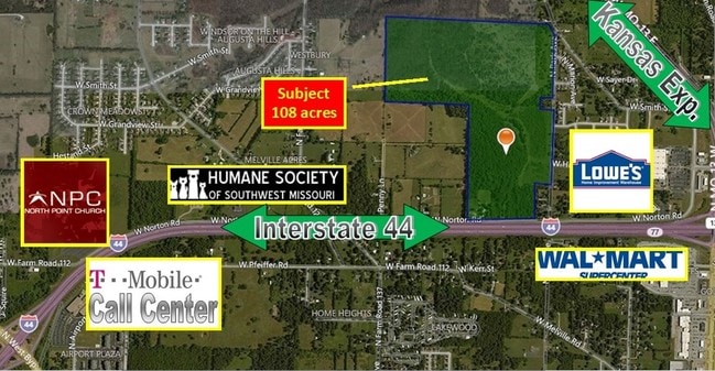


This Property Is For Sale
Property Detail
2325 W Norton Rd
Springfield, MO
42.13A M/L E1/2 LOT 2 NW1/4 (EX E 200 FT) & E1/2 E1/2 LOT 1 NW1/4 (EX E 200 FT)& E 264 FT W1/2 E1/2 LOT 1 NW1/4 (EX HWY)
13-03-227-027
GREENE
Agriculturalland
Missouri
INC
1-2
B and X Area of moderate flood hazard, usually the area between the limits of the 100-year and 500-year floods.
42.13 AC
2025
Outlying Greene County
2025
Springfield
004303
NEARBY LISTINGS FOR SALE OR LEASE
DEMOGRAPHICS near 2325 W Norton Rd
1 mile
3 mile
5 mile
2025 Total Population
2,807
39,516
102,613
2030 Population
2,913
40,789
105,844
Pop Growth 2025-2030
+ 3.78%
+ 3.22%
+ 3.15%
Average Age
39
38
37
2025 Total Households
1,177
16,022
43,575
HH Growth 2025-2030
+ 3.91%
+ 3.41%
+ 3.46%
Median Household Inc
$59,575
$45,044
$44,650
Avg Household Size
2.30
2.30
2.10
2025 Avg HH Vehicles
2.00
2.00
2.00
Median Home Value
$209,170
$148,415
$158,326
Median Year Built
1999
1973
1976
Nearby Places
Map Layers
Map Styles
 Street
 Aerial
Layers
 Traffic
 Biking
Places
Listings with unknown addresses are not visible on the map
- Restaurants
- Banks
- Shops
- Fitness
- Groceries
PUBLIC TRANSPORTATION
AIRPORT
Springfield-Branson Ntl
Drive
Walk
Distance
Springfield-Branson Ntl
17 min
9.3 mi
Freight Ports
Tulsa Port of Inola
Drive
Walk
Distance
Tulsa Port of Inola
191 min
171.6 mi
Nearby Properties
Address
Land Use
TOTAL SIZE
Lot Size
Zoning
Address
Land Use
TOTAL SIZE
Lot Size
Zoning
23.75 AC
Address
Land Use
TOTAL SIZE
Lot Size
Zoning
234,926 SF
9.41 AC
INC
Address
Land Use
TOTAL SIZE
Lot Size
Zoning
186,125 SF
21.09 AC
INC
Address
Land Use
TOTAL SIZE
Lot Size
Zoning
2.92 AC
INC
Address
Land Use
TOTAL SIZE
Lot Size
Zoning
93,916 SF
7.91 AC
INC
Address
Land Use
TOTAL SIZE
Lot Size
Zoning
29.42 AC
INC
Address
Land Use
TOTAL SIZE
Lot Size
Zoning
136,629 SF
26.79 AC
INC
Address
Land Use
TOTAL SIZE
Lot Size
Zoning
10.76 AC
INC
Address
Land Use
TOTAL SIZE
Lot Size
Zoning
16.08 AC
Address
Land Use
TOTAL SIZE
Lot Size
Zoning
75.07 AC
INC
Address
Land Use
TOTAL SIZE
Lot Size
Zoning
Address
Land Use
TOTAL SIZE
Lot Size
Zoning
Address
Land Use
TOTAL SIZE
Lot Size
Zoning
Address
Land Use
TOTAL SIZE
Lot Size
Zoning
12.39 AC
Address
Land Use
TOTAL SIZE
Lot Size
Zoning
78,239 SF
10.01 AC
INC
Address
Land Use
TOTAL SIZE
Lot Size
Zoning
213,437 SF
1.58 AC
INC
Address
Land Use
TOTAL SIZE
Lot Size
Zoning
Address
Land Use
TOTAL SIZE
Lot Size
Zoning
77,160 SF
6.31 AC
INC
Address
Land Use
TOTAL SIZE
Lot Size
Zoning
55,568 SF
2.13 AC
INC
Address
Land Use
TOTAL SIZE
Lot Size
Zoning
504,804 SF
34.94 AC
INC
Address
Land Use
TOTAL SIZE
Lot Size
Zoning
51,320 SF
1.93 AC
INC.
Address
Land Use
TOTAL SIZE
Lot Size
Zoning
90,928 SF
5.36 AC
INC
Address
Land Use
TOTAL SIZE
Lot Size
Zoning
238,700 SF
14.05 AC
INC
Address
Land Use
TOTAL SIZE
Lot Size
Zoning
3,640 SF
22.50 AC
INC
Address
Land Use
TOTAL SIZE
Lot Size
Zoning
50,000 SF
7.30 AC
INC
Address
Land Use
TOTAL SIZE
Lot Size
Zoning
75,000 SF
5.69 AC
INC
Address
Land Use
TOTAL SIZE
Lot Size
Zoning
267,740 SF
26.80 AC
M-1
Address
Land Use
TOTAL SIZE
Lot Size
Zoning
10.60 AC
Address
Land Use
TOTAL SIZE
Lot Size
Zoning
75,938 SF
43.53 AC
INC
Address
Land Use
TOTAL SIZE
Lot Size
Zoning
27,871 SF
4.81 AC
INC
The World's #1 Commercial Real Estate Marketplace
Connect with us
© 2026 CoStar Group
The information above has been obtained from sources believed reliable. While we do not doubt its accuracy we have not verified it and make no guarantee, warranty or representation about it. It is your responsibility to independently confirm its accuracy and completeness. Any projections, opinions, assumptions, or estimates used are for example only and do not represent the current or future performance of the property. The value of this transaction to you depends on tax and other factors which should be evaluated by your tax, financial, and legal advisors. You and your advisors should conduct a careful, independent investigation of the property to determine to your satisfaction the suitability of the property for your needs.