Property Record
23264 Ih 10, Vidor, TX 77662


Save to a Folder
{{folder.Name}}
{{folder.ListingIds.length}} Properties
{{folder.ListingIds.length}} Property
Create a New Folder
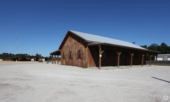
Property Detail
23264 Ih 10
000029-000121
29 ABST. 29 JAMES ARMSTRONG, TRACT 001, ACRES 5.57
Commercialnec
ORANGE
AE The base floodplain where base flood elevations are provided. AE Zones are now used on new format FIRMs instead of A1-A30 Zones.
Texas
2025
5.57 AC
2025
Orange County
021700
Beaumont/Port Arthur
3,120 SF
Beaumont-Port Arthur, TX
NEARBY LISTINGS FOR SALE OR LEASE
-
-
View all Vidor listings for sale on LoopNet.com
DEMOGRAPHICS near 23264 Ih 10
1 mile
3 mile
5 mile
2025 Total Population
252
7,628
44,763
2030 Population
256
7,880
45,630
Pop Growth 2025-2030
+ 1.59%
+ 3.30%
+ 1.94%
Average Age
43
40
38
2025 Total Households
111
2,938
16,848
HH Growth 2025-2030
+ 1.80%
+ 3.23%
+ 1.98%
Median Household Inc
$33,333
$57,491
$49,028
Avg Household Size
2.20
2.50
2.50
2025 Avg HH Vehicles
2.00
2.00
2.00
Median Home Value
$94,444
$118,979
$112,729
Median Year Built
1979
1978
1974
Nearby Places
Map Layers
Map Styles
 Street
 Aerial
Layers
 Traffic
 Biking
Places
Listings with unknown addresses are not visible on the map
- Restaurants
- Banks
- Shops
- Fitness
- Groceries
PUBLIC TRANSPORTATION
COMMUTER RAIL
Drive
Walk
Distance
12 min
6.7 mi
Freight Ports
Port Beaumont
Drive
Walk
Distance
Port Beaumont
9 min
4.4 mi
Nearby Properties
Address
Land Use
TOTAL SIZE
Lot Size
Zoning
Address
Land Use
TOTAL SIZE
Lot Size
Zoning
262,985 SF
18.80 AC
Address
Land Use
TOTAL SIZE
Lot Size
Zoning
187,028 SF
25.07 AC
Address
Land Use
TOTAL SIZE
Lot Size
Zoning
91,251 SF
14.74 AC
Address
Land Use
TOTAL SIZE
Lot Size
Zoning
27,344 SF
1.57 AC
Address
Land Use
TOTAL SIZE
Lot Size
Zoning
17,356 SF
2.01 AC
Address
Land Use
TOTAL SIZE
Lot Size
Zoning
16,000 SF
2.73 AC
Address
Land Use
TOTAL SIZE
Lot Size
Zoning
110,780 SF
9.32 AC
Address
Land Use
TOTAL SIZE
Lot Size
Zoning
62,892 SF
13.17 AC
Address
Land Use
TOTAL SIZE
Lot Size
Zoning
4,398 SF
0.97 AC
Address
Land Use
TOTAL SIZE
Lot Size
Zoning
53,212 SF
27.78 AC
Address
Land Use
TOTAL SIZE
Lot Size
Zoning
32.96 AC
Address
Land Use
TOTAL SIZE
Lot Size
Zoning
35,320 SF
2.87 AC
Address
Land Use
TOTAL SIZE
Lot Size
Zoning
14,510 SF
1.61 AC
Address
Land Use
TOTAL SIZE
Lot Size
Zoning
1,700 SF
190.22 AC
Address
Land Use
TOTAL SIZE
Lot Size
Zoning
23,700 SF
3.99 AC
Address
Land Use
TOTAL SIZE
Lot Size
Zoning
25,143 SF
1.41 AC
Address
Land Use
TOTAL SIZE
Lot Size
Zoning
19,356 SF
10.03 AC
Address
Land Use
TOTAL SIZE
Lot Size
Zoning
5,675 SF
1.27 AC
Address
Land Use
TOTAL SIZE
Lot Size
Zoning
14,400 SF
1.09 AC
Address
Land Use
TOTAL SIZE
Lot Size
Zoning
20,000 SF
3.45 AC
Address
Land Use
TOTAL SIZE
Lot Size
Zoning
11,626 SF
1.39 AC
Address
Land Use
TOTAL SIZE
Lot Size
Zoning
29,500 SF
3.60 AC
Address
Land Use
TOTAL SIZE
Lot Size
Zoning
10,840 SF
5.17 AC
Address
Land Use
TOTAL SIZE
Lot Size
Zoning
9,148 SF
22.07 AC
Address
Land Use
TOTAL SIZE
Lot Size
Zoning
22.83 AC
Address
Land Use
TOTAL SIZE
Lot Size
Zoning
8,530 SF
4.14 AC
Address
Land Use
TOTAL SIZE
Lot Size
Zoning
215.63 AC
Address
Land Use
TOTAL SIZE
Lot Size
Zoning
4,366 SF
0.95 AC
Address
Land Use
TOTAL SIZE
Lot Size
Zoning
6,252 SF
3.66 AC
Address
Land Use
TOTAL SIZE
Lot Size
Zoning
2.53 AC
The World's #1 Commercial Real Estate Marketplace
Connect with us
© 2026 CoStar Group
The information above has been obtained from sources believed reliable. While we do not doubt its accuracy we have not verified it and make no guarantee, warranty or representation about it. It is your responsibility to independently confirm its accuracy and completeness. Any projections, opinions, assumptions, or estimates used are for example only and do not represent the current or future performance of the property. The value of this transaction to you depends on tax and other factors which should be evaluated by your tax, financial, and legal advisors. You and your advisors should conduct a careful, independent investigation of the property to determine to your satisfaction the suitability of the property for your needs.