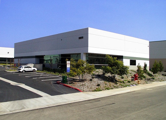
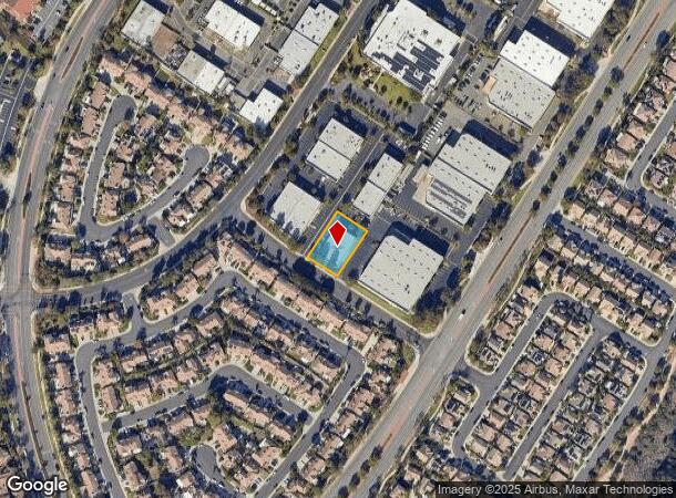
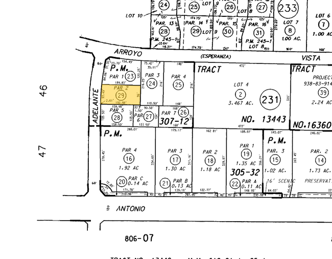
Property Record
23272 Arroyo Vis, Rancho Santa Margarita, CA 92688
Current Lease Availabilities
NEARBY LISTINGS FOR SALE OR LEASE
Property Detail
23272 Arroyo Vis
805-231-28
P BK 307 PG 12 PAR 5
Industrialgeneral
Orange
X
California
06073C0025F
0.38 AC
2024
RSM/Coto De Cazo/Ladera Ranch/RMV
2025
Orange County (California)
032053
Anaheim-Santa Ana-Irvine, CA
DEMOGRAPHICS near 23272 Arroyo Vis
1 Mile
3 Mile
5 Mile
2024 Total Population
8,768
94,787
211,488
2029 Population
8,608
92,966
207,710
Pop Growth 2024-2029
(1.82%)
(1.92%)
(1.79%)
Average Age
39
42
42
2024 Total Households
3,084
34,576
74,319
HH Growth 2024-2029
(1.98%)
(2.06%)
(1.93%)
Median Household Inc
$159,067
$140,240
$136,642
Avg Household Size
2.80
2.70
2.80
2024 Avg HH Vehicles
2.00
2.00
2.00
Median Home Value
$770,935
$826,098
$813,814
Median Year Built
1994
1989
1986
Nearby Places
Map Layers
Map Styles
 Street
 Aerial
- Restaurants
- Banks
- Shops
- Fitness
- Groceries
PUBLIC TRANSPORTATION
COMMUTER RAIL
Laguna Niguel/Mission Viejo (Inland Empire-Orange County Line - Southern California Regional Rail Authority (Metrolink), Orange County Line - Southern California Regional Rail Authority (Metrolink))
DRIVE
WALK
Distance
Laguna Niguel/Mission Viejo (Inland Empire-Orange County Line - Southern California Regional Rail Authority (Metrolink), Orange County Line - Southern California Regional Rail Authority (Metrolink))
14 min
8.8 mi
AIRPORT
John Wayne/Orange County
DRIVE
WALK
Distance
John Wayne/Orange County
28 min
21.4 mi
Long Beach (Daugherty Field)
DRIVE
WALK
Distance
Long Beach (Daugherty Field)
51 min
41.5 mi
Ontario International
DRIVE
WALK
Distance
Ontario International
57 min
43.2 mi
Nearby Properties
Address
Land Use
TOTAL SIZE
Lot Size
Zoning
Address
Land Use
TOTAL SIZE
Lot Size
Zoning
Address
Land Use
TOTAL SIZE
Lot Size
Zoning
Address
Land Use
TOTAL SIZE
Lot Size
Zoning
Address
Land Use
TOTAL SIZE
Lot Size
Zoning
Address
Land Use
TOTAL SIZE
Lot Size
Zoning
Address
Land Use
TOTAL SIZE
Lot Size
Zoning
Address
Land Use
TOTAL SIZE
Lot Size
Zoning
Address
Land Use
TOTAL SIZE
Lot Size
Zoning
87,282 SF
10.61 AC
Address
Land Use
TOTAL SIZE
Lot Size
Zoning
Address
Land Use
TOTAL SIZE
Lot Size
Zoning
Address
Land Use
TOTAL SIZE
Lot Size
Zoning
Address
Land Use
TOTAL SIZE
Lot Size
Zoning
Address
Land Use
TOTAL SIZE
Lot Size
Zoning
Address
Land Use
TOTAL SIZE
Lot Size
Zoning
Address
Land Use
TOTAL SIZE
Lot Size
Zoning
Address
Land Use
TOTAL SIZE
Lot Size
Zoning
Address
Land Use
TOTAL SIZE
Lot Size
Zoning
Address
Land Use
TOTAL SIZE
Lot Size
Zoning
Address
Land Use
TOTAL SIZE
Lot Size
Zoning
Address
Land Use
TOTAL SIZE
Lot Size
Zoning
Address
Land Use
TOTAL SIZE
Lot Size
Zoning
Address
Land Use
TOTAL SIZE
Lot Size
Zoning
89.70 AC
Address
Land Use
TOTAL SIZE
Lot Size
Zoning
Address
Land Use
TOTAL SIZE
Lot Size
Zoning
Address
Land Use
TOTAL SIZE
Lot Size
Zoning
Address
Land Use
TOTAL SIZE
Lot Size
Zoning
Address
Land Use
TOTAL SIZE
Lot Size
Zoning
Address
Land Use
TOTAL SIZE
Lot Size
Zoning
Address
Land Use
TOTAL SIZE
Lot Size
Zoning
Address
Land Use
TOTAL SIZE
Lot Size
Zoning
The World's #1 Commercial Real Estate Marketplace
Connect with us
© 2025 CoStar Group
The information above has been obtained from sources believed reliable. While we do not doubt its accuracy we have not verified it and make no guarantee, warranty or representation about it. It is your responsibility to independently confirm its accuracy and completeness. Any projections, opinions, assumptions, or estimates used are for example only and do not represent the current or future performance of the property. The value of this transaction to you depends on tax and other factors which should be evaluated by your tax, financial, and legal advisors. You and your advisors should conduct a careful, independent investigation of the property to determine to your satisfaction the suitability of the property for your needs.