Property Record
233 Brickyard Rd, Dalton, GA 30720
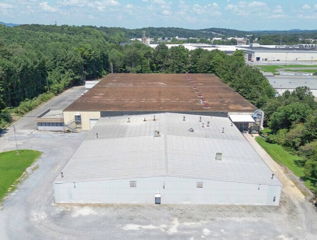

Property Detail
233 Brickyard Rd
12-333-02-000
BRICKYARD RD
Industrialgeneral
WHITFIELD
M2
Georgia
B and X Area of moderate flood hazard, usually the area between the limits of the 100-year and 500-year floods.
333
2025
11.30 AC
2025
Georgia Northwest
001200
Other Market Areas
143,379 SF
Dalton, GA
NEARBY LISTINGS FOR SALE OR LEASE
DEMOGRAPHICS near 233 Brickyard Rd
1 mile
3 mile
5 mile
2025 Total Population
2,627
19,510
51,449
2030 Population
2,704
19,939
52,712
Pop Growth 2025-2030
+ 2.93%
+ 2.20%
+ 2.45%
Average Age
37
38
38
2025 Total Households
842
6,639
17,638
HH Growth 2025-2030
+ 2.97%
+ 2.20%
+ 2.56%
Median Household Inc
$34,441
$48,944
$48,972
Avg Household Size
3.10
2.90
2.80
2025 Avg HH Vehicles
2.00
2.00
2.00
Median Home Value
$171,830
$239,036
$221,657
Median Year Built
1987
1981
1982
Nearby Places
Map Layers
Map Styles
 Street
 Aerial
Transit
 Traffic
 Biking
Places
Listings with unknown addresses are not visible on the map
- Restaurants
- Banks
- Shops
- Fitness
- Groceries
PUBLIC TRANSPORTATION
AIRPORT
Lovell Field
Drive
Walk
Distance
Lovell Field
45 min
32.2 mi
Freight Ports
Georgia Ports - Savannah
Drive
Walk
Distance
Georgia Ports - Savannah
374 min
333.4 mi
SALE & LEASE HISTORY
LISTING DATE
SALE/LEASE

Sep 15, 2025
For Sale
Nearby Properties
Address
Land Use
TOTAL SIZE
Lot Size
Zoning
Address
Land Use
TOTAL SIZE
Lot Size
Zoning
601,800 SF
33.86 AC
M-2
Address
Land Use
TOTAL SIZE
Lot Size
Zoning
513,638 SF
61.78 AC
M2
Address
Land Use
TOTAL SIZE
Lot Size
Zoning
232,960 SF
11.63 AC
M-2
Address
Land Use
TOTAL SIZE
Lot Size
Zoning
193,120 SF
41.95 AC
M-2
Address
Land Use
TOTAL SIZE
Lot Size
Zoning
200,000 SF
15.18 AC
M-2
Address
Land Use
TOTAL SIZE
Lot Size
Zoning
189,280 SF
8.18 AC
M-2
Address
Land Use
TOTAL SIZE
Lot Size
Zoning
1,183,067 SF
48.97 AC
M2
Address
Land Use
TOTAL SIZE
Lot Size
Zoning
193,716 SF
29.23 AC
Address
Land Use
TOTAL SIZE
Lot Size
Zoning
662,926 SF
67.28 AC
M2
Address
Land Use
TOTAL SIZE
Lot Size
Zoning
433,597 SF
36.86 AC
M2
Address
Land Use
TOTAL SIZE
Lot Size
Zoning
341,549 SF
25.46 AC
Address
Land Use
TOTAL SIZE
Lot Size
Zoning
115,979 SF
10.60 AC
C2
Address
Land Use
TOTAL SIZE
Lot Size
Zoning
276,936 SF
37.08 AC
M-2
Address
Land Use
TOTAL SIZE
Lot Size
Zoning
760,961 SF
24.63 AC
M2
Address
Land Use
TOTAL SIZE
Lot Size
Zoning
250,000 SF
12.50 AC
M2
Address
Land Use
TOTAL SIZE
Lot Size
Zoning
255,350 SF
18.64 AC
Address
Land Use
TOTAL SIZE
Lot Size
Zoning
150,772 SF
12.66 AC
C2
Address
Land Use
TOTAL SIZE
Lot Size
Zoning
130,290 SF
23.82 AC
Address
Land Use
TOTAL SIZE
Lot Size
Zoning
100,170 SF
7.83 AC
M-2
Address
Land Use
TOTAL SIZE
Lot Size
Zoning
184,747 SF
87.57 AC
Address
Land Use
TOTAL SIZE
Lot Size
Zoning
18,016 SF
27.65 AC
M-2
Address
Land Use
TOTAL SIZE
Lot Size
Zoning
38,016 SF
18 AC
Address
Land Use
TOTAL SIZE
Lot Size
Zoning
150,000 SF
6.36 AC
M2
Address
Land Use
TOTAL SIZE
Lot Size
Zoning
281,625 SF
19.58 AC
M2
Address
Land Use
TOTAL SIZE
Lot Size
Zoning
1,125,548 SF
24.22 AC
M2
Address
Land Use
TOTAL SIZE
Lot Size
Zoning
283,000 SF
29.32 AC
Address
Land Use
TOTAL SIZE
Lot Size
Zoning
31,376 SF
9.64 AC
Address
Land Use
TOTAL SIZE
Lot Size
Zoning
227,111 SF
16.09 AC
Address
Land Use
TOTAL SIZE
Lot Size
Zoning
471,045 SF
45.93 AC
M2
Address
Land Use
TOTAL SIZE
Lot Size
Zoning
261,000 SF
9.88 AC
The World's #1 Commercial Real Estate Marketplace
Connect with us
© 2026 CoStar Group
The information above has been obtained from sources believed reliable. While we do not doubt its accuracy we have not verified it and make no guarantee, warranty or representation about it. It is your responsibility to independently confirm its accuracy and completeness. Any projections, opinions, assumptions, or estimates used are for example only and do not represent the current or future performance of the property. The value of this transaction to you depends on tax and other factors which should be evaluated by your tax, financial, and legal advisors. You and your advisors should conduct a careful, independent investigation of the property to determine to your satisfaction the suitability of the property for your needs.