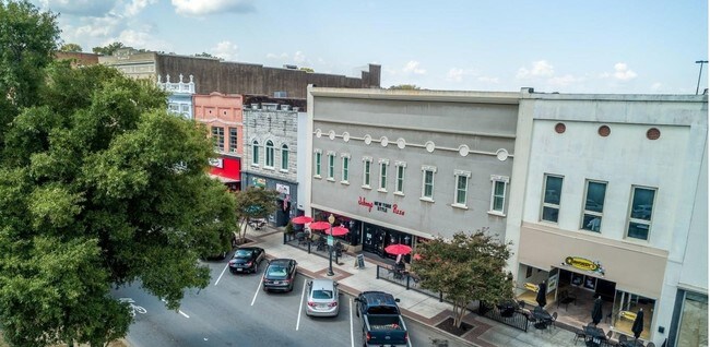
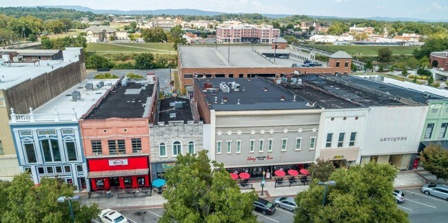
Property Record
233 Broad St, Rome, GA 30161
NEARBY LISTINGS FOR SALE OR LEASE
Property Detail
233 Broad St
Rome, GA
Coosa Division
J14D-052
LT49 COOSA DIV CITY OF ROME & 1/2 BRK WALL
Restaurantbuilding
Floyd
AE
Georgia
13115C0193E
49
2024
0.18 AC
2024
Georgia Northwest
001100
Other Market Areas
16,320 SF
DEMOGRAPHICS near 233 Broad St
1 Mile
3 Mile
5 Mile
2024 Total Population
5,552
35,426
61,634
2029 Population
5,794
36,530
63,187
Pop Growth 2024-2029
+ 4.36%
+ 3.12%
+ 2.52%
Average Age
41
38
38
2024 Total Households
2,472
13,179
22,757
HH Growth 2024-2029
+ 4.41%
+ 3.40%
+ 2.65%
Median Household Inc
$38,241
$48,465
$55,847
Avg Household Size
2.10
2.40
2.50
2024 Avg HH Vehicles
1.00
2.00
2.00
Median Home Value
$196,110
$187,704
$177,249
Median Year Built
1957
1968
1972
Nearby Places
- Restaurants
- Banks
- Shops
- Fitness
- Groceries
SALE & LEASE HISTORY
LISTING DATE
SALE/LEASE

Sep 24, 2016
For Sale
Oct 05, 2018
For Sale
Mar 27, 2019
For Sale
Nearby Properties
Address
Land Use
TOTAL SIZE
Lot Size
Zoning
Address
Land Use
TOTAL SIZE
Lot Size
Zoning
136,498 SF
9.23 AC
O-I
Address
Land Use
TOTAL SIZE
Lot Size
Zoning
1 SF
767.46 AC
O-I
Address
Land Use
TOTAL SIZE
Lot Size
Zoning
18.34 AC
O-I
Address
Land Use
TOTAL SIZE
Lot Size
Zoning
108,547 SF
1.54 AC
U-M-U
Address
Land Use
TOTAL SIZE
Lot Size
Zoning
20,532 SF
16.56 AC
C-C
Address
Land Use
TOTAL SIZE
Lot Size
Zoning
4,394 SF
14.26 AC
Address
Land Use
TOTAL SIZE
Lot Size
Zoning
30,991 SF
8.94 AC
Address
Land Use
TOTAL SIZE
Lot Size
Zoning
141,680 SF
6.27 AC
U-M-U
Address
Land Use
TOTAL SIZE
Lot Size
Zoning
57.50 AC
O-I
Address
Land Use
TOTAL SIZE
Lot Size
Zoning
1,980 SF
40.80 AC
H-I
Address
Land Use
TOTAL SIZE
Lot Size
Zoning
54,817 SF
8.82 AC
C-C
Address
Land Use
TOTAL SIZE
Lot Size
Zoning
83,971 SF
0.29 AC
Address
Land Use
TOTAL SIZE
Lot Size
Zoning
75,156 SF
7.10 AC
O-I
Address
Land Use
TOTAL SIZE
Lot Size
Zoning
3,416 SF
13.87 AC
C-C
Address
Land Use
TOTAL SIZE
Lot Size
Zoning
52,321 SF
Address
Land Use
TOTAL SIZE
Lot Size
Zoning
17,904 SF
14.19 AC
H-I
Address
Land Use
TOTAL SIZE
Lot Size
Zoning
47,541 SF
5.24 AC
O-I
Address
Land Use
TOTAL SIZE
Lot Size
Zoning
137,726 SF
12.51 AC
C-C
Address
Land Use
TOTAL SIZE
Lot Size
Zoning
59,796 SF
Address
Land Use
TOTAL SIZE
Lot Size
Zoning
30,267 SF
7.20 AC
C-C
Address
Land Use
TOTAL SIZE
Lot Size
Zoning
59,082 SF
8 AC
C-C
Address
Land Use
TOTAL SIZE
Lot Size
Zoning
19.64 AC
Address
Land Use
TOTAL SIZE
Lot Size
Zoning
89,250 SF
7.05 AC
C-C
Address
Land Use
TOTAL SIZE
Lot Size
Zoning
42,440 SF
4.30 AC
C-C
Address
Land Use
TOTAL SIZE
Lot Size
Zoning
313,467 SF
0.13 AC
H-I
Address
Land Use
TOTAL SIZE
Lot Size
Zoning
6,998 SF
15 AC
M-R
Address
Land Use
TOTAL SIZE
Lot Size
Zoning
26.30 AC
H-I
Address
Land Use
TOTAL SIZE
Lot Size
Zoning
11.84 AC
Address
Land Use
TOTAL SIZE
Lot Size
Zoning
61,577 SF
1.31 AC
C-C
Address
Land Use
TOTAL SIZE
Lot Size
Zoning
6.35 AC
M-R
The World's #1 Commercial Real Estate Marketplace
Connect with us
© 2025 CoStar Group
The information above has been obtained from sources believed reliable. While we do not doubt its accuracy we have not verified it and make no guarantee, warranty or representation about it. It is your responsibility to independently confirm its accuracy and completeness. Any projections, opinions, assumptions, or estimates used are for example only and do not represent the current or future performance of the property. The value of this transaction to you depends on tax and other factors which should be evaluated by your tax, financial, and legal advisors. You and your advisors should conduct a careful, independent investigation of the property to determine to your satisfaction the suitability of the property for your needs.