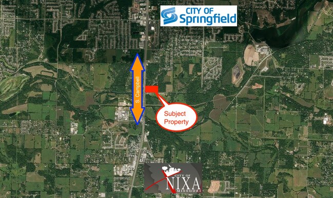
Property Record
233 E Farm Road 192, Springfield, MO 65810

Save to a Folder
{{folder.Name}}
{{folder.ListingIds.length}} Properties
{{folder.ListingIds.length}} Property
Create a New Folder
Property Detail
233 E Farm Road 192
18-25-300-043
5.67A M/L BEG 417.42 FT W E LN NW1/4 SW1/4 25/28/22 & N R/W JAMES RIVER RD WTO E R/W OLD CAMPBELL RD N ALD R/W 234.79 FT TO SW COR OAK HILL TER SUB E592.59 FT S TO BEG
Agriculturalland
GREENE
R-1
Missouri
B and X Area of moderate flood hazard, usually the area between the limits of the 100-year and 500-year floods.
5.67 AC
2025
Southeast
2025
Springfield
004003
Springfield, MO
NEARBY LISTINGS FOR SALE OR LEASE
DEMOGRAPHICS near 233 E Farm Road 192
1 mile
3 mile
5 mile
2025 Total Population
2,916
36,616
117,674
2030 Population
3,033
37,883
121,705
Pop Growth 2025-2030
+ 4.01%
+ 3.46%
+ 3.43%
Average Age
41
42
41
2025 Total Households
1,095
14,932
49,934
HH Growth 2025-2030
+ 3.93%
+ 3.41%
+ 3.33%
Median Household Inc
$102,130
$84,010
$70,629
Avg Household Size
2.60
2.40
2.30
2025 Avg HH Vehicles
2.00
2.00
2.00
Median Home Value
$335,752
$315,161
$284,305
Median Year Built
1994
1994
1992
Nearby Places
Map Layers
Map Styles
 Street
 Aerial
Layers
 Traffic
 Biking
Places
Listings with unknown addresses are not visible on the map
- Restaurants
- Banks
- Shops
- Fitness
- Groceries
PUBLIC TRANSPORTATION
AIRPORT
Springfield-Branson Ntl
Drive
Walk
Distance
Springfield-Branson Ntl
32 min
17.1 mi
Freight Ports
Tulsa Port of Inola
Drive
Walk
Distance
Tulsa Port of Inola
195 min
174.8 mi
SALE & LEASE HISTORY
LISTING DATE
SALE/LEASE

Jul 01, 2019
For Sale
Nearby Properties
Address
Land Use
TOTAL SIZE
Lot Size
Zoning
Address
Land Use
TOTAL SIZE
Lot Size
Zoning
18.52 AC
INC
Address
Land Use
TOTAL SIZE
Lot Size
Zoning
284,904 SF
24.38 AC
INC
Address
Land Use
TOTAL SIZE
Lot Size
Zoning
1.98 AC
INC.
Address
Land Use
TOTAL SIZE
Lot Size
Zoning
11.56 AC
INC
Address
Land Use
TOTAL SIZE
Lot Size
Zoning
140,147 SF
17.64 AC
INC
Address
Land Use
TOTAL SIZE
Lot Size
Zoning
42,540 SF
3.63 AC
INC
Address
Land Use
TOTAL SIZE
Lot Size
Zoning
86,566 SF
9.63 AC
INC
Address
Land Use
TOTAL SIZE
Lot Size
Zoning
47,214 SF
4.25 AC
INC
Address
Land Use
TOTAL SIZE
Lot Size
Zoning
5,310 SF
12.27 AC
Address
Land Use
TOTAL SIZE
Lot Size
Zoning
18.16 AC
Address
Land Use
TOTAL SIZE
Lot Size
Zoning
4.12 AC
INC
Address
Land Use
TOTAL SIZE
Lot Size
Zoning
5.59 AC
INC
Address
Land Use
TOTAL SIZE
Lot Size
Zoning
5,360 SF
9.71 AC
Address
Land Use
TOTAL SIZE
Lot Size
Zoning
3.97 AC
INC.
Address
Land Use
TOTAL SIZE
Lot Size
Zoning
21.59 AC
INC
Address
Land Use
TOTAL SIZE
Lot Size
Zoning
126,557 SF
4.62 AC
INC
Address
Land Use
TOTAL SIZE
Lot Size
Zoning
47,824 SF
2.09 AC
INC
Address
Land Use
TOTAL SIZE
Lot Size
Zoning
53,333 SF
1.93 AC
INC
Address
Land Use
TOTAL SIZE
Lot Size
Zoning
4.16 AC
INC
Address
Land Use
TOTAL SIZE
Lot Size
Zoning
125,218 SF
4.68 AC
INC
Address
Land Use
TOTAL SIZE
Lot Size
Zoning
1,680 SF
5 AC
INC.
Address
Land Use
TOTAL SIZE
Lot Size
Zoning
43,010 SF
3.71 AC
INC
Address
Land Use
TOTAL SIZE
Lot Size
Zoning
8.63 AC
INC.
Address
Land Use
TOTAL SIZE
Lot Size
Zoning
9,841 SF
7.17 AC
Address
Land Use
TOTAL SIZE
Lot Size
Zoning
7.63 AC
INC
Address
Land Use
TOTAL SIZE
Lot Size
Zoning
63,149 SF
6.01 AC
INC
Address
Land Use
TOTAL SIZE
Lot Size
Zoning
1,640 SF
24.20 AC
Address
Land Use
TOTAL SIZE
Lot Size
Zoning
33,318 SF
4 AC
INC
Address
Land Use
TOTAL SIZE
Lot Size
Zoning
45,071 SF
1.98 AC
INC
Address
Land Use
TOTAL SIZE
Lot Size
Zoning
5.25 AC
INC
The World's #1 Commercial Real Estate Marketplace
Connect with us
© 2026 CoStar Group
The information above has been obtained from sources believed reliable. While we do not doubt its accuracy we have not verified it and make no guarantee, warranty or representation about it. It is your responsibility to independently confirm its accuracy and completeness. Any projections, opinions, assumptions, or estimates used are for example only and do not represent the current or future performance of the property. The value of this transaction to you depends on tax and other factors which should be evaluated by your tax, financial, and legal advisors. You and your advisors should conduct a careful, independent investigation of the property to determine to your satisfaction the suitability of the property for your needs.