Property Record
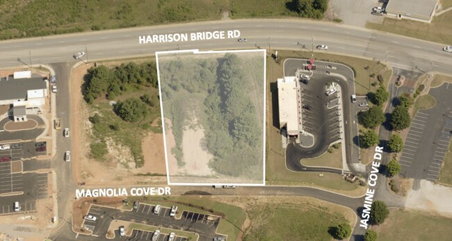
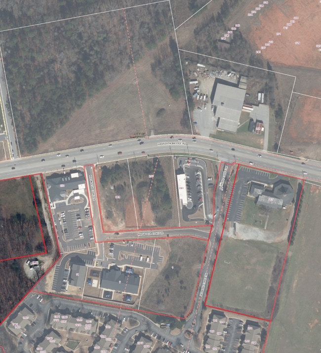
233 Harrison Bridge Rd, Simpsonville, SC 29680


Property Detail
233 Harrison Bridge Rd
Greenville-Anderson-Greer, SC
MAP 0331.00
0331.00-01-006.04
GREENVILLE
Religious
South Carolina
ROI
006.04
B and X Area of moderate flood hazard, usually the area between the limits of the 100-year and 500-year floods.
17.39 AC
2025
Mauldin/Fountain
2025
Greenville/Spartanburg
003013
NEARBY LISTINGS FOR SALE OR LEASE
DEMOGRAPHICS near 233 Harrison Bridge Rd
1 mile
3 mile
5 mile
2025 Total Population
4,418
46,109
85,105
2030 Population
4,813
49,812
91,969
Pop Growth 2025-2030
+ 8.94%
+ 8.03%
+ 8.07%
Average Age
38
40
40
2025 Total Households
1,680
17,648
32,185
HH Growth 2025-2030
+ 9.17%
+ 8.26%
+ 8.31%
Median Household Inc
$92,071
$89,660
$90,313
Avg Household Size
2.60
2.60
2.60
2025 Avg HH Vehicles
2.00
2.00
2.00
Median Home Value
$292,299
$326,527
$322,265
Median Year Built
2010
1999
2000
Nearby Places
Map Layers
Map Styles
 Street
 Aerial
Layers
 Traffic
 Biking
Places
Listings with unknown addresses are not visible on the map
- Restaurants
- Banks
- Shops
- Fitness
- Groceries
PUBLIC TRANSPORTATION
AIRPORT
Greenville Spartanburg International
Drive
Walk
Distance
Greenville Spartanburg International
27 min
18.3 mi
Freight Ports
North Charleston Terminal
Drive
Walk
Distance
North Charleston Terminal
211 min
188.1 mi
SALE & LEASE HISTORY
LISTING DATE
SALE/LEASE

Dec 09, 2021
For Sale
Nearby Properties
Address
Land Use
TOTAL SIZE
Lot Size
Zoning
Address
Land Use
TOTAL SIZE
Lot Size
Zoning
40.61 AC
I1
Address
Land Use
TOTAL SIZE
Lot Size
Zoning
103.69 AC
RRROW
Address
Land Use
TOTAL SIZE
Lot Size
Zoning
16.32 AC
ROI
Address
Land Use
TOTAL SIZE
Lot Size
Zoning
Address
Land Use
TOTAL SIZE
Lot Size
Zoning
21.78 AC
I1
Address
Land Use
TOTAL SIZE
Lot Size
Zoning
17.02 AC
BG
Address
Land Use
TOTAL SIZE
Lot Size
Zoning
14.75 AC
Address
Land Use
TOTAL SIZE
Lot Size
Zoning
Address
Land Use
TOTAL SIZE
Lot Size
Zoning
15.05 AC
I1
Address
Land Use
TOTAL SIZE
Lot Size
Zoning
25.87 AC
I1
Address
Land Use
TOTAL SIZE
Lot Size
Zoning
63.14 AC
I1
Address
Land Use
TOTAL SIZE
Lot Size
Zoning
191 SF
98.20 AC
I1
Address
Land Use
TOTAL SIZE
Lot Size
Zoning
10.04 AC
BG
Address
Land Use
TOTAL SIZE
Lot Size
Zoning
31.37 AC
I1
Address
Land Use
TOTAL SIZE
Lot Size
Zoning
12.05 AC
RS
Address
Land Use
TOTAL SIZE
Lot Size
Zoning
4.59 AC
BI
Address
Land Use
TOTAL SIZE
Lot Size
Zoning
15.59 AC
I1
Address
Land Use
TOTAL SIZE
Lot Size
Zoning
1,158 SF
5.11 AC
I1
Address
Land Use
TOTAL SIZE
Lot Size
Zoning
12.11 AC
BG
Address
Land Use
TOTAL SIZE
Lot Size
Zoning
22.60 AC
R12
Address
Land Use
TOTAL SIZE
Lot Size
Zoning
12.73 AC
I1
Address
Land Use
TOTAL SIZE
Lot Size
Zoning
9.89 AC
C2
Address
Land Use
TOTAL SIZE
Lot Size
Zoning
5.30 AC
BI
Address
Land Use
TOTAL SIZE
Lot Size
Zoning
76.20 AC
R20
Address
Land Use
TOTAL SIZE
Lot Size
Zoning
10.50 AC
RRROW
Address
Land Use
TOTAL SIZE
Lot Size
Zoning
14.60 AC
I1
Address
Land Use
TOTAL SIZE
Lot Size
Zoning
Address
Land Use
TOTAL SIZE
Lot Size
Zoning
89.72 AC
RLO
Address
Land Use
TOTAL SIZE
Lot Size
Zoning
7.10 AC
BG
The World's #1 Commercial Real Estate Marketplace
Connect with us
© 2026 CoStar Group
The information above has been obtained from sources believed reliable. While we do not doubt its accuracy we have not verified it and make no guarantee, warranty or representation about it. It is your responsibility to independently confirm its accuracy and completeness. Any projections, opinions, assumptions, or estimates used are for example only and do not represent the current or future performance of the property. The value of this transaction to you depends on tax and other factors which should be evaluated by your tax, financial, and legal advisors. You and your advisors should conduct a careful, independent investigation of the property to determine to your satisfaction the suitability of the property for your needs.