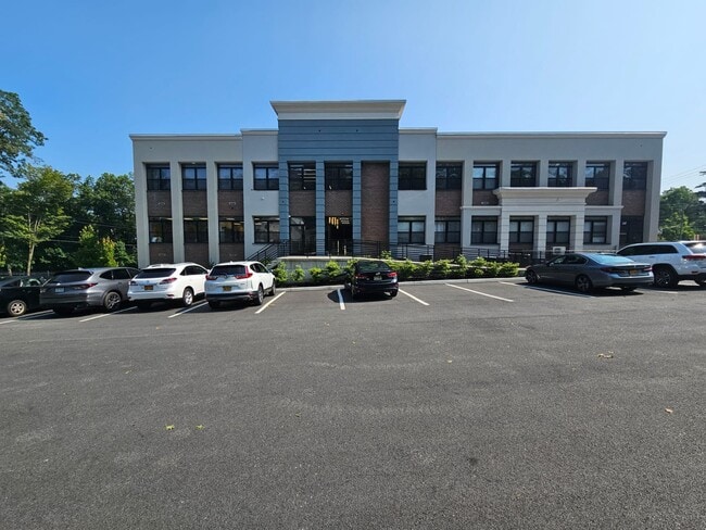
Property Record
233 Lafayette Ave, Suffern, NY 10901


Current Lease Availabilities
NEARBY LISTINGS FOR SALE OR LEASE
Property Detail
233 Lafayette Ave
New York-Jersey City-White Plains, NY-NJ
Buena Vista Heights Sec 01
392607-055-038-0001-004-000-0000
+ 776A2
Commercialbuilding
Rockland
X
New York
34003C0057H
4.0
2023
0.84 AC
2024
Ramapo
011901
Northern New Jersey
16,500 SF
DEMOGRAPHICS near 233 Lafayette Ave
1 Mile
3 Mile
5 Mile
2024 Total Population
15,153
50,320
160,864
2029 Population
15,074
50,326
160,517
Pop Growth 2024-2029
(0.52%)
+ 0.01%
(0.22%)
Average Age
43
41
35
2024 Total Households
6,106
18,062
46,994
HH Growth 2024-2029
(0.52%)
(0.03%)
(0.14%)
Median Household Inc
$99,111
$104,361
$96,882
Avg Household Size
2.40
2.70
3.20
2024 Avg HH Vehicles
2.00
2.00
2.00
Median Home Value
$346,226
$531,097
$647,443
Median Year Built
1970
1976
1974
Nearby Places
Map Layers
Map Styles
 Street
 Aerial
- Restaurants
- Banks
- Shops
- Fitness
- Groceries
PUBLIC TRANSPORTATION
COMMUTER RAIL
Suffern (Bergen County/Port Jervis Line - NJ Transit Commuter Rail (NJ Transit), Main/Port Jervis Line - NJ Transit Commuter Rail (NJ Transit))
DRIVE
WALK
Distance
Suffern (Bergen County/Port Jervis Line - NJ Transit Commuter Rail (NJ Transit), Main/Port Jervis Line - NJ Transit Commuter Rail (NJ Transit))
2 min
20 min
1.1 mi
Mahwah (Bergen County/Port Jervis Line - NJ Transit Commuter Rail (NJ Transit), Main/Port Jervis Line - NJ Transit Commuter Rail (NJ Transit))
DRIVE
WALK
Distance
Mahwah (Bergen County/Port Jervis Line - NJ Transit Commuter Rail (NJ Transit), Main/Port Jervis Line - NJ Transit Commuter Rail (NJ Transit))
4 min
2.2 mi
AIRPORT
Westchester County
DRIVE
WALK
Distance
Westchester County
42 min
29.9 mi
LaGuardia
DRIVE
WALK
Distance
LaGuardia
53 min
34.4 mi
New York Stewart International
DRIVE
WALK
Distance
New York Stewart International
48 min
36.0 mi
Freight Ports
Port Newark Container Terminal
DRIVE
WALK
Distance
Port Newark Container Terminal
53 min
36.3 mi
Nearby Properties
Address
Land Use
TOTAL SIZE
Lot Size
Zoning
Address
Land Use
TOTAL SIZE
Lot Size
Zoning
284 AC
P40
Address
Land Use
TOTAL SIZE
Lot Size
Zoning
28.28 AC
GI80
Address
Land Use
TOTAL SIZE
Lot Size
Zoning
46.89 AC
IP120
Address
Land Use
TOTAL SIZE
Lot Size
Zoning
1,056 SF
99.35 AC
OP200
Address
Land Use
TOTAL SIZE
Lot Size
Zoning
61.37 AC
PED
Address
Land Use
TOTAL SIZE
Lot Size
Zoning
17.71 AC
B3
Address
Land Use
TOTAL SIZE
Lot Size
Zoning
23.32 AC
Address
Land Use
TOTAL SIZE
Lot Size
Zoning
10.38 AC
Address
Land Use
TOTAL SIZE
Lot Size
Zoning
17.90 AC
IP
Address
Land Use
TOTAL SIZE
Lot Size
Zoning
2.33 AC
B3
Address
Land Use
TOTAL SIZE
Lot Size
Zoning
170,941 SF
10.04 AC
IP
Address
Land Use
TOTAL SIZE
Lot Size
Zoning
14.09 AC
B200
Address
Land Use
TOTAL SIZE
Lot Size
Zoning
106,836 SF
8.85 AC
LO
Address
Land Use
TOTAL SIZE
Lot Size
Zoning
Address
Land Use
TOTAL SIZE
Lot Size
Zoning
15.98 AC
Address
Land Use
TOTAL SIZE
Lot Size
Zoning
133,140 SF
8.10 AC
B3
Address
Land Use
TOTAL SIZE
Lot Size
Zoning
68.78 AC
OP20
Address
Land Use
TOTAL SIZE
Lot Size
Zoning
146,442 SF
7.97 AC
LO
Address
Land Use
TOTAL SIZE
Lot Size
Zoning
92,851 SF
8.66 AC
Address
Land Use
TOTAL SIZE
Lot Size
Zoning
19.60 AC
OP200
Address
Land Use
TOTAL SIZE
Lot Size
Zoning
5.67 AC
Address
Land Use
TOTAL SIZE
Lot Size
Zoning
6.76 AC
IP120
Address
Land Use
TOTAL SIZE
Lot Size
Zoning
33.78 AC
CEDR40
Address
Land Use
TOTAL SIZE
Lot Size
Zoning
539,911 SF
38.80 AC
05
Address
Land Use
TOTAL SIZE
Lot Size
Zoning
33.50 AC
GI80
Address
Land Use
TOTAL SIZE
Lot Size
Zoning
91,596 SF
15.10 AC
B40
Address
Land Use
TOTAL SIZE
Lot Size
Zoning
68,905 SF
7.28 AC
LO
Address
Land Use
TOTAL SIZE
Lot Size
Zoning
18.86 AC
IP120
Address
Land Use
TOTAL SIZE
Lot Size
Zoning
9.50 AC
Address
Land Use
TOTAL SIZE
Lot Size
Zoning
219,765 SF
29.88 AC
07
The World's #1 Commercial Real Estate Marketplace
Connect with us
© 2026 CoStar Group
The information above has been obtained from sources believed reliable. While we do not doubt its accuracy we have not verified it and make no guarantee, warranty or representation about it. It is your responsibility to independently confirm its accuracy and completeness. Any projections, opinions, assumptions, or estimates used are for example only and do not represent the current or future performance of the property. The value of this transaction to you depends on tax and other factors which should be evaluated by your tax, financial, and legal advisors. You and your advisors should conduct a careful, independent investigation of the property to determine to your satisfaction the suitability of the property for your needs.